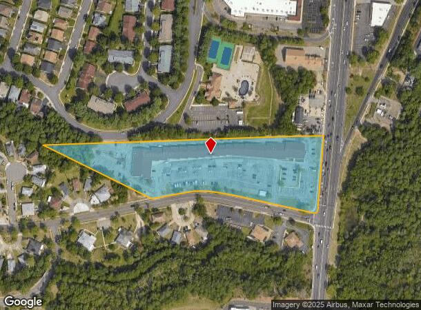
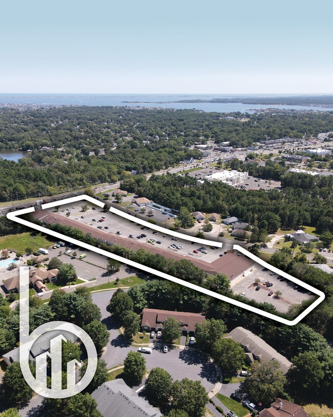
Property Record
2610 Yorktowne Blvd, Brick, NJ 08723


Current Lease Availabilities
NEARBY LISTINGS FOR SALE OR LEASE
Property Detail
2610 Yorktowne Blvd
New York-Jersey City-White Plains, NY-NJ
6.04 AC
07-00380-26-00002
Ocean
Commercialnec
New Jersey
X
2
34029C0194F
6.04 AC
2024
Ocean County
2025
Northern New Jersey
714100
DEMOGRAPHICS near 2610 Yorktowne Blvd
1 Mile
3 Mile
5 Mile
2024 Total Population
7,574
59,547
171,718
2029 Population
8,039
63,208
183,137
Pop Growth 2024-2029
+ 6.14%
+ 6.15%
+ 6.65%
Average Age
48
46
41
2024 Total Households
3,258
24,791
63,649
HH Growth 2024-2029
+ 5.59%
+ 5.45%
+ 6.47%
Median Household Inc
$61,431
$79,569
$80,054
Avg Household Size
2.20
2.30
2.50
2024 Avg HH Vehicles
2.00
2.00
2.00
Median Home Value
$283,940
$319,842
$348,621
Median Year Built
1978
1977
1977
Nearby Places
- Restaurants
- Banks
- Shops
- Fitness
- Groceries
PUBLIC TRANSPORTATION
COMMUTER RAIL
Bay Head (North Jersey Coast Line - NJ Transit Commuter Rail (NJ Transit))
DRIVE
WALK
Distance
Bay Head (North Jersey Coast Line - NJ Transit Commuter Rail (NJ Transit))
16 min
9.3 mi
Point Pleasant Beach (North Jersey Coast Line - NJ Transit Commuter Rail (NJ Transit))
DRIVE
WALK
Distance
Point Pleasant Beach (North Jersey Coast Line - NJ Transit Commuter Rail (NJ Transit))
16 min
9.4 mi
Freight Ports
New York Container Terminal
DRIVE
WALK
Distance
New York Container Terminal
73 min
55.1 mi
Nearby Properties
Address
Land Use
TOTAL SIZE
Lot Size
Zoning
Address
Land Use
TOTAL SIZE
Lot Size
Zoning
2,992 SF
290.86 AC
RC3
Address
Land Use
TOTAL SIZE
Lot Size
Zoning
45.53 AC
B3
Address
Land Use
TOTAL SIZE
Lot Size
Zoning
7,936 SF
25.60 AC
EM18
Address
Land Use
TOTAL SIZE
Lot Size
Zoning
22,175 SF
30.21 AC
RC
Address
Land Use
TOTAL SIZE
Lot Size
Zoning
29.34 AC
B4
Address
Land Use
TOTAL SIZE
Lot Size
Zoning
23,843 SF
37.83 AC
B5
Address
Land Use
TOTAL SIZE
Lot Size
Zoning
25.22 AC
B3
Address
Land Use
TOTAL SIZE
Lot Size
Zoning
1.80 AC
B5
Address
Land Use
TOTAL SIZE
Lot Size
Zoning
41,100 SF
14.63 AC
RC
Address
Land Use
TOTAL SIZE
Lot Size
Zoning
54.25 AC
RC3
Address
Land Use
TOTAL SIZE
Lot Size
Zoning
52.07 AC
RR2
Address
Land Use
TOTAL SIZE
Lot Size
Zoning
5,290 SF
12.95 AC
LP
Address
Land Use
TOTAL SIZE
Lot Size
Zoning
15.31 AC
B3
Address
Land Use
TOTAL SIZE
Lot Size
Zoning
19.40 AC
B3
Address
Land Use
TOTAL SIZE
Lot Size
Zoning
11.83 AC
B3
Address
Land Use
TOTAL SIZE
Lot Size
Zoning
9,429 SF
9.12 AC
B3
Address
Land Use
TOTAL SIZE
Lot Size
Zoning
47.75 AC
RR2
Address
Land Use
TOTAL SIZE
Lot Size
Zoning
32.50 AC
RM
Address
Land Use
TOTAL SIZE
Lot Size
Zoning
32.80 AC
RM
Address
Land Use
TOTAL SIZE
Lot Size
Zoning
15.68 AC
RUR
Address
Land Use
TOTAL SIZE
Lot Size
Zoning
10.84 AC
RM
Address
Land Use
TOTAL SIZE
Lot Size
Zoning
116,030 SF
13.96 AC
O10
Address
Land Use
TOTAL SIZE
Lot Size
Zoning
5,121 SF
26.15 AC
B3
Address
Land Use
TOTAL SIZE
Lot Size
Zoning
54,855 SF
6.23 AC
O10
Address
Land Use
TOTAL SIZE
Lot Size
Zoning
83,294 SF
9.59 AC
RC3
Address
Land Use
TOTAL SIZE
Lot Size
Zoning
106,436 SF
7.43 AC
RUR
Address
Land Use
TOTAL SIZE
Lot Size
Zoning
19.30 AC
RR2
Address
Land Use
TOTAL SIZE
Lot Size
Zoning
7.89 AC
RUR
Address
Land Use
TOTAL SIZE
Lot Size
Zoning
13.15 AC
B3
Address
Land Use
TOTAL SIZE
Lot Size
Zoning
55,052 SF
6.96 AC
O10
The World's #1 Commercial Real Estate Marketplace
Connect with us
© 2025 CoStar Group
The information above has been obtained from sources believed reliable. While we do not doubt its accuracy we have not verified it and make no guarantee, warranty or representation about it. It is your responsibility to independently confirm its accuracy and completeness. Any projections, opinions, assumptions, or estimates used are for example only and do not represent the current or future performance of the property. The value of this transaction to you depends on tax and other factors which should be evaluated by your tax, financial, and legal advisors. You and your advisors should conduct a careful, independent investigation of the property to determine to your satisfaction the suitability of the property for your needs.