Property Record
2610 Lake Cook Rd, Riverwoods, IL 60015
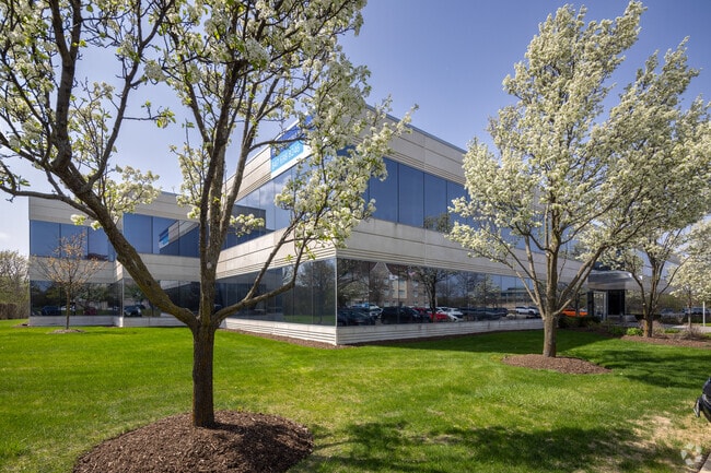

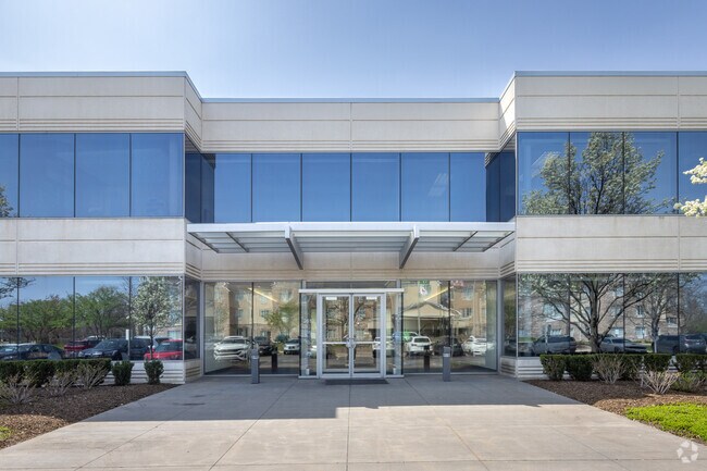
This Property Is For Sale
Current Lease Availabilities
NEARBY LISTINGS FOR SALE OR LEASE
Property Detail
2610 Lake Cook Rd
Chicago-Naperville-Elgin, IL-IN-WI
Chapel Hill Subdivision
15-36-402-011
CHAPEL HILL SUBDIVISION; LOT 1
Commercialbuilding
Lake
X
Illinois
17097C0270K
1
2023
2.88 AC
2024
Central North
864524
Chicago
DEMOGRAPHICS near 2610 Lake Cook Rd
1 Mile
3 Mile
5 Mile
2024 Total Population
2,880
72,511
215,544
2029 Population
2,837
71,159
210,968
Pop Growth 2024-2029
(1.49%)
(1.86%)
(2.12%)
Average Age
48
43
43
2024 Total Households
1,153
27,566
81,654
HH Growth 2024-2029
(1.82%)
(1.99%)
(2.36%)
Median Household Inc
$122,742
$103,550
$112,560
Avg Household Size
2.50
2.50
2.60
2024 Avg HH Vehicles
2.00
2.00
2.00
Median Home Value
$609,492
$444,305
$425,851
Median Year Built
1987
1977
1977
Nearby Places
Map Layers
Map Styles
 Street
 Aerial
- Restaurants
- Banks
- Shops
- Fitness
- Groceries
PUBLIC TRANSPORTATION
COMMUTER RAIL
Lake Cook Station (Milwaukee District North Line - Northeast Illinois Regional Commuter Railroad (Metra))
DRIVE
WALK
Distance
Lake Cook Station (Milwaukee District North Line - Northeast Illinois Regional Commuter Railroad (Metra))
7 min
2.8 mi
Wheeling Station (North Central Service - Northeast Illinois Regional Commuter Railroad (Metra))
DRIVE
WALK
Distance
Wheeling Station (North Central Service - Northeast Illinois Regional Commuter Railroad (Metra))
8 min
3.2 mi
AIRPORT
Chicago O'Hare International
DRIVE
WALK
Distance
Chicago O'Hare International
23 min
15.4 mi
Chicago Midway International
DRIVE
WALK
Distance
Chicago Midway International
52 min
28.7 mi
Nearby Properties
Address
Land Use
TOTAL SIZE
Lot Size
Zoning
Address
Land Use
TOTAL SIZE
Lot Size
Zoning
6,783,684 SF
69.84 AC
Address
Land Use
TOTAL SIZE
Lot Size
Zoning
815,308 SF
12.95 AC
Address
Land Use
TOTAL SIZE
Lot Size
Zoning
708,522 SF
17.11 AC
Address
Land Use
TOTAL SIZE
Lot Size
Zoning
65.17 AC
Address
Land Use
TOTAL SIZE
Lot Size
Zoning
301,050 SF
11.22 AC
Address
Land Use
TOTAL SIZE
Lot Size
Zoning
864,590 SF
2.64 AC
Address
Land Use
TOTAL SIZE
Lot Size
Zoning
21.58 AC
Address
Land Use
TOTAL SIZE
Lot Size
Zoning
Address
Land Use
TOTAL SIZE
Lot Size
Zoning
24.64 AC
Address
Land Use
TOTAL SIZE
Lot Size
Zoning
315,160 SF
15.50 AC
Address
Land Use
TOTAL SIZE
Lot Size
Zoning
1,049,337 SF
24.57 AC
Address
Land Use
TOTAL SIZE
Lot Size
Zoning
8.21 AC
Address
Land Use
TOTAL SIZE
Lot Size
Zoning
653,040 SF
7.96 AC
Address
Land Use
TOTAL SIZE
Lot Size
Zoning
8,586,994 SF
10.41 AC
Address
Land Use
TOTAL SIZE
Lot Size
Zoning
14.26 AC
Address
Land Use
TOTAL SIZE
Lot Size
Zoning
188,987 SF
6.65 AC
Address
Land Use
TOTAL SIZE
Lot Size
Zoning
Address
Land Use
TOTAL SIZE
Lot Size
Zoning
186,646 SF
26.69 AC
Address
Land Use
TOTAL SIZE
Lot Size
Zoning
349,846 SF
5.11 AC
Address
Land Use
TOTAL SIZE
Lot Size
Zoning
13.88 AC
Address
Land Use
TOTAL SIZE
Lot Size
Zoning
221,786 SF
6.33 AC
Address
Land Use
TOTAL SIZE
Lot Size
Zoning
46.27 AC
Address
Land Use
TOTAL SIZE
Lot Size
Zoning
362,944 SF
12.74 AC
Address
Land Use
TOTAL SIZE
Lot Size
Zoning
Address
Land Use
TOTAL SIZE
Lot Size
Zoning
510,569 SF
3.55 AC
Address
Land Use
TOTAL SIZE
Lot Size
Zoning
247,655 SF
12.19 AC
Address
Land Use
TOTAL SIZE
Lot Size
Zoning
105,033 SF
5.21 AC
Address
Land Use
TOTAL SIZE
Lot Size
Zoning
738,489 SF
20.24 AC
Address
Land Use
TOTAL SIZE
Lot Size
Zoning
579,858 SF
3.56 AC
Address
Land Use
TOTAL SIZE
Lot Size
Zoning
158,046 SF
5.26 AC
The World's #1 Commercial Real Estate Marketplace
Connect with us
© 2025 CoStar Group
The information above has been obtained from sources believed reliable. While we do not doubt its accuracy we have not verified it and make no guarantee, warranty or representation about it. It is your responsibility to independently confirm its accuracy and completeness. Any projections, opinions, assumptions, or estimates used are for example only and do not represent the current or future performance of the property. The value of this transaction to you depends on tax and other factors which should be evaluated by your tax, financial, and legal advisors. You and your advisors should conduct a careful, independent investigation of the property to determine to your satisfaction the suitability of the property for your needs.