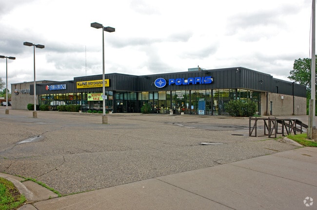
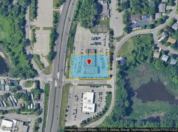
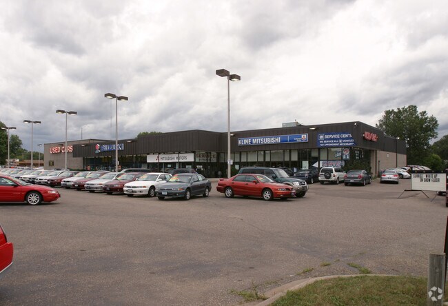
Property Record
2610 Maplewood Dr N, Saint Paul, MN 55109
NEARBY LISTINGS FOR SALE OR LEASE
Property Detail
2610 Maplewood Dr N
Minneapolis-St. Paul-Bloomington, MN-WI
Speisers Arbolada
09-29-22-11-0071
SPEISERS ARBOLADA SUBJ TO RD & ESMTS & VAC RD ACCRUING; PART OF ...& ALL OF LOTS 6 THRU LOT 9 BLK 1
Vehiclerentalsvehiclesales
Ramsey
X
Minnesota
27003C0450E
6
2024
1.99 AC
2025
Maplewood
042301
Minneapolis/St Paul
26,979 SF
DEMOGRAPHICS near 2610 Maplewood Dr N
1 Mile
3 Mile
5 Mile
2024 Total Population
4,221
84,164
257,326
2029 Population
4,070
81,588
251,522
Pop Growth 2024-2029
(3.58%)
(3.06%)
(2.26%)
Average Age
43
39
38
2024 Total Households
1,616
31,417
94,922
HH Growth 2024-2029
(3.90%)
(3.25%)
(2.34%)
Median Household Inc
$96,385
$69,898
$70,221
Avg Household Size
2.50
2.60
2.60
2024 Avg HH Vehicles
2.00
2.00
2.00
Median Home Value
$313,844
$263,640
$265,941
Median Year Built
1981
1972
1970
Nearby Places
Map Layers
Map Styles
 Street
 Aerial
- Restaurants
- Banks
- Shops
- Fitness
- Groceries
PUBLIC TRANSPORTATION
COMMUTER RAIL
DRIVE
WALK
Distance
13 min
7.4 mi
AIRPORT
Minneapolis-St Paul International/Wold-Chamberlain
DRIVE
WALK
Distance
Minneapolis-St Paul International/Wold-Chamberlain
27 min
16.1 mi
Nearby Properties
Address
Land Use
TOTAL SIZE
Lot Size
Zoning
Address
Land Use
TOTAL SIZE
Lot Size
Zoning
267,576 SF
18.95 AC
Address
Land Use
TOTAL SIZE
Lot Size
Zoning
5.59 AC
Address
Land Use
TOTAL SIZE
Lot Size
Zoning
4,800 SF
20.36 AC
Address
Land Use
TOTAL SIZE
Lot Size
Zoning
47,670 SF
179 AC
Address
Land Use
TOTAL SIZE
Lot Size
Zoning
273,937 SF
16.75 AC
Address
Land Use
TOTAL SIZE
Lot Size
Zoning
143,922 SF
23.12 AC
Address
Land Use
TOTAL SIZE
Lot Size
Zoning
250,050 SF
2.99 AC
Address
Land Use
TOTAL SIZE
Lot Size
Zoning
246,000 SF
31.03 AC
Address
Land Use
TOTAL SIZE
Lot Size
Zoning
233,419 SF
5.67 AC
Address
Land Use
TOTAL SIZE
Lot Size
Zoning
74,082 SF
12.10 AC
Address
Land Use
TOTAL SIZE
Lot Size
Zoning
90,293 SF
9.33 AC
Address
Land Use
TOTAL SIZE
Lot Size
Zoning
138,407 SF
15.67 AC
Address
Land Use
TOTAL SIZE
Lot Size
Zoning
313,546 SF
7.33 AC
Address
Land Use
TOTAL SIZE
Lot Size
Zoning
278,392 SF
8.04 AC
Address
Land Use
TOTAL SIZE
Lot Size
Zoning
96,587 SF
17.42 AC
Address
Land Use
TOTAL SIZE
Lot Size
Zoning
Address
Land Use
TOTAL SIZE
Lot Size
Zoning
35.93 AC
W7PUBLC
Address
Land Use
TOTAL SIZE
Lot Size
Zoning
1,500 SF
25.38 AC
Address
Land Use
TOTAL SIZE
Lot Size
Zoning
49,691 SF
10.94 AC
Address
Land Use
TOTAL SIZE
Lot Size
Zoning
211,420 SF
5.22 AC
Address
Land Use
TOTAL SIZE
Lot Size
Zoning
157,404 SF
40.84 AC
Address
Land Use
TOTAL SIZE
Lot Size
Zoning
17.16 AC
Address
Land Use
TOTAL SIZE
Lot Size
Zoning
212,078 SF
2.95 AC
Address
Land Use
TOTAL SIZE
Lot Size
Zoning
90,080 SF
12.81 AC
Address
Land Use
TOTAL SIZE
Lot Size
Zoning
118,442 SF
12.83 AC
Address
Land Use
TOTAL SIZE
Lot Size
Zoning
3.91 AC
Address
Land Use
TOTAL SIZE
Lot Size
Zoning
271,355 SF
20.56 AC
Address
Land Use
TOTAL SIZE
Lot Size
Zoning
126,852 SF
11.86 AC
Address
Land Use
TOTAL SIZE
Lot Size
Zoning
67,693 SF
7.30 AC
Address
Land Use
TOTAL SIZE
Lot Size
Zoning
145,458 SF
2.30 AC
The World's #1 Commercial Real Estate Marketplace
Connect with us
© 2025 CoStar Group
The information above has been obtained from sources believed reliable. While we do not doubt its accuracy we have not verified it and make no guarantee, warranty or representation about it. It is your responsibility to independently confirm its accuracy and completeness. Any projections, opinions, assumptions, or estimates used are for example only and do not represent the current or future performance of the property. The value of this transaction to you depends on tax and other factors which should be evaluated by your tax, financial, and legal advisors. You and your advisors should conduct a careful, independent investigation of the property to determine to your satisfaction the suitability of the property for your needs.