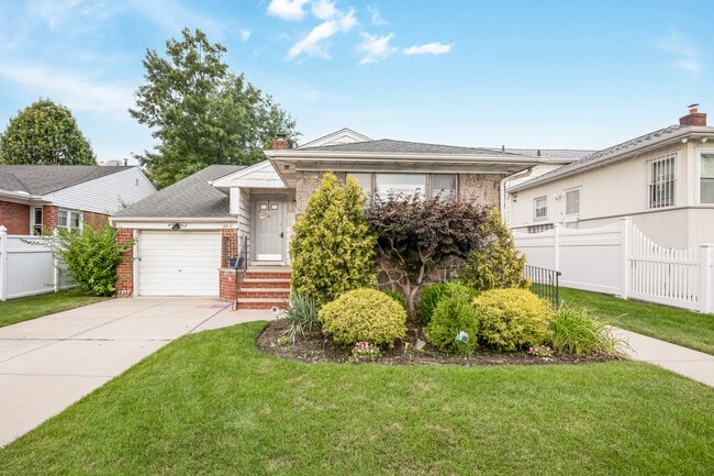
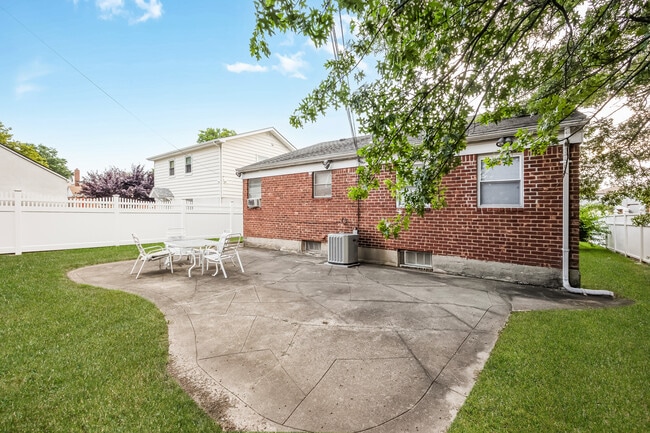
Property Record
2611 Corporal Kennedy St, Bayside, NY 11360

Save to a Folder
{{folder.Name}}
{{folder.ListingIds.length}} Properties
{{folder.ListingIds.length}} Property
Create a New Folder
Property Detail
2611 Corporal Kennedy St
05992-0004
Queens
Funeralhome
New York
R2A
4
B and X Area of moderate flood hazard, usually the area between the limits of the 100-year and 500-year floods.
0.12 AC
2025
Northeast Queens
2026
Long Island (New York)
109300
New York-Jersey City-White Plains, NY-NJ
1,725 SF
NEARBY LISTINGS FOR SALE OR LEASE
DEMOGRAPHICS near 2611 Corporal Kennedy St
1 mile
3 mile
5 mile
2025 Total Population
41,545
361,665
977,951
2030 Population
41,135
359,891
965,615
Pop Growth 2025-2030
(0.99%)
(0.49%)
(1.26%)
Average Age
48
45
43
2025 Total Households
16,656
129,529
331,470
HH Growth 2025-2030
(1.35%)
(0.89%)
(1.56%)
Median Household Inc
$101,929
$78,278
$82,318
Avg Household Size
2.40
2.70
2.80
2025 Avg HH Vehicles
1.00
1.00
1.00
Median Home Value
$735,893
$765,394
$725,672
Median Year Built
1959
1956
1956
Nearby Places
Map Layers
Map Styles
 Street
 Aerial
Layers
 Traffic
 Biking
Places
Listings with unknown addresses are not visible on the map
- Restaurants
- Banks
- Shops
- Fitness
- Groceries
PUBLIC TRANSPORTATION
COMMUTER RAIL
Bayside Station (Port Washington Branch - Long Island Rail Road)
Drive
Walk
Distance
Bayside Station (Port Washington Branch - Long Island Rail Road)
5 min
1.4 mi
Auburndale Station (Port Washington Branch - Long Island Rail Road)
Drive
Walk
Distance
Auburndale Station (Port Washington Branch - Long Island Rail Road)
4 min
1.5 mi
AIRPORT
LaGuardia
Drive
Walk
Distance
LaGuardia
16 min
6.5 mi
John F Kennedy International
Drive
Walk
Distance
John F Kennedy International
22 min
12.3 mi
Westchester County
Drive
Walk
Distance
Westchester County
41 min
26.6 mi
Freight Ports
NY - Red Hook Container Terminal
Drive
Walk
Distance
NY - Red Hook Container Terminal
29 min
17.1 mi
SALE & LEASE HISTORY
LISTING DATE
SALE/LEASE

Aug 07, 2025
For Sale
Nearby Properties
Address
Land Use
TOTAL SIZE
Lot Size
Zoning
Address
Land Use
TOTAL SIZE
Lot Size
Zoning
2,697,663 SF
3.46 AC
C5-3
Address
Land Use
TOTAL SIZE
Lot Size
Zoning
1,666,696 SF
1.87 AC
C52.5
Address
Land Use
TOTAL SIZE
Lot Size
Zoning
7,975 SF
133 AC
PARK
Address
Land Use
TOTAL SIZE
Lot Size
Zoning
878,386 SF
20.55 AC
R4
Address
Land Use
TOTAL SIZE
Lot Size
Zoning
800 SF
104.61 AC
PARK
Address
Land Use
TOTAL SIZE
Lot Size
Zoning
703,265 SF
83.45 AC
R4
Address
Land Use
TOTAL SIZE
Lot Size
Zoning
421,996 SF
136.05 AC
R3-1
Address
Land Use
TOTAL SIZE
Lot Size
Zoning
4,050 SF
113.40 AC
PARK
Address
Land Use
TOTAL SIZE
Lot Size
Zoning
947 SF
101.82 AC
PARK
Address
Land Use
TOTAL SIZE
Lot Size
Zoning
4,800 SF
80.10 AC
PARK
Address
Land Use
TOTAL SIZE
Lot Size
Zoning
332,266 SF
12.57 AC
M2-1
Address
Land Use
TOTAL SIZE
Lot Size
Zoning
1,186,778 SF
31.45 AC
R4
Address
Land Use
TOTAL SIZE
Lot Size
Zoning
511,684 SF
13.09 AC
R4
Address
Land Use
TOTAL SIZE
Lot Size
Zoning
377,896 SF
11.36 AC
R3-2
Address
Land Use
TOTAL SIZE
Lot Size
Zoning
226,990 SF
0.72 AC
C4-3
Address
Land Use
TOTAL SIZE
Lot Size
Zoning
198,298 SF
13.93 AC
C4-1
Address
Land Use
TOTAL SIZE
Lot Size
Zoning
186,843 SF
5.37 AC
R2A
Address
Land Use
TOTAL SIZE
Lot Size
Zoning
382,302 SF
6.23 AC
R2A
Address
Land Use
TOTAL SIZE
Lot Size
Zoning
2,828 SF
78.05 AC
PARK
Address
Land Use
TOTAL SIZE
Lot Size
Zoning
533,460 SF
27.75 AC
M1-1
Address
Land Use
TOTAL SIZE
Lot Size
Zoning
454,631 SF
24.61 AC
M1-1
Address
Land Use
TOTAL SIZE
Lot Size
Zoning
614,916 SF
28.10 AC
R4
Address
Land Use
TOTAL SIZE
Lot Size
Zoning
1,400 SF
42.67 AC
PARK
Address
Land Use
TOTAL SIZE
Lot Size
Zoning
15.83 AC
M2-1
Address
Land Use
TOTAL SIZE
Lot Size
Zoning
202,063 SF
2.79 AC
C4-2
Address
Land Use
TOTAL SIZE
Lot Size
Zoning
344,292 SF
12.56 AC
R4
Address
Land Use
TOTAL SIZE
Lot Size
Zoning
319,231 SF
3.76 AC
R4
Address
Land Use
TOTAL SIZE
Lot Size
Zoning
483,292 SF
23 AC
R4
Address
Land Use
TOTAL SIZE
Lot Size
Zoning
109,805 SF
1.96 AC
C4-2
Address
Land Use
TOTAL SIZE
Lot Size
Zoning
95.36 AC
PARK
The World's #1 Commercial Real Estate Marketplace
Connect with us
© 2026 CoStar Group
The information above has been obtained from sources believed reliable. While we do not doubt its accuracy we have not verified it and make no guarantee, warranty or representation about it. It is your responsibility to independently confirm its accuracy and completeness. Any projections, opinions, assumptions, or estimates used are for example only and do not represent the current or future performance of the property. The value of this transaction to you depends on tax and other factors which should be evaluated by your tax, financial, and legal advisors. You and your advisors should conduct a careful, independent investigation of the property to determine to your satisfaction the suitability of the property for your needs.