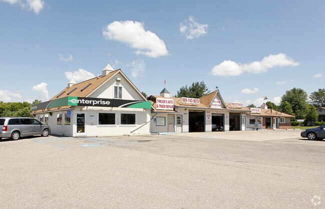
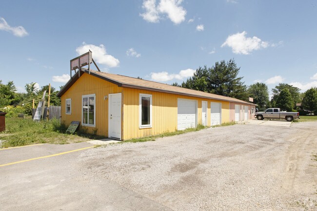
Property Record
2611 E M 21, Corunna, MI 48817

Property Detail
2611 E M 21
Owosso, MI
PART OF THE SOUTHEAST OF SECTION 16, T7N-R3E, CALEDONIA CHARTER TOWNSHIP, SHIAWASSEE COUNTY, MICHIGAN, DESCRIBED AS BEGINNING
007-16-400-012-01
Shiawassee
Commercialnec
Michigan
B and X Area of moderate flood hazard, usually the area between the limits of the 100-year and 500-year floods.
1.52 AC
2024
Midland/Flint
2025
Other Market Areas
031700
NEARBY LISTINGS FOR SALE OR LEASE
DEMOGRAPHICS near 2611 E M 21
1 mile
3 mile
5 mile
2025 Total Population
1,198
13,379
26,240
2030 Population
1,194
13,363
26,252
Pop Growth 2025-2030
(0.33%)
(0.12%)
+ 0.05%
Average Age
45
41
42
2025 Total Households
519
5,653
11,149
HH Growth 2025-2030
(0.39%)
(0.16%)
+ 0.03%
Median Household Inc
$48,437
$48,210
$49,782
Avg Household Size
2.20
2.30
2.30
2025 Avg HH Vehicles
2.00
2.00
2.00
Median Home Value
$182,068
$153,590
$150,874
Median Year Built
1972
1959
1959
Nearby Places
Map Layers
Map Styles
 Street
 Aerial
Layers
 Traffic
 Biking
Places
Listings with unknown addresses are not visible on the map
- Restaurants
- Banks
- Shops
- Fitness
- Groceries
PUBLIC TRANSPORTATION
AIRPORT
Bishop International
Drive
Walk
Distance
Bishop International
39 min
23.8 mi
Capital Region International
Drive
Walk
Distance
Capital Region International
52 min
41.6 mi
Nearby Properties
Address
Land Use
TOTAL SIZE
Lot Size
Zoning
Address
Land Use
TOTAL SIZE
Lot Size
Zoning
207,259 SF
24.89 AC
Address
Land Use
TOTAL SIZE
Lot Size
Zoning
171,070 SF
38 AC
Address
Land Use
TOTAL SIZE
Lot Size
Zoning
4,960 SF
6.83 AC
RA
Address
Land Use
TOTAL SIZE
Lot Size
Zoning
10,100 SF
17.75 AC
Address
Land Use
TOTAL SIZE
Lot Size
Zoning
7.10 AC
Address
Land Use
TOTAL SIZE
Lot Size
Zoning
93,128 SF
10.98 AC
Address
Land Use
TOTAL SIZE
Lot Size
Zoning
16,202 SF
5.15 AC
Address
Land Use
TOTAL SIZE
Lot Size
Zoning
50,301 SF
8.20 AC
Address
Land Use
TOTAL SIZE
Lot Size
Zoning
8.50 AC
RA
Address
Land Use
TOTAL SIZE
Lot Size
Zoning
56,456 SF
6.50 AC
Address
Land Use
TOTAL SIZE
Lot Size
Zoning
23,760 SF
383 AC
Address
Land Use
TOTAL SIZE
Lot Size
Zoning
15.80 AC
Address
Land Use
TOTAL SIZE
Lot Size
Zoning
11,014 SF
2.61 AC
Address
Land Use
TOTAL SIZE
Lot Size
Zoning
2.52 AC
Address
Land Use
TOTAL SIZE
Lot Size
Zoning
0.39 AC
Address
Land Use
TOTAL SIZE
Lot Size
Zoning
212,405 SF
29 AC
Address
Land Use
TOTAL SIZE
Lot Size
Zoning
24,116 SF
3.70 AC
Address
Land Use
TOTAL SIZE
Lot Size
Zoning
8.20 AC
Address
Land Use
TOTAL SIZE
Lot Size
Zoning
6,390 SF
9 AC
Address
Land Use
TOTAL SIZE
Lot Size
Zoning
21,068 SF
10.22 AC
RA
Address
Land Use
TOTAL SIZE
Lot Size
Zoning
3.22 AC
RA
Address
Land Use
TOTAL SIZE
Lot Size
Zoning
2.76 AC
Address
Land Use
TOTAL SIZE
Lot Size
Zoning
120,470 SF
8 AC
RA
Address
Land Use
TOTAL SIZE
Lot Size
Zoning
Address
Land Use
TOTAL SIZE
Lot Size
Zoning
Address
Land Use
TOTAL SIZE
Lot Size
Zoning
4.90 AC
Address
Land Use
TOTAL SIZE
Lot Size
Zoning
16,426 SF
1.70 AC
Address
Land Use
TOTAL SIZE
Lot Size
Zoning
3.01 AC
RA
Address
Land Use
TOTAL SIZE
Lot Size
Zoning
Address
Land Use
TOTAL SIZE
Lot Size
Zoning
17,176 SF
6.65 AC
The World's #1 Commercial Real Estate Marketplace
Connect with us
© 2026 CoStar Group
The information above has been obtained from sources believed reliable. While we do not doubt its accuracy we have not verified it and make no guarantee, warranty or representation about it. It is your responsibility to independently confirm its accuracy and completeness. Any projections, opinions, assumptions, or estimates used are for example only and do not represent the current or future performance of the property. The value of this transaction to you depends on tax and other factors which should be evaluated by your tax, financial, and legal advisors. You and your advisors should conduct a careful, independent investigation of the property to determine to your satisfaction the suitability of the property for your needs.