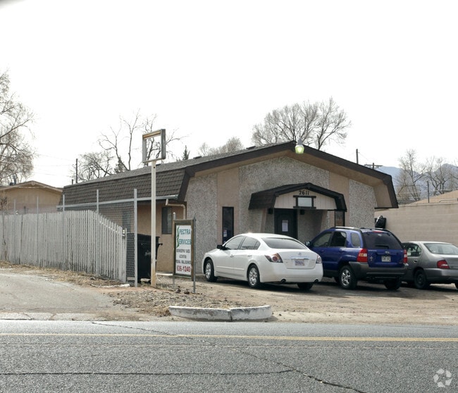
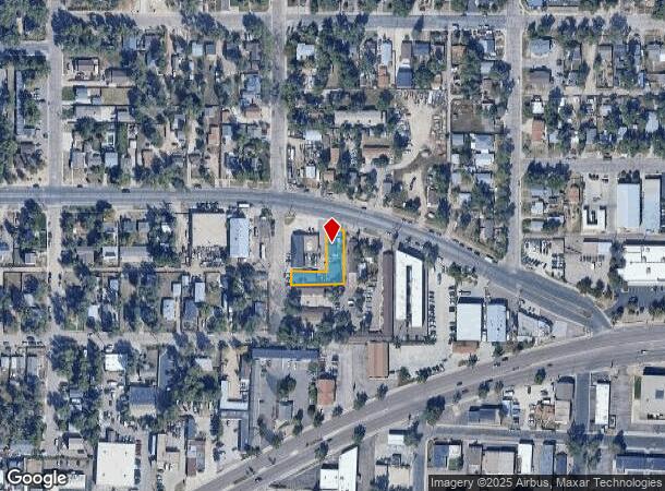
Property Record
2611 E Willamette Ave, Colorado Springs, CO 80909
Current Lease Availabilities
NEARBY LISTINGS FOR SALE OR LEASE
Property Detail
2611 E Willamette Ave
Colorado Springs, CO
East Hills
64094-14-022
El Paso
Sfr
Colorado
X
0.27 AC
08041C0734G
Southeast
2,960 SF
Colorado Springs
DEMOGRAPHICS near 2611 E Willamette Ave
1 Mile
3 Mile
5 Mile
2024 Total Population
15,773
128,939
285,203
2029 Population
16,532
135,172
297,861
Pop Growth 2024-2029
+ 4.81%
+ 4.83%
+ 4.44%
Average Age
39
38
38
2024 Total Households
7,082
54,536
119,077
HH Growth 2024-2029
+ 5.04%
+ 5.09%
+ 4.72%
Median Household Inc
$47,528
$54,529
$60,126
Avg Household Size
2.10
2.20
2.30
2024 Avg HH Vehicles
1.00
2.00
2.00
Median Home Value
$268,191
$319,549
$335,047
Median Year Built
1968
1971
1976
Nearby Places
Map Layers
Map Styles
 Street
 Aerial
- Restaurants
- Banks
- Shops
- Fitness
- Groceries
PUBLIC TRANSPORTATION
AIRPORT
City of Colorado Springs Municipal
DRIVE
WALK
Distance
City of Colorado Springs Municipal
14 min
6.7 mi
Nearby Properties
Address
Land Use
TOTAL SIZE
Lot Size
Zoning
Address
Land Use
TOTAL SIZE
Lot Size
Zoning
1,072,186 SF
15.14 AC
MX-N HR CU
Address
Land Use
TOTAL SIZE
Lot Size
Zoning
586,419 SF
17.77 AC
R-5 CU
Address
Land Use
TOTAL SIZE
Lot Size
Zoning
604,992 SF
28.95 AC
MX-T CU
Address
Land Use
TOTAL SIZE
Lot Size
Zoning
326,035 SF
33.75 AC
PCR UV
Address
Land Use
TOTAL SIZE
Lot Size
Zoning
123,725 SF
1.57 AC
FBZ-CEN
Address
Land Use
TOTAL SIZE
Lot Size
Zoning
229,081 SF
9.87 AC
MX-N CU SS
Address
Land Use
TOTAL SIZE
Lot Size
Zoning
271,048 SF
3.67 AC
FBZ-T2A
Address
Land Use
TOTAL SIZE
Lot Size
Zoning
151,674 SF
1.21 AC
FBZ-CEN
Address
Land Use
TOTAL SIZE
Lot Size
Zoning
200,642 SF
6.65 AC
MX-M HR AO
Address
Land Use
TOTAL SIZE
Lot Size
Zoning
167,120 SF
10.59 AC
MX-L/CR CU
Address
Land Use
TOTAL SIZE
Lot Size
Zoning
217,459 SF
3.67 AC
FBZ-CEN UV
Address
Land Use
TOTAL SIZE
Lot Size
Zoning
226,707 SF
3.25 AC
PF UV
Address
Land Use
TOTAL SIZE
Lot Size
Zoning
168,835 SF
33 AC
PF SS
Address
Land Use
TOTAL SIZE
Lot Size
Zoning
51,766 SF
4.53 AC
FBZ-CEN
Address
Land Use
TOTAL SIZE
Lot Size
Zoning
75,831 SF
3.37 AC
R-5 P
Address
Land Use
TOTAL SIZE
Lot Size
Zoning
130,451 SF
0.66 AC
FBZ-CEN
Address
Land Use
TOTAL SIZE
Lot Size
Zoning
138,773 SF
4.45 AC
R-5
Address
Land Use
TOTAL SIZE
Lot Size
Zoning
109,739 SF
18.61 AC
BP/CR CU
Address
Land Use
TOTAL SIZE
Lot Size
Zoning
123,644 SF
74.14 AC
GI PF SS
Address
Land Use
TOTAL SIZE
Lot Size
Zoning
420,063 SF
2.31 AC
FBZ-CEN
Address
Land Use
TOTAL SIZE
Lot Size
Zoning
50,519 SF
1.66 AC
FBZ-CEN
Address
Land Use
TOTAL SIZE
Lot Size
Zoning
1,294,065 SF
3.78 AC
FBZ-CEN
Address
Land Use
TOTAL SIZE
Lot Size
Zoning
70,985 SF
0.65 AC
FBZ-CEN
Address
Land Use
TOTAL SIZE
Lot Size
Zoning
113,594 SF
1.65 AC
R-5 HR
Address
Land Use
TOTAL SIZE
Lot Size
Zoning
184,595 SF
3.67 AC
R-1 6
Address
Land Use
TOTAL SIZE
Lot Size
Zoning
99,750 SF
0.92 AC
FBZ-CEN UV
Address
Land Use
TOTAL SIZE
Lot Size
Zoning
1,223 SF
725.94 AC
PF PK SS
Address
Land Use
TOTAL SIZE
Lot Size
Zoning
71,438 SF
9.81 AC
R-5/CR
Address
Land Use
TOTAL SIZE
Lot Size
Zoning
53,652 SF
0.52 AC
FBZ-T2A
Address
Land Use
TOTAL SIZE
Lot Size
Zoning
244,545 SF
1.14 AC
FBZ-CEN
The World's #1 Commercial Real Estate Marketplace
Connect with us
© 2026 CoStar Group
The information above has been obtained from sources believed reliable. While we do not doubt its accuracy we have not verified it and make no guarantee, warranty or representation about it. It is your responsibility to independently confirm its accuracy and completeness. Any projections, opinions, assumptions, or estimates used are for example only and do not represent the current or future performance of the property. The value of this transaction to you depends on tax and other factors which should be evaluated by your tax, financial, and legal advisors. You and your advisors should conduct a careful, independent investigation of the property to determine to your satisfaction the suitability of the property for your needs.