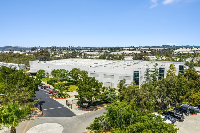
Property Record
2611 Island View Way, Vista, CA 92081

Current Lease Availabilities
NEARBY LISTINGS FOR SALE OR LEASE
Property Detail
2611 Island View Way
221-660-06
Vista
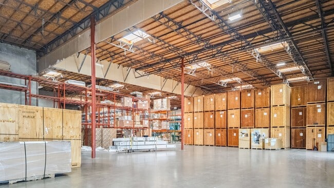
Lightindustrial
PAR J TR PM15413
X
San Diego
06073C0788J
California
2024
4.97 AC
2025
Vista
020017
San Diego
52,090 SF
San Diego-Carlsbad, CA
DEMOGRAPHICS near 2611 Island View Way
1 Mile
3 Mile
5 Mile
2024 Total Population
5,625
89,164
237,526
2029 Population
5,616
88,417
235,565
Pop Growth 2024-2029
(0.16%)
(0.84%)
(0.83%)
Average Age
48
41
40
2024 Total Households
2,370
32,270
82,330
HH Growth 2024-2029
0.00%
(0.95%)
(1.00%)
Median Household Inc
$90,995
$101,552
$106,735
Avg Household Size
2.40
2.70
2.80
2024 Avg HH Vehicles
2.00
2.00
2.00
Median Home Value
$554,953
$792,471
$821,202
Median Year Built
1988
1989
1989
Nearby Places
Map Layers
Map Styles
 Street
 Aerial
- Restaurants
- Banks
- Shops
- Fitness
- Groceries
PUBLIC TRANSPORTATION
COMMUTER RAIL
Carlsbad Poinsettia (Coaster - San Diego North County Transit District (Coaster/Sprinter/Breeze))
DRIVE
WALK
Distance
Carlsbad Poinsettia (Coaster - San Diego North County Transit District (Coaster/Sprinter/Breeze))
14 min
7.7 mi
Carlsbad Village (Coaster - San Diego North County Transit District (Coaster/Sprinter/Breeze))
DRIVE
WALK
Distance
Carlsbad Village (Coaster - San Diego North County Transit District (Coaster/Sprinter/Breeze))
18 min
9.4 mi
AIRPORT
San Diego International
DRIVE
WALK
Distance
San Diego International
48 min
34.7 mi
Freight Ports
Port of San Diego
DRIVE
WALK
Distance
Port of San Diego
53 min
39.0 mi
Nearby Properties
Address
Land Use
TOTAL SIZE
Lot Size
Zoning
Address
Land Use
TOTAL SIZE
Lot Size
Zoning
13.92 AC
P-M
Address
Land Use
TOTAL SIZE
Lot Size
Zoning
24.15 AC
RM-B
Address
Land Use
TOTAL SIZE
Lot Size
Zoning
18.90 AC
R-M
Address
Land Use
TOTAL SIZE
Lot Size
Zoning
8.76 AC
P-C
Address
Land Use
TOTAL SIZE
Lot Size
Zoning
14.32 AC
P-M
Address
Land Use
TOTAL SIZE
Lot Size
Zoning
5.25 AC
SPA
Address
Land Use
TOTAL SIZE
Lot Size
Zoning
7.31 AC
P-C
Address
Land Use
TOTAL SIZE
Lot Size
Zoning
12.49 AC
P-C
Address
Land Use
TOTAL SIZE
Lot Size
Zoning
5.37 AC
SPA
Address
Land Use
TOTAL SIZE
Lot Size
Zoning
28.45 AC
O-S
Address
Land Use
TOTAL SIZE
Lot Size
Zoning
11.87 AC
R-M
Address
Land Use
TOTAL SIZE
Lot Size
Zoning
9.41 AC
SPI
Address
Land Use
TOTAL SIZE
Lot Size
Zoning
69,200 SF
4.52 AC
P-M
Address
Land Use
TOTAL SIZE
Lot Size
Zoning
16.91 AC
C
Address
Land Use
TOTAL SIZE
Lot Size
Zoning
11.08 AC
SPI
Address
Land Use
TOTAL SIZE
Lot Size
Zoning
11.49 AC
P-M
Address
Land Use
TOTAL SIZE
Lot Size
Zoning
14.91 AC
SPI
Address
Land Use
TOTAL SIZE
Lot Size
Zoning
4.76 AC
C34
Address
Land Use
TOTAL SIZE
Lot Size
Zoning
10.94 AC
P-M
Address
Land Use
TOTAL SIZE
Lot Size
Zoning
13.20 AC
P-M
Address
Land Use
TOTAL SIZE
Lot Size
Zoning
9.80 AC
I
Address
Land Use
TOTAL SIZE
Lot Size
Zoning
7.91 AC
SPI
Address
Land Use
TOTAL SIZE
Lot Size
Zoning
9.74 AC
C-M
Address
Land Use
TOTAL SIZE
Lot Size
Zoning
19.35 AC
P-M
Address
Land Use
TOTAL SIZE
Lot Size
Zoning
27.30 AC
SPI
Address
Land Use
TOTAL SIZE
Lot Size
Zoning
10.44 AC
P-M
Address
Land Use
TOTAL SIZE
Lot Size
Zoning
6.38 AC
P-M
Address
Land Use
TOTAL SIZE
Lot Size
Zoning
19.68 AC
SPI
Address
Land Use
TOTAL SIZE
Lot Size
Zoning
9.99 AC
MU-1
Address
Land Use
TOTAL SIZE
Lot Size
Zoning
13.89 AC
M-Q
The World's #1 Commercial Real Estate Marketplace
Connect with us
© 2025 CoStar Group
The information above has been obtained from sources believed reliable. While we do not doubt its accuracy we have not verified it and make no guarantee, warranty or representation about it. It is your responsibility to independently confirm its accuracy and completeness. Any projections, opinions, assumptions, or estimates used are for example only and do not represent the current or future performance of the property. The value of this transaction to you depends on tax and other factors which should be evaluated by your tax, financial, and legal advisors. You and your advisors should conduct a careful, independent investigation of the property to determine to your satisfaction the suitability of the property for your needs.