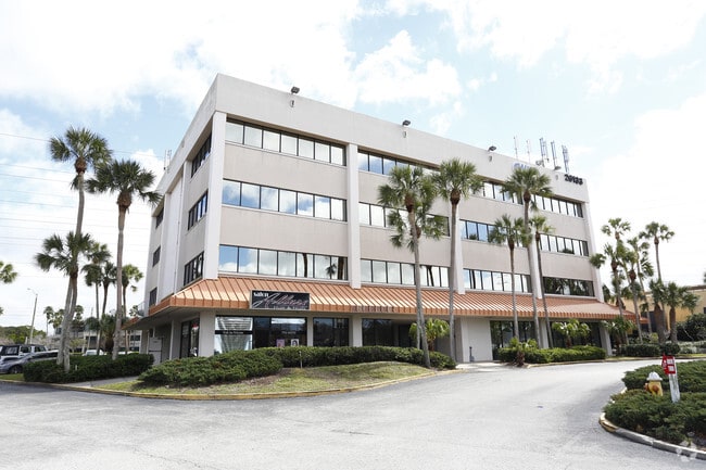
Property Record
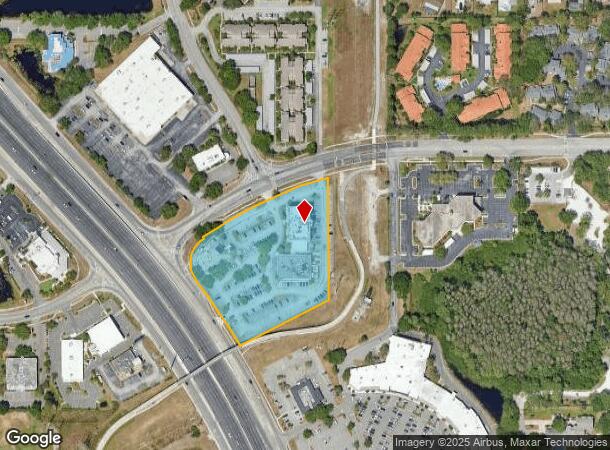
26133 Us Highway 19 N, Clearwater, FL 33763
Current Lease Availabilities
NEARBY LISTINGS FOR SALE OR LEASE
Property Detail
26133 Us Highway 19 N
31-28-16-00000-110-0700
From Ne Sec Cor Th S
Officebuilding
FROM NE SEC COR TH S 539.44FT FOR POB TH S 421.83FT TH S63DW 346.38FT TH NLY ALG US HWY 19 261.79FT TH CUR RT RAD 100 FT ARC 164.72FT TH N32DW 5 FT TH ELY ALG R/W 484.75 FT TO POB CONT 4.19AC(C)
X
Pinellas
12103C0088G
Florida
2024
4.18 AC
2025
North Pinellas
026813
Tampa/St Petersburg
48,194 SF
Tampa-St. Petersburg-Clearwater, FL
DEMOGRAPHICS near 26133 Us Highway 19 N
1 Mile
3 Mile
5 Mile
2024 Total Population
12,830
101,319
229,155
2029 Population
12,986
101,295
229,701
Pop Growth 2024-2029
+ 1.22%
(0.02%)
+ 0.24%
Average Age
53
48
47
2024 Total Households
6,782
47,058
104,153
HH Growth 2024-2029
+ 1.09%
(0.21%)
+ 0.16%
Median Household Inc
$51,346
$60,063
$59,522
Avg Household Size
1.90
2.10
2.10
2024 Avg HH Vehicles
1.00
2.00
2.00
Median Home Value
$176,623
$270,115
$280,539
Median Year Built
1979
1979
1979
Nearby Places
Map Layers
Map Styles
 Street
 Aerial
- Restaurants
- Banks
- Shops
- Fitness
- Groceries
PUBLIC TRANSPORTATION
AIRPORT
St Pete-Clearwater International
DRIVE
WALK
Distance
St Pete-Clearwater International
27 min
13.1 mi
Tampa International
DRIVE
WALK
Distance
Tampa International
30 min
17.4 mi
Freight Ports
Port of Tampa Bay
DRIVE
WALK
Distance
Port of Tampa Bay
43 min
25.8 mi
Nearby Properties
Address
Land Use
TOTAL SIZE
Lot Size
Zoning
Address
Land Use
TOTAL SIZE
Lot Size
Zoning
661,982 SF
19.26 AC
Address
Land Use
TOTAL SIZE
Lot Size
Zoning
675,202 SF
43.24 AC
Address
Land Use
TOTAL SIZE
Lot Size
Zoning
724,220 SF
22.95 AC
Address
Land Use
TOTAL SIZE
Lot Size
Zoning
435,202 SF
9.80 AC
R3
Address
Land Use
TOTAL SIZE
Lot Size
Zoning
460,041 SF
44.28 AC
Address
Land Use
TOTAL SIZE
Lot Size
Zoning
356,262 SF
15.48 AC
Address
Land Use
TOTAL SIZE
Lot Size
Zoning
167,201 SF
63.11 AC
AE
Address
Land Use
TOTAL SIZE
Lot Size
Zoning
406,729 SF
29.79 AC
CP1
Address
Land Use
TOTAL SIZE
Lot Size
Zoning
412,099 SF
49.21 AC
Address
Land Use
TOTAL SIZE
Lot Size
Zoning
171,150 SF
17.58 AC
Address
Land Use
TOTAL SIZE
Lot Size
Zoning
326,008 SF
53.12 AC
Address
Land Use
TOTAL SIZE
Lot Size
Zoning
662,010 SF
33.76 AC
Address
Land Use
TOTAL SIZE
Lot Size
Zoning
236,972 SF
19.07 AC
Address
Land Use
TOTAL SIZE
Lot Size
Zoning
492,747 SF
19.89 AC
Address
Land Use
TOTAL SIZE
Lot Size
Zoning
321,395 SF
25.22 AC
Address
Land Use
TOTAL SIZE
Lot Size
Zoning
239,340 SF
17.27 AC
Address
Land Use
TOTAL SIZE
Lot Size
Zoning
258,472 SF
18.23 AC
Address
Land Use
TOTAL SIZE
Lot Size
Zoning
251,016 SF
10.10 AC
AE
Address
Land Use
TOTAL SIZE
Lot Size
Zoning
284,000 SF
36.09 AC
Address
Land Use
TOTAL SIZE
Lot Size
Zoning
226,562 SF
11.08 AC
Address
Land Use
TOTAL SIZE
Lot Size
Zoning
215,081 SF
16.60 AC
Address
Land Use
TOTAL SIZE
Lot Size
Zoning
208,637 SF
16.83 AC
M1
Address
Land Use
TOTAL SIZE
Lot Size
Zoning
160,827 SF
20.22 AC
AE
Address
Land Use
TOTAL SIZE
Lot Size
Zoning
367,503 SF
20.34 AC
M2
Address
Land Use
TOTAL SIZE
Lot Size
Zoning
176,724 SF
10.92 AC
Address
Land Use
TOTAL SIZE
Lot Size
Zoning
241,170 SF
17.23 AC
Address
Land Use
TOTAL SIZE
Lot Size
Zoning
181,169 SF
21.90 AC
AE
Address
Land Use
TOTAL SIZE
Lot Size
Zoning
53,208 SF
38.71 AC
Address
Land Use
TOTAL SIZE
Lot Size
Zoning
131,291 SF
4.24 AC
Address
Land Use
TOTAL SIZE
Lot Size
Zoning
161,404 SF
18.48 AC
CP2
The World's #1 Commercial Real Estate Marketplace
Connect with us
© 2025 CoStar Group
The information above has been obtained from sources believed reliable. While we do not doubt its accuracy we have not verified it and make no guarantee, warranty or representation about it. It is your responsibility to independently confirm its accuracy and completeness. Any projections, opinions, assumptions, or estimates used are for example only and do not represent the current or future performance of the property. The value of this transaction to you depends on tax and other factors which should be evaluated by your tax, financial, and legal advisors. You and your advisors should conduct a careful, independent investigation of the property to determine to your satisfaction the suitability of the property for your needs.