Property Record
24821 Chrisanta Dr, Mission Viejo, CA 92691


NEARBY LISTINGS FOR SALE OR LEASE
-
-
View all Mission Viejo listings for sale on LoopNet.com
Property Detail
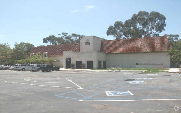
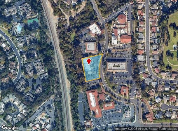
24821 Chrisanta Dr
Anaheim-Santa Ana-Irvine, CA
Parcel Map 84-111
784-502-16
P BK 193 PG 46 PAR 3
Commercialnec
Orange
X
California
06059C0431J
3
2024
1.10 AC
2025
Mission Viejo
032003
Orange County (California)
11,152 SF
DEMOGRAPHICS near 24821 Chrisanta Dr
1 Mile
3 Mile
5 Mile
2024 Total Population
16,253
154,823
333,740
2029 Population
15,967
152,826
329,141
Pop Growth 2024-2029
(1.76%)
(1.29%)
(1.38%)
Average Age
44
45
43
2024 Total Households
5,087
58,730
125,187
HH Growth 2024-2029
(1.91%)
(1.13%)
(1.28%)
Median Household Inc
$155,654
$106,252
$117,879
Avg Household Size
2.90
2.50
2.60
2024 Avg HH Vehicles
3.00
2.00
2.00
Median Home Value
$783,192
$729,988
$768,529
Median Year Built
1968
1977
1984
Nearby Places
Map Layers
Map Styles
 Street
 Aerial
- Restaurants
- Banks
- Shops
- Fitness
- Groceries
PUBLIC TRANSPORTATION
COMMUTER RAIL
Laguna Niguel/Mission Viejo (Inland Empire-Orange County Line - Southern California Regional Rail Authority (Metrolink), Orange County Line - Southern California Regional Rail Authority (Metrolink))
DRIVE
WALK
Distance
Laguna Niguel/Mission Viejo (Inland Empire-Orange County Line - Southern California Regional Rail Authority (Metrolink), Orange County Line - Southern California Regional Rail Authority (Metrolink))
8 min
4.8 mi
Irvine (Inland Empire-Orange County Line - Southern California Regional Rail Authority (Metrolink), Orange County Line - Southern California Regional Rail Authority (Metrolink))
DRIVE
WALK
Distance
Irvine (Inland Empire-Orange County Line - Southern California Regional Rail Authority (Metrolink), Orange County Line - Southern California Regional Rail Authority (Metrolink))
10 min
6.4 mi
AIRPORT
John Wayne/Orange County
DRIVE
WALK
Distance
John Wayne/Orange County
19 min
14.9 mi
Long Beach (Daugherty Field)
DRIVE
WALK
Distance
Long Beach (Daugherty Field)
43 min
35.0 mi
Ontario International
DRIVE
WALK
Distance
Ontario International
58 min
43.6 mi
Freight Ports
Port of Long Beach
DRIVE
WALK
Distance
Port of Long Beach
49 min
34.6 mi
Nearby Properties
Address
Land Use
TOTAL SIZE
Lot Size
Zoning
Address
Land Use
TOTAL SIZE
Lot Size
Zoning
104,707 SF
6.97 AC
RC
Address
Land Use
TOTAL SIZE
Lot Size
Zoning
Address
Land Use
TOTAL SIZE
Lot Size
Zoning
602,904 SF
22.10 AC
Address
Land Use
TOTAL SIZE
Lot Size
Zoning
Address
Land Use
TOTAL SIZE
Lot Size
Zoning
Address
Land Use
TOTAL SIZE
Lot Size
Zoning
21.92 AC
Address
Land Use
TOTAL SIZE
Lot Size
Zoning
Address
Land Use
TOTAL SIZE
Lot Size
Zoning
28,700 SF
3.35 AC
Address
Land Use
TOTAL SIZE
Lot Size
Zoning
133,600 SF
2.62 AC
Address
Land Use
TOTAL SIZE
Lot Size
Zoning
Address
Land Use
TOTAL SIZE
Lot Size
Zoning
120,746 SF
1.17 AC
Address
Land Use
TOTAL SIZE
Lot Size
Zoning
17.93 AC
Address
Land Use
TOTAL SIZE
Lot Size
Zoning
165,662 SF
8.60 AC
Address
Land Use
TOTAL SIZE
Lot Size
Zoning
Address
Land Use
TOTAL SIZE
Lot Size
Zoning
Address
Land Use
TOTAL SIZE
Lot Size
Zoning
Address
Land Use
TOTAL SIZE
Lot Size
Zoning
245,482 SF
19.72 AC
Address
Land Use
TOTAL SIZE
Lot Size
Zoning
267,463 SF
19.51 AC
Address
Land Use
TOTAL SIZE
Lot Size
Zoning
303,540 SF
26.89 AC
BP
Address
Land Use
TOTAL SIZE
Lot Size
Zoning
Address
Land Use
TOTAL SIZE
Lot Size
Zoning
Address
Land Use
TOTAL SIZE
Lot Size
Zoning
157,676 SF
12.23 AC
Address
Land Use
TOTAL SIZE
Lot Size
Zoning
123,057 SF
7.45 AC
Address
Land Use
TOTAL SIZE
Lot Size
Zoning
128,454 SF
9.31 AC
Address
Land Use
TOTAL SIZE
Lot Size
Zoning
Address
Land Use
TOTAL SIZE
Lot Size
Zoning
210,765 SF
16.01 AC
Address
Land Use
TOTAL SIZE
Lot Size
Zoning
Address
Land Use
TOTAL SIZE
Lot Size
Zoning
176,449 SF
15.43 AC
Address
Land Use
TOTAL SIZE
Lot Size
Zoning
82,974 SF
4.40 AC
Address
Land Use
TOTAL SIZE
Lot Size
Zoning
295,405 SF
13.14 AC
The World's #1 Commercial Real Estate Marketplace
Connect with us
© 2026 CoStar Group
The information above has been obtained from sources believed reliable. While we do not doubt its accuracy we have not verified it and make no guarantee, warranty or representation about it. It is your responsibility to independently confirm its accuracy and completeness. Any projections, opinions, assumptions, or estimates used are for example only and do not represent the current or future performance of the property. The value of this transaction to you depends on tax and other factors which should be evaluated by your tax, financial, and legal advisors. You and your advisors should conduct a careful, independent investigation of the property to determine to your satisfaction the suitability of the property for your needs.