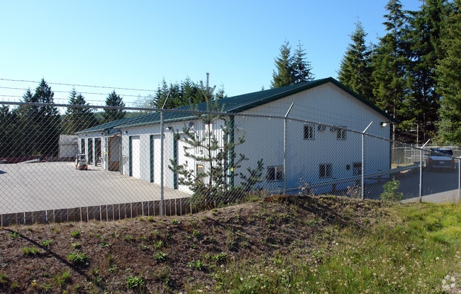
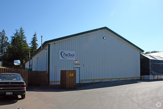
Property Record
26139 United Rd Ne, Kingston, WA 98346

NEARBY LISTINGS FOR SALE OR LEASE
-
-
View all Kingston listings for sale on LoopNet.com
Property Detail
26139 United Rd Ne
Bremerton-Silverdale-Port Orchard, WA
Short Subdivision #7397
292702-3-078-2001
RESULTANT PARCEL 1 OF BOUNDARY LINE ADJUSTMENT RECORDED UNDER AUDITORS FILE NO. 201702100243, RECORDS OF KITSAP COUNTY, WASHINGTON, BEING A PORTION OF LOT A, SHORT PLAT NO. 7397, AS RECORDED UNDER AUDITORS FILE NO. 201112050259, BEING A PORTION OF TH
Commercialnec
Kitsap
A
Washington
53031C0965C
a
2025
4.11 AC
2026
North Kitsap County
090102
Bremerton/Silverdale
22,400 SF
DEMOGRAPHICS near 26139 United Rd Ne
1 Mile
3 Mile
5 Mile
2024 Total Population
1,089
5,642
28,087
2029 Population
1,082
5,597
27,906
Pop Growth 2024-2029
(0.64%)
(0.80%)
(0.64%)
Average Age
42
43
43
2024 Total Households
393
2,109
10,925
HH Growth 2024-2029
(0.76%)
(0.76%)
(0.70%)
Median Household Inc
$114,930
$102,117
$97,707
Avg Household Size
2.70
2.60
2.50
2024 Avg HH Vehicles
3.00
2.00
2.00
Median Home Value
$533,626
$539,746
$549,155
Median Year Built
1980
1986
1990
Nearby Places
Map Layers
Map Styles
 Street
 Aerial
- Restaurants
- Banks
- Shops
- Fitness
- Groceries
PUBLIC TRANSPORTATION
AIRPORT
Seattle Paine Field International
DRIVE
WALK
Distance
Seattle Paine Field International
58 min
21.5 mi
Seattle-Tacoma International
DRIVE
WALK
Distance
Seattle-Tacoma International
83 min
41.3 mi
Freight Ports
Port of Everett
DRIVE
WALK
Distance
Port of Everett
69 min
29.5 mi
SALE & LEASE HISTORY
LISTING DATE
SALE/LEASE

Jan 10, 2018
For Sale
Nearby Properties
Address
Land Use
TOTAL SIZE
Lot Size
Zoning
Address
Land Use
TOTAL SIZE
Lot Size
Zoning
1,510 SF
5.15 AC
REC
Address
Land Use
TOTAL SIZE
Lot Size
Zoning
41,892 SF
4.58 AC
NC
Address
Land Use
TOTAL SIZE
Lot Size
Zoning
18,187 SF
2.16 AC
NC
Address
Land Use
TOTAL SIZE
Lot Size
Zoning
9,933 SF
0.98 AC
NC
Address
Land Use
TOTAL SIZE
Lot Size
Zoning
57,386 SF
7.70 AC
REC
Address
Land Use
TOTAL SIZE
Lot Size
Zoning
9,750 SF
1.11 AC
NC
Address
Land Use
TOTAL SIZE
Lot Size
Zoning
9,064 SF
15.07 AC
RR
Address
Land Use
TOTAL SIZE
Lot Size
Zoning
6,450 SF
0.90 AC
NC
Address
Land Use
TOTAL SIZE
Lot Size
Zoning
10,560 SF
0.85 AC
REC
Address
Land Use
TOTAL SIZE
Lot Size
Zoning
5,327 SF
31.03 AC
RP
Address
Land Use
TOTAL SIZE
Lot Size
Zoning
21,600 SF
4.86 AC
RP
Address
Land Use
TOTAL SIZE
Lot Size
Zoning
4,317 SF
2 AC
RP
Address
Land Use
TOTAL SIZE
Lot Size
Zoning
4,200 SF
1.32 AC
NC
Address
Land Use
TOTAL SIZE
Lot Size
Zoning
5.03 AC
REC
Address
Land Use
TOTAL SIZE
Lot Size
Zoning
3,560 SF
1.78 AC
REC
Address
Land Use
TOTAL SIZE
Lot Size
Zoning
13,600 SF
1.43 AC
REC
Address
Land Use
TOTAL SIZE
Lot Size
Zoning
1,980 SF
0.85 AC
NC
Address
Land Use
TOTAL SIZE
Lot Size
Zoning
16,000 SF
2.64 AC
REC
Address
Land Use
TOTAL SIZE
Lot Size
Zoning
14,400 SF
1.25 AC
REC
Address
Land Use
TOTAL SIZE
Lot Size
Zoning
17,034 SF
1.93 AC
RP
Address
Land Use
TOTAL SIZE
Lot Size
Zoning
1,104 SF
2.50 AC
RR
Address
Land Use
TOTAL SIZE
Lot Size
Zoning
7,264 SF
5 AC
RR
Address
Land Use
TOTAL SIZE
Lot Size
Zoning
9,808 SF
1.24 AC
REC
Address
Land Use
TOTAL SIZE
Lot Size
Zoning
5,929 SF
1.70 AC
NC
Address
Land Use
TOTAL SIZE
Lot Size
Zoning
1,600 SF
8.96 AC
REC
Address
Land Use
TOTAL SIZE
Lot Size
Zoning
14,520 SF
2.63 AC
RI
Address
Land Use
TOTAL SIZE
Lot Size
Zoning
9,600 SF
0.78 AC
REC
Address
Land Use
TOTAL SIZE
Lot Size
Zoning
10,800 SF
0.47 AC
REC
Address
Land Use
TOTAL SIZE
Lot Size
Zoning
2,983 SF
4.47 AC
RP
The World's #1 Commercial Real Estate Marketplace
Connect with us
© 2026 CoStar Group
The information above has been obtained from sources believed reliable. While we do not doubt its accuracy we have not verified it and make no guarantee, warranty or representation about it. It is your responsibility to independently confirm its accuracy and completeness. Any projections, opinions, assumptions, or estimates used are for example only and do not represent the current or future performance of the property. The value of this transaction to you depends on tax and other factors which should be evaluated by your tax, financial, and legal advisors. You and your advisors should conduct a careful, independent investigation of the property to determine to your satisfaction the suitability of the property for your needs.