Property Record
2615 Citizens Pky, Selma, AL 36701
NEARBY LISTINGS FOR SALE OR LEASE
Property Detail
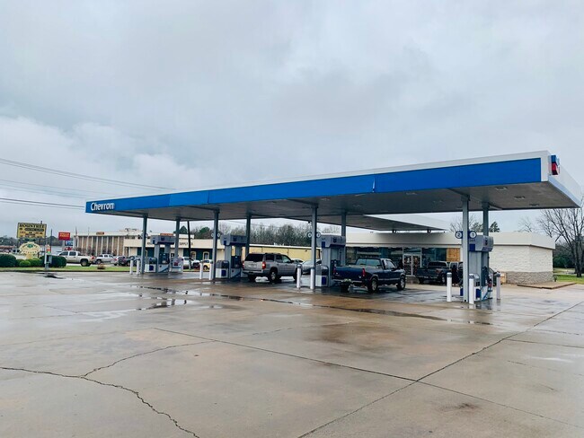
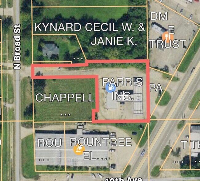
2615 Citizens Pky
11-06-24-2-001-024.0000
Highland View S/D
Conveniencestore
PT TRACT 16 & N/2 OF ALLEY NOW VACATED IN DB-1170 PG-602 HIGHLAND VIEW S/D DB-1297 PG-71 S24 T17N R10E
X
Dallas
01047C0192E
Alabama
2024
0.85 AC
2024
Alabama South Area
956300
Other Market Areas
2,520 SF
Selma, AL
DEMOGRAPHICS near 2615 Citizens Pky
1 Mile
3 Mile
5 Mile
2024 Total Population
4,503
16,987
23,997
2029 Population
4,097
16,033
22,538
Pop Growth 2024-2029
(9.02%)
(5.62%)
(6.08%)
Average Age
39
40
40
2024 Total Households
1,927
7,153
10,026
HH Growth 2024-2029
(8.46%)
(5.10%)
(5.51%)
Median Household Inc
$24,670
$28,771
$32,701
Avg Household Size
2.20
2.30
2.30
2024 Avg HH Vehicles
2.00
2.00
2.00
Median Home Value
$72,628
$83,079
$87,708
Median Year Built
1968
1968
1970
Nearby Places
Map Layers
Map Styles
 Street
 Aerial
- Restaurants
- Banks
- Shops
- Fitness
- Groceries
SALE & LEASE HISTORY
LISTING DATE
SALE/LEASE

Mar 17, 2020
For Sale
Nearby Properties
Address
Land Use
TOTAL SIZE
Lot Size
Zoning
Address
Land Use
TOTAL SIZE
Lot Size
Zoning
230,750 SF
7.34 AC
C
Address
Land Use
TOTAL SIZE
Lot Size
Zoning
180,393 SF
19.10 AC
C
Address
Land Use
TOTAL SIZE
Lot Size
Zoning
87,391 SF
2.66 AC
Address
Land Use
TOTAL SIZE
Lot Size
Zoning
27,185 SF
1.96 AC
C
Address
Land Use
TOTAL SIZE
Lot Size
Zoning
42,285 SF
0.53 AC
C
Address
Land Use
TOTAL SIZE
Lot Size
Zoning
112,856 SF
11.02 AC
I
Address
Land Use
TOTAL SIZE
Lot Size
Zoning
44,944 SF
0.17 AC
N
Address
Land Use
TOTAL SIZE
Lot Size
Zoning
18,260 SF
10 AC
N
Address
Land Use
TOTAL SIZE
Lot Size
Zoning
145,338 SF
6.82 AC
C
Address
Land Use
TOTAL SIZE
Lot Size
Zoning
156,542 SF
46 AC
C
Address
Land Use
TOTAL SIZE
Lot Size
Zoning
4,814 SF
6 AC
M
Address
Land Use
TOTAL SIZE
Lot Size
Zoning
6,650 SF
10 AC
O
Address
Land Use
TOTAL SIZE
Lot Size
Zoning
64,854 SF
2.31 AC
O
Address
Land Use
TOTAL SIZE
Lot Size
Zoning
6,374 SF
3.18 AC
S
Address
Land Use
TOTAL SIZE
Lot Size
Zoning
62,913 SF
0.92 AC
Address
Land Use
TOTAL SIZE
Lot Size
Zoning
7,788 SF
8 AC
M
Address
Land Use
TOTAL SIZE
Lot Size
Zoning
1,494 SF
12 AC
S
Address
Land Use
TOTAL SIZE
Lot Size
Zoning
7,606 SF
4.80 AC
C
Address
Land Use
TOTAL SIZE
Lot Size
Zoning
53,100 SF
7.15 AC
O
Address
Land Use
TOTAL SIZE
Lot Size
Zoning
34,495 SF
5.68 AC
N
Address
Land Use
TOTAL SIZE
Lot Size
Zoning
8,034 SF
22 AC
S
Address
Land Use
TOTAL SIZE
Lot Size
Zoning
2,941 SF
22.98 AC
C
Address
Land Use
TOTAL SIZE
Lot Size
Zoning
2,608 SF
10 AC
M
Address
Land Use
TOTAL SIZE
Lot Size
Zoning
27,693 SF
1.22 AC
O
Address
Land Use
TOTAL SIZE
Lot Size
Zoning
12,051 SF
1.04 AC
C
Address
Land Use
TOTAL SIZE
Lot Size
Zoning
50,267 SF
5.77 AC
C
Address
Land Use
TOTAL SIZE
Lot Size
Zoning
24,657 SF
4.23 AC
N
Address
Land Use
TOTAL SIZE
Lot Size
Zoning
18,248 SF
16.02 AC
N
Address
Land Use
TOTAL SIZE
Lot Size
Zoning
4,002 SF
10 AC
S
Address
Land Use
TOTAL SIZE
Lot Size
Zoning
74,205 SF
2.50 AC
O
The World's #1 Commercial Real Estate Marketplace
Connect with us
© 2026 CoStar Group
The information above has been obtained from sources believed reliable. While we do not doubt its accuracy we have not verified it and make no guarantee, warranty or representation about it. It is your responsibility to independently confirm its accuracy and completeness. Any projections, opinions, assumptions, or estimates used are for example only and do not represent the current or future performance of the property. The value of this transaction to you depends on tax and other factors which should be evaluated by your tax, financial, and legal advisors. You and your advisors should conduct a careful, independent investigation of the property to determine to your satisfaction the suitability of the property for your needs.