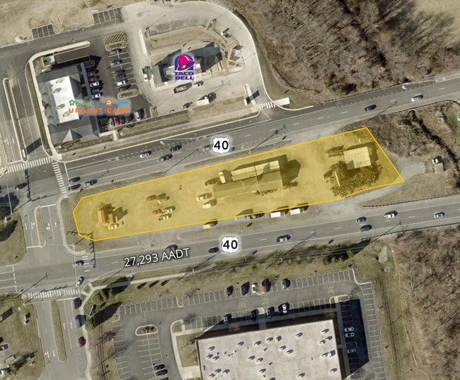
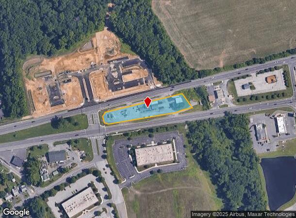
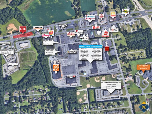
Property Record
2615 Pulaski Hwy, Newark, DE 19702
Current Lease Availabilities
NEARBY LISTINGS FOR SALE OR LEASE
Property Detail
2615 Pulaski Hwy
Warehouse
New Castle
X
Delaware
10003C0225L
1.18 AC
2024
South New Castle County
2024
Philadelphia
014814
Philadelphia-Camden-Wilmington, PA-NJ-DE-MD
2,450 SF
11-026.00-050
DEMOGRAPHICS near 2615 Pulaski Hwy
1 Mile
3 Mile
5 Mile
2024 Total Population
2,947
40,789
119,335
2029 Population
3,036
41,474
121,613
Pop Growth 2024-2029
+ 3.02%
+ 1.68%
+ 1.91%
Average Age
42
40
39
2024 Total Households
1,065
14,935
44,214
HH Growth 2024-2029
+ 3.19%
+ 1.75%
+ 2.01%
Median Household Inc
$115,495
$89,031
$78,448
Avg Household Size
2.70
2.70
2.60
2024 Avg HH Vehicles
2.00
2.00
2.00
Median Home Value
$347,743
$314,445
$294,694
Median Year Built
1995
1992
1991
Nearby Places
Map Layers
Map Styles
 Street
 Aerial
- Restaurants
- Banks
- Shops
- Fitness
- Groceries
PUBLIC TRANSPORTATION
COMMUTER RAIL
Newark (R2 - Southeastern Pennsylvania Transportation Authority Regional Rail (SEPTA Regional Rail))
DRIVE
WALK
Distance
Newark (R2 - Southeastern Pennsylvania Transportation Authority Regional Rail (SEPTA Regional Rail))
9 min
5.5 mi
AIRPORT
Philadelphia International
DRIVE
WALK
Distance
Philadelphia International
50 min
37.4 mi
Freight Ports
Port Newark Container Terminal
DRIVE
WALK
Distance
Port Newark Container Terminal
24 min
13.0 mi
Nearby Properties
Address
Land Use
TOTAL SIZE
Lot Size
Zoning
Address
Land Use
TOTAL SIZE
Lot Size
Zoning
766,520 SF
69.52 AC
BI
Address
Land Use
TOTAL SIZE
Lot Size
Zoning
200,880 SF
49.83 AC
R3
Address
Land Use
TOTAL SIZE
Lot Size
Zoning
263,500 SF
15.28 AC
BI
Address
Land Use
TOTAL SIZE
Lot Size
Zoning
266,818 SF
64.16 AC
BP
Address
Land Use
TOTAL SIZE
Lot Size
Zoning
62,900 SF
30.54 AC
S
Address
Land Use
TOTAL SIZE
Lot Size
Zoning
82,688 SF
11.30 AC
BI
Address
Land Use
TOTAL SIZE
Lot Size
Zoning
267,840 SF
20.35 AC
BI
Address
Land Use
TOTAL SIZE
Lot Size
Zoning
161,018 SF
97.88 AC
OR
Address
Land Use
TOTAL SIZE
Lot Size
Zoning
226,878 SF
73.68 AC
CR
Address
Land Use
TOTAL SIZE
Lot Size
Zoning
205,955 SF
24.91 AC
BI
Address
Land Use
TOTAL SIZE
Lot Size
Zoning
930 SF
52.69 AC
S
Address
Land Use
TOTAL SIZE
Lot Size
Zoning
11,200 SF
64.19 AC
BI
Address
Land Use
TOTAL SIZE
Lot Size
Zoning
385,350 SF
43.51 AC
OR
Address
Land Use
TOTAL SIZE
Lot Size
Zoning
15.86 AC
R3
Address
Land Use
TOTAL SIZE
Lot Size
Zoning
137,330 SF
14.11 AC
C2
Address
Land Use
TOTAL SIZE
Lot Size
Zoning
51,560 SF
4.57 AC
OR
Address
Land Use
TOTAL SIZE
Lot Size
Zoning
392,955 SF
16.87 AC
NCAP
Address
Land Use
TOTAL SIZE
Lot Size
Zoning
293,376 SF
149.74 AC
I
Address
Land Use
TOTAL SIZE
Lot Size
Zoning
153,556 SF
30.12 AC
OR
Address
Land Use
TOTAL SIZE
Lot Size
Zoning
151,156 SF
14.93 AC
CR
Address
Land Use
TOTAL SIZE
Lot Size
Zoning
72,182 SF
17 AC
R2
Address
Land Use
TOTAL SIZE
Lot Size
Zoning
55,200 SF
11.72 AC
ON
Address
Land Use
TOTAL SIZE
Lot Size
Zoning
20,250 SF
71.16 AC
S
Address
Land Use
TOTAL SIZE
Lot Size
Zoning
14,735 SF
1.58 AC
BG
Address
Land Use
TOTAL SIZE
Lot Size
Zoning
10,244 SF
7.38 AC
C2
Address
Land Use
TOTAL SIZE
Lot Size
Zoning
10,244 SF
6.91 AC
C2
Address
Land Use
TOTAL SIZE
Lot Size
Zoning
50,720 SF
7.84 AC
C2
Address
Land Use
TOTAL SIZE
Lot Size
Zoning
186,610 SF
15.16 AC
BP
Address
Land Use
TOTAL SIZE
Lot Size
Zoning
9,660 SF
16.90 AC
BP
Address
Land Use
TOTAL SIZE
Lot Size
Zoning
17,916 SF
3.76 AC
C2
The World's #1 Commercial Real Estate Marketplace
Connect with us
© 2026 CoStar Group
The information above has been obtained from sources believed reliable. While we do not doubt its accuracy we have not verified it and make no guarantee, warranty or representation about it. It is your responsibility to independently confirm its accuracy and completeness. Any projections, opinions, assumptions, or estimates used are for example only and do not represent the current or future performance of the property. The value of this transaction to you depends on tax and other factors which should be evaluated by your tax, financial, and legal advisors. You and your advisors should conduct a careful, independent investigation of the property to determine to your satisfaction the suitability of the property for your needs.