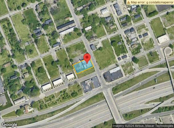
Property Record
2615 Rosa Parks Blvd, Detroit, MI 48216
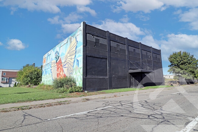

This Property Is For Sale
NEARBY LISTINGS FOR SALE OR LEASE
Property Detail
2615 Rosa Parks Blvd
08-008221
Plat Of Cabacier Farm
Loftbuilding
W TWELFTH 24&23 BLK 4 PLAT OF CABACIER FARM L45 P180 PLATS, W C R 8/28 100 X 187.50
X
Wayne
26163C0280E
Michigan
2025
0.43 AC
2025
Detroit West
521500
Detroit
13,177 SF
Detroit-Warren-Dearborn, MI
DEMOGRAPHICS near 2615 Rosa Parks Blvd
1 Mile
3 Mile
5 Mile
2024 Total Population
10,308
101,689
259,752
2029 Population
10,082
100,869
258,230
Pop Growth 2024-2029
(2.19%)
(0.81%)
(0.59%)
Average Age
38
38
37
2024 Total Households
5,211
47,761
107,408
HH Growth 2024-2029
(2.15%)
(0.92%)
(0.34%)
Median Household Inc
$32,725
$37,409
$34,795
Avg Household Size
1.80
1.90
2.30
2024 Avg HH Vehicles
1.00
1.00
1.00
Median Home Value
$274,811
$125,826
$97,856
Median Year Built
1958
1953
1948
Nearby Places
Map Layers
Map Styles
 Street
 Aerial
- Restaurants
- Banks
- Shops
- Fitness
- Groceries
PUBLIC TRANSPORTATION
COMMUTER RAIL
DRIVE
WALK
Distance
7 min
3.1 mi
DRIVE
WALK
Distance
14 min
5.2 mi
AIRPORT
Windsor International
DRIVE
WALK
Distance
Windsor International
28 min
13.1 mi
Detroit Metro Wayne County
DRIVE
WALK
Distance
Detroit Metro Wayne County
33 min
21.8 mi
Freight Ports
DRIVE
WALK
Distance
74 min
59.7 mi
Nearby Properties
Address
Land Use
TOTAL SIZE
Lot Size
Zoning
Address
Land Use
TOTAL SIZE
Lot Size
Zoning
3,032,363 SF
24.24 AC
SD5
Address
Land Use
TOTAL SIZE
Lot Size
Zoning
6,112,830 SF
13.67 AC
PD
Address
Land Use
TOTAL SIZE
Lot Size
Zoning
409,438 SF
0.83 AC
B6
Address
Land Use
TOTAL SIZE
Lot Size
Zoning
1,409,416 SF
13.53 AC
R6
Address
Land Use
TOTAL SIZE
Lot Size
Zoning
1,553,311 SF
3.05 AC
SD5
Address
Land Use
TOTAL SIZE
Lot Size
Zoning
1,994,989 SF
4.97 AC
B5
Address
Land Use
TOTAL SIZE
Lot Size
Zoning
873,048 SF
7.70 AC
R6
Address
Land Use
TOTAL SIZE
Lot Size
Zoning
1,478,866 SF
2.88 AC
PCA
Address
Land Use
TOTAL SIZE
Lot Size
Zoning
1,017,009 SF
1.35 AC
R6
Address
Land Use
TOTAL SIZE
Lot Size
Zoning
848,598 SF
8.78 AC
SD5
Address
Land Use
TOTAL SIZE
Lot Size
Zoning
252,150 SF
2.46 AC
SD5
Address
Land Use
TOTAL SIZE
Lot Size
Zoning
185,300 SF
3.36 AC
SD5
Address
Land Use
TOTAL SIZE
Lot Size
Zoning
1,847,449 SF
13.85 AC
PD
Address
Land Use
TOTAL SIZE
Lot Size
Zoning
6,620 SF
9.43 AC
B6
Address
Land Use
TOTAL SIZE
Lot Size
Zoning
1,004,872 SF
1.05 AC
PCA
Address
Land Use
TOTAL SIZE
Lot Size
Zoning
720,653 SF
1.53 AC
PCA
Address
Land Use
TOTAL SIZE
Lot Size
Zoning
895,279 SF
3.58 AC
PCA
Address
Land Use
TOTAL SIZE
Lot Size
Zoning
1,149,710 SF
1.07 AC
B5
Address
Land Use
TOTAL SIZE
Lot Size
Zoning
503,688 SF
Address
Land Use
TOTAL SIZE
Lot Size
Zoning
919,213 SF
B5
Address
Land Use
TOTAL SIZE
Lot Size
Zoning
568,546 SF
B5
Address
Land Use
TOTAL SIZE
Lot Size
Zoning
874,160 SF
9.91 AC
R6
Address
Land Use
TOTAL SIZE
Lot Size
Zoning
520,897 SF
0.85 AC
Address
Land Use
TOTAL SIZE
Lot Size
Zoning
306,496 SF
1.91 AC
R6
Address
Land Use
TOTAL SIZE
Lot Size
Zoning
430,286 SF
1.14 AC
PCA
Address
Land Use
TOTAL SIZE
Lot Size
Zoning
437,558 SF
0.72 AC
Address
Land Use
TOTAL SIZE
Lot Size
Zoning
187,652 SF
Address
Land Use
TOTAL SIZE
Lot Size
Zoning
268,746 SF
B5
Address
Land Use
TOTAL SIZE
Lot Size
Zoning
576,286 SF
1.66 AC
B4
Address
Land Use
TOTAL SIZE
Lot Size
Zoning
167,719 SF
2.18 AC
SD5
The World's #1 Commercial Real Estate Marketplace
Connect with us
© 2026 CoStar Group
The information above has been obtained from sources believed reliable. While we do not doubt its accuracy we have not verified it and make no guarantee, warranty or representation about it. It is your responsibility to independently confirm its accuracy and completeness. Any projections, opinions, assumptions, or estimates used are for example only and do not represent the current or future performance of the property. The value of this transaction to you depends on tax and other factors which should be evaluated by your tax, financial, and legal advisors. You and your advisors should conduct a careful, independent investigation of the property to determine to your satisfaction the suitability of the property for your needs.