Property Record
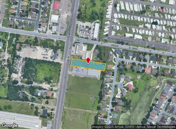
2615 Us Highway 281, Pharr, TX 78577
NEARBY LISTINGS FOR SALE OR LEASE
Property Detail
2615 Us Highway 281
McAllen/Edinburg/Pharr
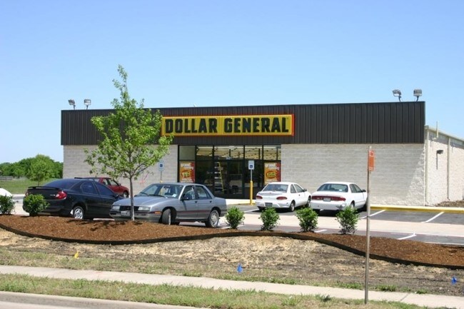
Pharr-Dollar General
McAllen-Edinburg-Mission, TX
PHARR-DOLLAR GENERAL LOT 2
P6322-00-000-0002-00
Hidalgo
Vacantlandnec
Texas
2024
2
2025
0.85 AC
021407
Pharr
DEMOGRAPHICS near 2615 Us Highway 281
1 Mile
3 Mile
5 Mile
2024 Total Population
11,972
75,274
194,121
2029 Population
13,329
80,356
205,715
Pop Growth 2024-2029
+ 11.33%
+ 6.75%
+ 5.97%
Average Age
37
35
35
2024 Total Households
4,007
23,396
59,809
HH Growth 2024-2029
+ 11.75%
+ 6.93%
+ 6.05%
Median Household Inc
$52,224
$45,262
$40,663
Avg Household Size
2.80
3.10
3.10
2024 Avg HH Vehicles
2.00
2.00
2.00
Median Home Value
$128,107
$115,205
$102,886
Median Year Built
2006
1999
1997
Nearby Places
Map Layers
Map Styles
 Street
 Aerial
- Restaurants
- Banks
- Shops
- Fitness
- Groceries
PUBLIC TRANSPORTATION
AIRPORT
McAllen International
DRIVE
WALK
Distance
McAllen International
10 min
5.0 mi
Freight Ports
Port of Brownsville
DRIVE
WALK
Distance
Port of Brownsville
67 min
58.9 mi
Nearby Properties
Address
Land Use
TOTAL SIZE
Lot Size
Zoning
Address
Land Use
TOTAL SIZE
Lot Size
Zoning
430,216 SF
18.66 AC
CO
Address
Land Use
TOTAL SIZE
Lot Size
Zoning
347,628 SF
13.03 AC
CO
Address
Land Use
TOTAL SIZE
Lot Size
Zoning
1 SF
24.90 AC
Address
Land Use
TOTAL SIZE
Lot Size
Zoning
390,048 SF
30.30 AC
Address
Land Use
TOTAL SIZE
Lot Size
Zoning
323,769 SF
62.11 AC
Address
Land Use
TOTAL SIZE
Lot Size
Zoning
2 SF
38 AC
RS
Address
Land Use
TOTAL SIZE
Lot Size
Zoning
216,315 SF
3.19 AC
CO
Address
Land Use
TOTAL SIZE
Lot Size
Zoning
175,594 SF
24.77 AC
Address
Land Use
TOTAL SIZE
Lot Size
Zoning
36.19 AC
Address
Land Use
TOTAL SIZE
Lot Size
Zoning
1 SF
39.94 AC
CO
Address
Land Use
TOTAL SIZE
Lot Size
Zoning
7.50 AC
Address
Land Use
TOTAL SIZE
Lot Size
Zoning
202,204 SF
19.43 AC
Address
Land Use
TOTAL SIZE
Lot Size
Zoning
115,998 SF
6.73 AC
Address
Land Use
TOTAL SIZE
Lot Size
Zoning
140,904 SF
33.98 AC
Address
Land Use
TOTAL SIZE
Lot Size
Zoning
123,548 SF
10.70 AC
Address
Land Use
TOTAL SIZE
Lot Size
Zoning
135,948 SF
2.87 AC
Address
Land Use
TOTAL SIZE
Lot Size
Zoning
84,335 SF
5.79 AC
CO
Address
Land Use
TOTAL SIZE
Lot Size
Zoning
2 SF
92.29 AC
CO
Address
Land Use
TOTAL SIZE
Lot Size
Zoning
13,632 SF
17 AC
Address
Land Use
TOTAL SIZE
Lot Size
Zoning
66,605 SF
10.05 AC
Address
Land Use
TOTAL SIZE
Lot Size
Zoning
19.09 AC
Address
Land Use
TOTAL SIZE
Lot Size
Zoning
208,104 SF
15.65 AC
Address
Land Use
TOTAL SIZE
Lot Size
Zoning
100,318 SF
3.65 AC
Address
Land Use
TOTAL SIZE
Lot Size
Zoning
143,400 SF
9.36 AC
Address
Land Use
TOTAL SIZE
Lot Size
Zoning
145,326 SF
7.14 AC
Address
Land Use
TOTAL SIZE
Lot Size
Zoning
123,200 SF
21.70 AC
Address
Land Use
TOTAL SIZE
Lot Size
Zoning
156,704 SF
7.06 AC
Address
Land Use
TOTAL SIZE
Lot Size
Zoning
29,172 SF
13.82 AC
Address
Land Use
TOTAL SIZE
Lot Size
Zoning
71,964 SF
2.22 AC
CO
Address
Land Use
TOTAL SIZE
Lot Size
Zoning
2 SF
22.11 AC
The World's #1 Commercial Real Estate Marketplace
Connect with us
© 2025 CoStar Group
The information above has been obtained from sources believed reliable. While we do not doubt its accuracy we have not verified it and make no guarantee, warranty or representation about it. It is your responsibility to independently confirm its accuracy and completeness. Any projections, opinions, assumptions, or estimates used are for example only and do not represent the current or future performance of the property. The value of this transaction to you depends on tax and other factors which should be evaluated by your tax, financial, and legal advisors. You and your advisors should conduct a careful, independent investigation of the property to determine to your satisfaction the suitability of the property for your needs.