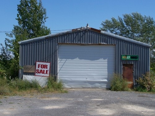
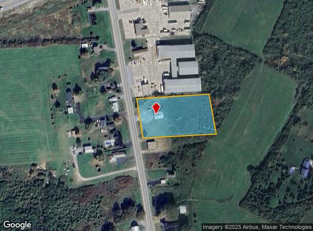
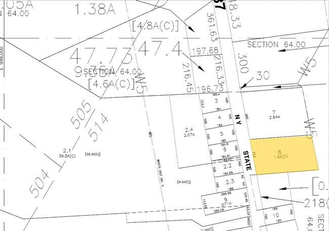
Property Record
26158 State Route 37, Watertown, NY 13601
NEARBY LISTINGS FOR SALE OR LEASE
-
-
View all Watertown listings for sale on LoopNet.com
Property Detail
26158 State Route 37
224889 64.18-1-46
Jefferson
Warehouse
New York
ARE
46.000
36045C0517G
1.90 AC
2025
Jefferson County
2024
Syracuse
060602
Watertown-Fort Drum, NY
1,728 SF
DEMOGRAPHICS near 26158 State Route 37
1 Mile
3 Mile
5 Mile
2024 Total Population
488
4,548
30,655
2029 Population
473
4,447
29,778
Pop Growth 2024-2029
(3.07%)
(2.22%)
(2.86%)
Average Age
35
33
32
2024 Total Households
182
1,854
11,266
HH Growth 2024-2029
(3.30%)
(2.48%)
(3.13%)
Median Household Inc
$62,500
$58,862
$53,445
Avg Household Size
2.50
2.40
2.40
2024 Avg HH Vehicles
2.00
2.00
1.00
Median Home Value
$182,954
$185,509
$147,427
Median Year Built
1980
1986
1981
Nearby Places
- Restaurants
- Banks
- Shops
- Fitness
- Groceries
Nearby Properties
Address
Land Use
TOTAL SIZE
Lot Size
Zoning
Address
Land Use
TOTAL SIZE
Lot Size
Zoning
10,848 SF
89.80 AC
B
Address
Land Use
TOTAL SIZE
Lot Size
Zoning
3,852 SF
60.50 AC
PD
Address
Land Use
TOTAL SIZE
Lot Size
Zoning
10,944 SF
82.39 AC
PD
Address
Land Use
TOTAL SIZE
Lot Size
Zoning
77,688 SF
53.15 AC
AR
Address
Land Use
TOTAL SIZE
Lot Size
Zoning
203,818 SF
23.37 AC
B
Address
Land Use
TOTAL SIZE
Lot Size
Zoning
27,296 SF
81.58 AC
99
Address
Land Use
TOTAL SIZE
Lot Size
Zoning
10,559 SF
1.11 AC
99
Address
Land Use
TOTAL SIZE
Lot Size
Zoning
35,900 SF
5.43 AC
B-
Address
Land Use
TOTAL SIZE
Lot Size
Zoning
58,212 SF
4.15 AC
B-
Address
Land Use
TOTAL SIZE
Lot Size
Zoning
22,400 SF
46.32 AC
Address
Land Use
TOTAL SIZE
Lot Size
Zoning
3,180 SF
28.60 AC
99
Address
Land Use
TOTAL SIZE
Lot Size
Zoning
8,714 SF
195.76 AC
99
Address
Land Use
TOTAL SIZE
Lot Size
Zoning
4,125 SF
5.05 AC
99
Address
Land Use
TOTAL SIZE
Lot Size
Zoning
10,725 SF
4.20 AC
99
Address
Land Use
TOTAL SIZE
Lot Size
Zoning
14,000 SF
2.64 AC
99
Address
Land Use
TOTAL SIZE
Lot Size
Zoning
3,948 SF
5.56 AC
99
Address
Land Use
TOTAL SIZE
Lot Size
Zoning
2,880 SF
1.95 AC
99
Address
Land Use
TOTAL SIZE
Lot Size
Zoning
4,200 SF
1.36 AC
B
Address
Land Use
TOTAL SIZE
Lot Size
Zoning
72.30 AC
Address
Land Use
TOTAL SIZE
Lot Size
Zoning
18,000 SF
46.30 AC
Address
Land Use
TOTAL SIZE
Lot Size
Zoning
30,000 SF
3.68 AC
99
Address
Land Use
TOTAL SIZE
Lot Size
Zoning
Address
Land Use
TOTAL SIZE
Lot Size
Zoning
23,750 SF
2.67 AC
99
Address
Land Use
TOTAL SIZE
Lot Size
Zoning
15,129 SF
3.64 AC
Address
Land Use
TOTAL SIZE
Lot Size
Zoning
800 SF
67.40 AC
99
Address
Land Use
TOTAL SIZE
Lot Size
Zoning
15,000 SF
2.82 AC
Address
Land Use
TOTAL SIZE
Lot Size
Zoning
3,394 SF
1.38 AC
B-
Address
Land Use
TOTAL SIZE
Lot Size
Zoning
252 SF
1.20 AC
B
Address
Land Use
TOTAL SIZE
Lot Size
Zoning
3,306 SF
2.87 AC
99
Address
Land Use
TOTAL SIZE
Lot Size
Zoning
2,608 SF
1.06 AC
B
The World's #1 Commercial Real Estate Marketplace
Connect with us
© 2025 CoStar Group
The information above has been obtained from sources believed reliable. While we do not doubt its accuracy we have not verified it and make no guarantee, warranty or representation about it. It is your responsibility to independently confirm its accuracy and completeness. Any projections, opinions, assumptions, or estimates used are for example only and do not represent the current or future performance of the property. The value of this transaction to you depends on tax and other factors which should be evaluated by your tax, financial, and legal advisors. You and your advisors should conduct a careful, independent investigation of the property to determine to your satisfaction the suitability of the property for your needs.