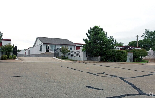
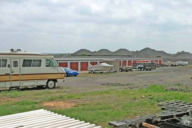
Property Record
2616 S Coltrane Pl, Edmond, OK 73034

Save to a Folder
{{folder.Name}}
{{folder.ListingIds.length}} Properties
{{folder.ListingIds.length}} Property
Create a New Folder
Property Detail
2616 S Coltrane Pl
Oklahoma City, OK
COLTRANE PARK 001 006
127431050
OKLAHOMA
Publicstorage
Oklahoma
B and X Area of moderate flood hazard, usually the area between the limits of the 100-year and 500-year floods.
6
2024
5.55 AC
2025
Edmond
108317
Oklahoma City
67,500 SF
NEARBY LISTINGS FOR SALE OR LEASE
-
-
View all Edmond listings for sale on LoopNet.com
DEMOGRAPHICS near 2616 S Coltrane Pl
1 mile
3 mile
5 mile
2025 Total Population
8,572
53,116
109,333
2030 Population
8,638
53,851
111,045
Pop Growth 2025-2030
+ 0.77%
+ 1.38%
+ 1.57%
Average Age
36
39
39
2025 Total Households
3,644
21,253
42,458
HH Growth 2025-2030
+ 0.96%
+ 1.52%
+ 1.67%
Median Household Inc
$97,946
$92,969
$101,742
Avg Household Size
2.30
2.40
2.50
2025 Avg HH Vehicles
2.00
2.00
2.00
Median Home Value
$389,436
$349,649
$348,038
Median Year Built
1993
1986
1993
Nearby Places
Map Layers
Map Styles
 Street
 Aerial
Layers
 Traffic
 Biking
Places
Listings with unknown addresses are not visible on the map
- Restaurants
- Banks
- Shops
- Fitness
- Groceries
PUBLIC TRANSPORTATION
AIRPORT
Will Rogers World
Drive
Walk
Distance
Will Rogers World
39 min
25.9 mi
Freight Ports
Tulsa Port Of Catoosa
Drive
Walk
Distance
Tulsa Port Of Catoosa
126 min
116.5 mi
Nearby Properties
Address
Land Use
TOTAL SIZE
Lot Size
Zoning
Address
Land Use
TOTAL SIZE
Lot Size
Zoning
200,545 SF
24.93 AC
Address
Land Use
TOTAL SIZE
Lot Size
Zoning
280,581 SF
28.90 AC
Address
Land Use
TOTAL SIZE
Lot Size
Zoning
304,744 SF
21.61 AC
Address
Land Use
TOTAL SIZE
Lot Size
Zoning
371,968 SF
30.50 AC
Address
Land Use
TOTAL SIZE
Lot Size
Zoning
32.33 AC
Address
Land Use
TOTAL SIZE
Lot Size
Zoning
402,880 SF
15.39 AC
Address
Land Use
TOTAL SIZE
Lot Size
Zoning
164,940 SF
27.04 AC
Address
Land Use
TOTAL SIZE
Lot Size
Zoning
242,196 SF
14.07 AC
Address
Land Use
TOTAL SIZE
Lot Size
Zoning
265,194 SF
13.67 AC
Address
Land Use
TOTAL SIZE
Lot Size
Zoning
221,364 SF
12.09 AC
Address
Land Use
TOTAL SIZE
Lot Size
Zoning
147,080 SF
10.38 AC
Address
Land Use
TOTAL SIZE
Lot Size
Zoning
167,664 SF
14.14 AC
Address
Land Use
TOTAL SIZE
Lot Size
Zoning
99,783 SF
16.78 AC
Address
Land Use
TOTAL SIZE
Lot Size
Zoning
8,976 SF
1.14 AC
Address
Land Use
TOTAL SIZE
Lot Size
Zoning
6,636 SF
0.18 AC
Address
Land Use
TOTAL SIZE
Lot Size
Zoning
132,226 SF
11.89 AC
Address
Land Use
TOTAL SIZE
Lot Size
Zoning
64,296 SF
8.43 AC
Address
Land Use
TOTAL SIZE
Lot Size
Zoning
72,273 SF
6.58 AC
Address
Land Use
TOTAL SIZE
Lot Size
Zoning
7,428 SF
1 AC
Address
Land Use
TOTAL SIZE
Lot Size
Zoning
176,307 SF
14.76 AC
Address
Land Use
TOTAL SIZE
Lot Size
Zoning
8,760 SF
1.05 AC
Address
Land Use
TOTAL SIZE
Lot Size
Zoning
197,818 SF
28.97 AC
Address
Land Use
TOTAL SIZE
Lot Size
Zoning
28,150 SF
4.81 AC
Address
Land Use
TOTAL SIZE
Lot Size
Zoning
140,928 SF
9.60 AC
Address
Land Use
TOTAL SIZE
Lot Size
Zoning
159,232 SF
14.06 AC
Address
Land Use
TOTAL SIZE
Lot Size
Zoning
134,995 SF
15.99 AC
Address
Land Use
TOTAL SIZE
Lot Size
Zoning
57,592 SF
8.96 AC
Address
Land Use
TOTAL SIZE
Lot Size
Zoning
66,514 SF
2.67 AC
Address
Land Use
TOTAL SIZE
Lot Size
Zoning
110,250 SF
10 AC
Address
Land Use
TOTAL SIZE
Lot Size
Zoning
1,360 SF
22.18 AC
The World's #1 Commercial Real Estate Marketplace
Connect with us
© 2026 CoStar Group
The information above has been obtained from sources believed reliable. While we do not doubt its accuracy we have not verified it and make no guarantee, warranty or representation about it. It is your responsibility to independently confirm its accuracy and completeness. Any projections, opinions, assumptions, or estimates used are for example only and do not represent the current or future performance of the property. The value of this transaction to you depends on tax and other factors which should be evaluated by your tax, financial, and legal advisors. You and your advisors should conduct a careful, independent investigation of the property to determine to your satisfaction the suitability of the property for your needs.