Property Record
2619 Herr St, Harrisburg, PA 17103
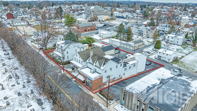

This Property Is For Sale
NEARBY LISTINGS FOR SALE OR LEASE
Property Detail
2619 Herr St
Commercialofficeresidentialmixeduse
Dauphin
X
Pennsylvania
42043C0338D
0.08 AC
2025
Harrisburg Area East
2025
Philadelphia
022200
Harrisburg-Carlisle, PA
2,068 SF
49-003-004
DEMOGRAPHICS near 2619 Herr St
1 Mile
3 Mile
5 Mile
2024 Total Population
13,788
106,495
208,150
2029 Population
14,009
108,837
213,360
Pop Growth 2024-2029
+ 1.60%
+ 2.20%
+ 2.50%
Average Age
39
38
40
2024 Total Households
5,645
44,222
86,643
HH Growth 2024-2029
+ 1.67%
+ 2.27%
+ 2.63%
Median Household Inc
$69,370
$60,436
$71,700
Avg Household Size
2.40
2.30
2.30
2024 Avg HH Vehicles
1.00
1.00
2.00
Median Home Value
$176,376
$189,424
$232,656
Median Year Built
1953
1956
1963
Nearby Places
Map Layers
Map Styles
 Street
 Aerial
- Restaurants
- Banks
- Shops
- Fitness
- Groceries
PUBLIC TRANSPORTATION
COMMUTER RAIL
Harrisburg (Keystone Service - Amtrak, Pennsylvanian - Amtrak)
DRIVE
WALK
Distance
Harrisburg (Keystone Service - Amtrak, Pennsylvanian - Amtrak)
6 min
2.7 mi
AIRPORT
Harrisburg International
DRIVE
WALK
Distance
Harrisburg International
17 min
10.7 mi
Freight Ports
Port of Baltimore
DRIVE
WALK
Distance
Port of Baltimore
113 min
83.0 mi
Nearby Properties
Address
Land Use
TOTAL SIZE
Lot Size
Zoning
Address
Land Use
TOTAL SIZE
Lot Size
Zoning
474,282 SF
4.71 AC
Address
Land Use
TOTAL SIZE
Lot Size
Zoning
615,797 SF
59.70 AC
Address
Land Use
TOTAL SIZE
Lot Size
Zoning
3,025 SF
274.13 AC
Address
Land Use
TOTAL SIZE
Lot Size
Zoning
725,856 SF
2.15 AC
Address
Land Use
TOTAL SIZE
Lot Size
Zoning
210,464 SF
28.80 AC
Address
Land Use
TOTAL SIZE
Lot Size
Zoning
372,234 SF
1.01 AC
Address
Land Use
TOTAL SIZE
Lot Size
Zoning
15,480 SF
17.80 AC
Address
Land Use
TOTAL SIZE
Lot Size
Zoning
482,564 SF
5 AC
Address
Land Use
TOTAL SIZE
Lot Size
Zoning
365,162 SF
19.11 AC
Address
Land Use
TOTAL SIZE
Lot Size
Zoning
577,075 SF
39.55 AC
Address
Land Use
TOTAL SIZE
Lot Size
Zoning
74,032 SF
74.81 AC
Address
Land Use
TOTAL SIZE
Lot Size
Zoning
0.67 AC
Address
Land Use
TOTAL SIZE
Lot Size
Zoning
1,155,340 SF
3.94 AC
Address
Land Use
TOTAL SIZE
Lot Size
Zoning
122,301 SF
32.30 AC
Address
Land Use
TOTAL SIZE
Lot Size
Zoning
349,587 SF
0.53 AC
Address
Land Use
TOTAL SIZE
Lot Size
Zoning
307,080 SF
25 AC
Address
Land Use
TOTAL SIZE
Lot Size
Zoning
329,377 SF
1.66 AC
Address
Land Use
TOTAL SIZE
Lot Size
Zoning
47,022 SF
47.55 AC
Address
Land Use
TOTAL SIZE
Lot Size
Zoning
9,188 SF
46.70 AC
Address
Land Use
TOTAL SIZE
Lot Size
Zoning
2,913 SF
24.28 AC
Address
Land Use
TOTAL SIZE
Lot Size
Zoning
352,350 SF
2.90 AC
Address
Land Use
TOTAL SIZE
Lot Size
Zoning
125,255 SF
26.65 AC
Address
Land Use
TOTAL SIZE
Lot Size
Zoning
215,800 SF
16 AC
Address
Land Use
TOTAL SIZE
Lot Size
Zoning
284,737 SF
28.16 AC
Address
Land Use
TOTAL SIZE
Lot Size
Zoning
5,588 SF
9.29 AC
Address
Land Use
TOTAL SIZE
Lot Size
Zoning
192,390 SF
43.19 AC
Address
Land Use
TOTAL SIZE
Lot Size
Zoning
358,680 SF
3.79 AC
Address
Land Use
TOTAL SIZE
Lot Size
Zoning
186,900 SF
Address
Land Use
TOTAL SIZE
Lot Size
Zoning
167,935 SF
0.57 AC
Address
Land Use
TOTAL SIZE
Lot Size
Zoning
218,468 SF
0.76 AC
The World's #1 Commercial Real Estate Marketplace
Connect with us
© 2026 CoStar Group
The information above has been obtained from sources believed reliable. While we do not doubt its accuracy we have not verified it and make no guarantee, warranty or representation about it. It is your responsibility to independently confirm its accuracy and completeness. Any projections, opinions, assumptions, or estimates used are for example only and do not represent the current or future performance of the property. The value of this transaction to you depends on tax and other factors which should be evaluated by your tax, financial, and legal advisors. You and your advisors should conduct a careful, independent investigation of the property to determine to your satisfaction the suitability of the property for your needs.