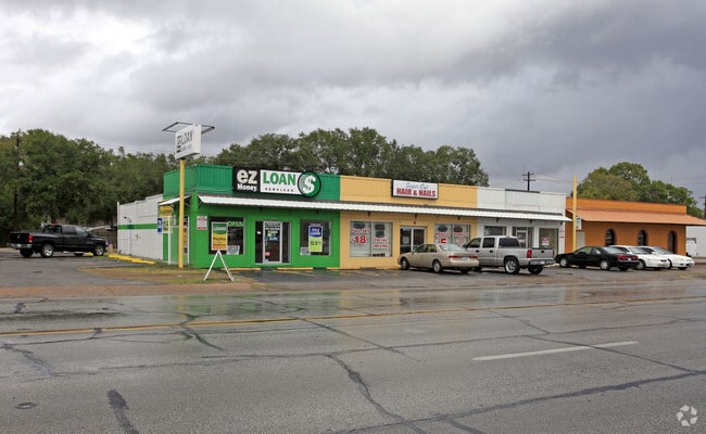
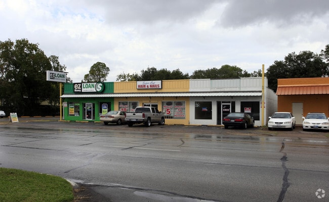
Property Record
2617 Avenue H, Rosenberg, TX 77471

NEARBY LISTINGS FOR SALE OR LEASE
Property Detail
2617 Avenue H
Houston-The Woodlands-Sugar Land, TX
Ward-Waddell Addn
8915-00-009-0120-901
WARD-WADDELL ADDN, BLOCK 9, LOT 12 THRU 14
Commercialnec
Fort Bend
X
Texas
48157C0245L
12-14
2024
0.48 AC
2025
Far Southwest
675000
Houston
4,800 SF
DEMOGRAPHICS near 2617 Avenue H
1 Mile
3 Mile
5 Mile
2024 Total Population
10,862
52,009
101,153
2029 Population
13,013
62,746
122,863
Pop Growth 2024-2029
+ 19.80%
+ 20.64%
+ 21.46%
Average Age
37
37
37
2024 Total Households
3,748
17,735
33,925
HH Growth 2024-2029
+ 20.41%
+ 21.31%
+ 22.28%
Median Household Inc
$41,957
$56,326
$70,459
Avg Household Size
2.80
2.80
2.90
2024 Avg HH Vehicles
2.00
2.00
2.00
Median Home Value
$138,467
$198,780
$255,333
Median Year Built
1977
1989
2008
Nearby Places
Map Layers
Map Styles
 Street
 Aerial
- Restaurants
- Banks
- Shops
- Fitness
- Groceries
PUBLIC TRANSPORTATION
AIRPORT
William P Hobby
DRIVE
WALK
Distance
William P Hobby
57 min
39.8 mi
SALE & LEASE HISTORY
LISTING DATE
SALE/LEASE

Sep 25, 2016
For Lease
Nearby Properties
Address
Land Use
TOTAL SIZE
Lot Size
Zoning
Address
Land Use
TOTAL SIZE
Lot Size
Zoning
44.35 AC
YOSN
Address
Land Use
TOTAL SIZE
Lot Size
Zoning
449,167 SF
73.44 AC
IY
Address
Land Use
TOTAL SIZE
Lot Size
Zoning
504,838 SF
30.59 AC
Address
Land Use
TOTAL SIZE
Lot Size
Zoning
672,112 SF
81.77 AC
YHN
Address
Land Use
TOTAL SIZE
Lot Size
Zoning
283,393 SF
93.42 AC
Address
Land Use
TOTAL SIZE
Lot Size
Zoning
10.84 AC
Address
Land Use
TOTAL SIZE
Lot Size
Zoning
Address
Land Use
TOTAL SIZE
Lot Size
Zoning
438,371 SF
132.75 AC
Address
Land Use
TOTAL SIZE
Lot Size
Zoning
78,077 SF
16.29 AC
Address
Land Use
TOTAL SIZE
Lot Size
Zoning
81,128 SF
8.98 AC
YNQS
Address
Land Use
TOTAL SIZE
Lot Size
Zoning
212,000 SF
0.49 AC
Address
Land Use
TOTAL SIZE
Lot Size
Zoning
169,798 SF
16.29 AC
Address
Land Use
TOTAL SIZE
Lot Size
Zoning
224,099 SF
11.85 AC
Address
Land Use
TOTAL SIZE
Lot Size
Zoning
11.40 AC
Address
Land Use
TOTAL SIZE
Lot Size
Zoning
Address
Land Use
TOTAL SIZE
Lot Size
Zoning
98,691 SF
29.37 AC
Address
Land Use
TOTAL SIZE
Lot Size
Zoning
16.23 AC
Address
Land Use
TOTAL SIZE
Lot Size
Zoning
54,406 SF
13.13 AC
Address
Land Use
TOTAL SIZE
Lot Size
Zoning
3,680 SF
38.68 AC
SMH
Address
Land Use
TOTAL SIZE
Lot Size
Zoning
18.86 AC
Address
Land Use
TOTAL SIZE
Lot Size
Zoning
12.21 AC
Address
Land Use
TOTAL SIZE
Lot Size
Zoning
96,992 SF
14.76 AC
SM
Address
Land Use
TOTAL SIZE
Lot Size
Zoning
28.37 AC
Z
Address
Land Use
TOTAL SIZE
Lot Size
Zoning
64.02 AC
YQ
Address
Land Use
TOTAL SIZE
Lot Size
Zoning
54.25 AC
L
Address
Land Use
TOTAL SIZE
Lot Size
Zoning
94,080 SF
6.23 AC
H
Address
Land Use
TOTAL SIZE
Lot Size
Zoning
132,171 SF
8.86 AC
Address
Land Use
TOTAL SIZE
Lot Size
Zoning
46,959 SF
8.36 AC
S
Address
Land Use
TOTAL SIZE
Lot Size
Zoning
1,216 SF
24.38 AC
YZS
Address
Land Use
TOTAL SIZE
Lot Size
Zoning
The World's #1 Commercial Real Estate Marketplace
Connect with us
© 2025 CoStar Group
The information above has been obtained from sources believed reliable. While we do not doubt its accuracy we have not verified it and make no guarantee, warranty or representation about it. It is your responsibility to independently confirm its accuracy and completeness. Any projections, opinions, assumptions, or estimates used are for example only and do not represent the current or future performance of the property. The value of this transaction to you depends on tax and other factors which should be evaluated by your tax, financial, and legal advisors. You and your advisors should conduct a careful, independent investigation of the property to determine to your satisfaction the suitability of the property for your needs.