Property Record
2617 Moses Grandy Trl, Chesapeake, VA 23323
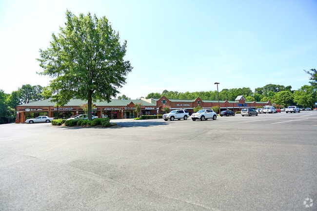

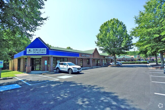
Property Detail
2617 Moses Grandy Trl
0340000002360
PT E AMDED SUB A-1-4 POR E P CHERRY EST PROP 8.6199AC
Stripcommercialcenter
Chesapeake City
B1: NEIGHB
Virginia
B and X Area of moderate flood hazard, usually the area between the limits of the 100-year and 500-year floods.
8.62 AC
2024
Deep Creek
2025
Hampton Roads
021303
Virginia Beach-Chesapeake-Norfolk, VA-NC
66,535 SF
NEARBY LISTINGS FOR SALE OR LEASE
DEMOGRAPHICS near 2617 Moses Grandy Trl
1 mile
3 mile
5 mile
2025 Total Population
8,670
38,490
99,338
2030 Population
8,858
39,211
100,357
Pop Growth 2025-2030
+ 2.17%
+ 1.87%
+ 1.03%
Average Age
36
37
38
2025 Total Households
2,812
12,898
35,471
HH Growth 2025-2030
+ 2.31%
+ 1.93%
+ 1.00%
Median Household Inc
$127,998
$110,665
$87,268
Avg Household Size
3.10
2.90
2.70
2025 Avg HH Vehicles
2.00
2.00
2.00
Median Home Value
$420,896
$398,898
$350,871
Median Year Built
1999
1993
1986
Nearby Places
Map Layers
Map Styles
 Street
 Aerial
Transit
 Traffic
 Biking
Places
Listings with unknown addresses are not visible on the map
- Restaurants
- Banks
- Shops
- Fitness
- Groceries
PUBLIC TRANSPORTATION
AIRPORT
Norfolk International
Drive
Walk
Distance
Norfolk International
26 min
18.8 mi
Newport News/Williamsburg International
Drive
Walk
Distance
Newport News/Williamsburg International
43 min
37.2 mi
Freight Ports
Virginia Port Authority - Portsmouth
Drive
Walk
Distance
Virginia Port Authority - Portsmouth
1 min
8.0 mi
SALE & LEASE HISTORY
LISTING DATE
SALE/LEASE

Sep 25, 2016
For Lease
Jul 27, 2017
For Lease
Nearby Properties
Address
Land Use
TOTAL SIZE
Lot Size
Zoning
Address
Land Use
TOTAL SIZE
Lot Size
Zoning
338,400 SF
96.79 AC
A1: AGRICU
Address
Land Use
TOTAL SIZE
Lot Size
Zoning
26.78 AC
RMF1: MULT
Address
Land Use
TOTAL SIZE
Lot Size
Zoning
178,068 SF
14.72 AC
M1: LIGHT
Address
Land Use
TOTAL SIZE
Lot Size
Zoning
195,637 SF
96.05 AC
RE1: RESID
Address
Land Use
TOTAL SIZE
Lot Size
Zoning
264,975 SF
50.36 AC
R10S: RESI
Address
Land Use
TOTAL SIZE
Lot Size
Zoning
63,050 SF
27.71 AC
O-I: OFFIC
Address
Land Use
TOTAL SIZE
Lot Size
Zoning
107,223 SF
48.07 AC
O-I: OFFIC
Address
Land Use
TOTAL SIZE
Lot Size
Zoning
148,905 SF
7.32 AC
PUD: PLANN
Address
Land Use
TOTAL SIZE
Lot Size
Zoning
213,740 SF
26.51 AC
B2: GENERA
Address
Land Use
TOTAL SIZE
Lot Size
Zoning
130,510 SF
33.74 AC
M1: LIGHT
Address
Land Use
TOTAL SIZE
Lot Size
Zoning
2,434 SF
39.25 AC
B2: GENERA
Address
Land Use
TOTAL SIZE
Lot Size
Zoning
38,354 SF
2.23 AC
PUD: PLANN
Address
Land Use
TOTAL SIZE
Lot Size
Zoning
4,300 SF
11.21 AC
PUD: PLANN
Address
Land Use
TOTAL SIZE
Lot Size
Zoning
126,250 SF
31.69 AC
R10S: RESI
Address
Land Use
TOTAL SIZE
Lot Size
Zoning
167,400 SF
10.74 AC
M1: LIGHT
Address
Land Use
TOTAL SIZE
Lot Size
Zoning
197,533 SF
15 AC
M1: LIGHT
Address
Land Use
TOTAL SIZE
Lot Size
Zoning
59,280 SF
12.23 AC
RMF1: MULT
Address
Land Use
TOTAL SIZE
Lot Size
Zoning
48,360 SF
14.75 AC
M3: WATERF
Address
Land Use
TOTAL SIZE
Lot Size
Zoning
25,610 SF
5.16 AC
B4: SHOPPI
Address
Land Use
TOTAL SIZE
Lot Size
Zoning
20,040 SF
13.34 AC
B2: GENERA
Address
Land Use
TOTAL SIZE
Lot Size
Zoning
65,088 SF
20.50 AC
R10S: RESI
Address
Land Use
TOTAL SIZE
Lot Size
Zoning
41,335 SF
16.35 AC
M1: LIGHT
Address
Land Use
TOTAL SIZE
Lot Size
Zoning
100,792 SF
16.35 AC
R8S: RESID
Address
Land Use
TOTAL SIZE
Lot Size
Zoning
80,496 SF
7.88 AC
RMF1: MULT
Address
Land Use
TOTAL SIZE
Lot Size
Zoning
25,133 SF
34.93 AC
AC: ASSEMB
Address
Land Use
TOTAL SIZE
Lot Size
Zoning
43,800 SF
2.50 AC
PUD: PLANN
Address
Land Use
TOTAL SIZE
Lot Size
Zoning
63,350 SF
9.69 AC
B1: NEIGHB
Address
Land Use
TOTAL SIZE
Lot Size
Zoning
140,699 SF
54.80 AC
M2: GENERA
Address
Land Use
TOTAL SIZE
Lot Size
Zoning
42,174 SF
5.28 AC
PUD: PLANN
Address
Land Use
TOTAL SIZE
Lot Size
Zoning
102,750 SF
4.81 AC
RMF1: MULT
The World's #1 Commercial Real Estate Marketplace
Connect with us
© 2026 CoStar Group
The information above has been obtained from sources believed reliable. While we do not doubt its accuracy we have not verified it and make no guarantee, warranty or representation about it. It is your responsibility to independently confirm its accuracy and completeness. Any projections, opinions, assumptions, or estimates used are for example only and do not represent the current or future performance of the property. The value of this transaction to you depends on tax and other factors which should be evaluated by your tax, financial, and legal advisors. You and your advisors should conduct a careful, independent investigation of the property to determine to your satisfaction the suitability of the property for your needs.