Property Record
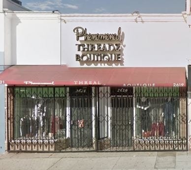
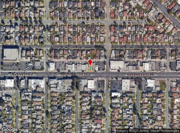
2619 W Manchester Blvd, Inglewood, CA 90305
Current Lease Availabilities
NEARBY LISTINGS FOR SALE OR LEASE
Property Detail
2619 W Manchester Blvd
Los Angeles-Long Beach-Glendale, CA
11156
4010-010-004
TRACT # 11156 LOT 6
Storemultistory
Los Angeles
X
California
06037C1780G
6
2024
0.06 AC
2025
Inglewood/South LA
600801
Los Angeles
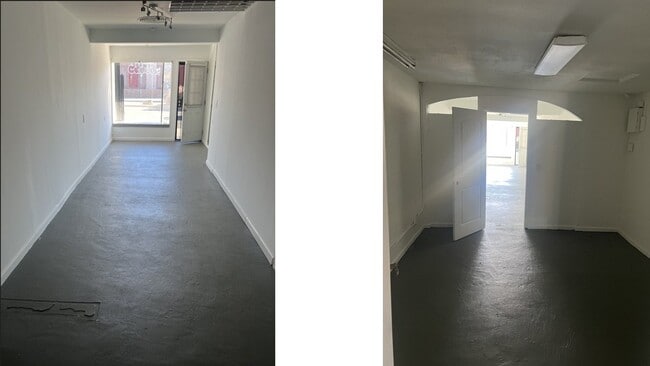
1,369 SF
DEMOGRAPHICS near 2619 W Manchester Blvd
1 Mile
3 Mile
5 Mile
2024 Total Population
26,080
371,671
951,072
2029 Population
25,097
359,365
917,286
Pop Growth 2024-2029
(3.77%)
(3.31%)
(3.55%)
Average Age
44
38
37
2024 Total Households
10,055
116,418
292,036
HH Growth 2024-2029
(4.14%)
(3.51%)
(3.66%)
Median Household Inc
$73,613
$57,064
$60,141
Avg Household Size
2.50
3.10
3.10
2024 Avg HH Vehicles
2.00
2.00
2.00
Median Home Value
$729,263
$684,388
$708,538
Median Year Built
1948
1953
1955
Nearby Places
- Restaurants
- Banks
- Shops
- Fitness
- Groceries
PUBLIC TRANSPORTATION
AIRPORT
Los Angeles International
DRIVE
WALK
Distance
Los Angeles International
11 min
6.0 mi
Long Beach (Daugherty Field)
DRIVE
WALK
Distance
Long Beach (Daugherty Field)
26 min
18.4 mi
Bob Hope
DRIVE
WALK
Distance
Bob Hope
34 min
20.1 mi
Freight Ports
Port of Long Beach
DRIVE
WALK
Distance
Port of Long Beach
29 min
20.2 mi
Nearby Properties
Address
Land Use
TOTAL SIZE
Lot Size
Zoning
Address
Land Use
TOTAL SIZE
Lot Size
Zoning
2,531,696 SF
79.60 AC
INCR*
Address
Land Use
TOTAL SIZE
Lot Size
Zoning
Address
Land Use
TOTAL SIZE
Lot Size
Zoning
Address
Land Use
TOTAL SIZE
Lot Size
Zoning
Address
Land Use
TOTAL SIZE
Lot Size
Zoning
Address
Land Use
TOTAL SIZE
Lot Size
Zoning
724,715 SF
5.76 AC
INCR*
Address
Land Use
TOTAL SIZE
Lot Size
Zoning
227,596 SF
14.38 AC
HAM1YY
Address
Land Use
TOTAL SIZE
Lot Size
Zoning
1,359,630 SF
29 AC
INCR*
Address
Land Use
TOTAL SIZE
Lot Size
Zoning
662,081 SF
2.50 AC
LAC2
Address
Land Use
TOTAL SIZE
Lot Size
Zoning
181,213 SF
3.96 AC
INCR*
Address
Land Use
TOTAL SIZE
Lot Size
Zoning
273,825 SF
7.73 AC
INRM*
Address
Land Use
TOTAL SIZE
Lot Size
Zoning
986,604 SF
42.66 AC
HAM2YY
Address
Land Use
TOTAL SIZE
Lot Size
Zoning
59,422 SF
2.89 AC
HAM2YY
Address
Land Use
TOTAL SIZE
Lot Size
Zoning
144,111 SF
6.94 AC
INM1*
Address
Land Use
TOTAL SIZE
Lot Size
Zoning
196,069 SF
2.72 AC
LAC2
Address
Land Use
TOTAL SIZE
Lot Size
Zoning
544,967 SF
10.74 AC
HAM2YY
Address
Land Use
TOTAL SIZE
Lot Size
Zoning
102,789 SF
0.86 AC
INR3*
Address
Land Use
TOTAL SIZE
Lot Size
Zoning
57,488 SF
4.30 AC
LAPF
Address
Land Use
TOTAL SIZE
Lot Size
Zoning
0.35 AC
INC1*
Address
Land Use
TOTAL SIZE
Lot Size
Zoning
1,106,631 SF
1.12 AC
INC2YY
Address
Land Use
TOTAL SIZE
Lot Size
Zoning
111,254 SF
5.63 AC
INCR
Address
Land Use
TOTAL SIZE
Lot Size
Zoning
233,461 SF
5.48 AC
1NM1*
Address
Land Use
TOTAL SIZE
Lot Size
Zoning
112,875 SF
2.55 AC
INC2VV
Address
Land Use
TOTAL SIZE
Lot Size
Zoning
172,452 SF
3.31 AC
INR4*
Address
Land Use
TOTAL SIZE
Lot Size
Zoning
134,839 SF
1.05 AC
LAC2
Address
Land Use
TOTAL SIZE
Lot Size
Zoning
81,735 SF
4.10 AC
LAR4
Address
Land Use
TOTAL SIZE
Lot Size
Zoning
267,463 SF
INCR
Address
Land Use
TOTAL SIZE
Lot Size
Zoning
130,337 SF
9.31 AC
HAM2
Address
Land Use
TOTAL SIZE
Lot Size
Zoning
203,718 SF
8.74 AC
INM1*
The World's #1 Commercial Real Estate Marketplace
Connect with us
© 2025 CoStar Group
The information above has been obtained from sources believed reliable. While we do not doubt its accuracy we have not verified it and make no guarantee, warranty or representation about it. It is your responsibility to independently confirm its accuracy and completeness. Any projections, opinions, assumptions, or estimates used are for example only and do not represent the current or future performance of the property. The value of this transaction to you depends on tax and other factors which should be evaluated by your tax, financial, and legal advisors. You and your advisors should conduct a careful, independent investigation of the property to determine to your satisfaction the suitability of the property for your needs.