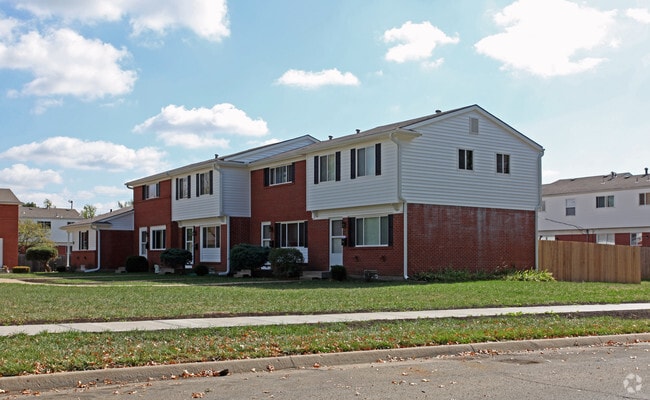
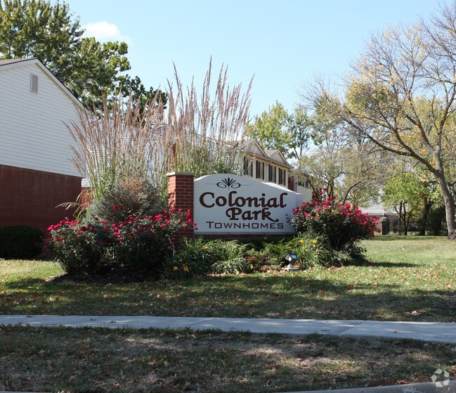
Property Record
2619 Se 25Th St, Topeka, KS 66605
NEARBY LISTINGS FOR SALE OR LEASE
-
-
View all Topeka listings for sale on LoopNet.com
Property Detail
2619 Se 25Th St
132-09-0-30-01-001-000
S09, T12, R16, BEG AT INTER OF S/L COLONIAL DR & W/L GOLDEN AVE, BEING 495(S) S OF 1/4 SEC LN
Apartment
Shawnee
X
Kansas
20177C0219E
14.29 AC
0
East Topeka
2025
Kansas City
003100
Topeka, KS
50,453 SF
DEMOGRAPHICS near 2619 Se 25Th St
1 Mile
3 Mile
5 Mile
2024 Total Population
7,289
52,199
104,471
2029 Population
7,263
52,191
104,055
Pop Growth 2024-2029
(0.36%)
(0.02%)
(0.40%)
Average Age
37
38
39
2024 Total Households
2,761
20,233
43,099
HH Growth 2024-2029
(0.47%)
+ 0.07%
(0.42%)
Median Household Inc
$41,561
$42,350
$47,920
Avg Household Size
2.50
2.40
2.30
2024 Avg HH Vehicles
2.00
2.00
2.00
Median Home Value
$67,505
$93,080
$103,041
Median Year Built
1964
1964
1962
Nearby Places
Map Layers
Map Styles
 Street
 Aerial
- Restaurants
- Banks
- Shops
- Fitness
- Groceries
PUBLIC TRANSPORTATION
COMMUTER RAIL
Topeka Amtrak Station (Southwest Chief - Amtrak)
DRIVE
WALK
Distance
Topeka Amtrak Station (Southwest Chief - Amtrak)
6 min
3.3 mi
Freight Ports
Tulsa Port Of Catoosa
DRIVE
WALK
Distance
Tulsa Port Of Catoosa
278 min
234.5 mi
Nearby Properties
Address
Land Use
TOTAL SIZE
Lot Size
Zoning
Address
Land Use
TOTAL SIZE
Lot Size
Zoning
52,453 SF
17.12 AC
C5,OI2
Address
Land Use
TOTAL SIZE
Lot Size
Zoning
64,058 SF
3.31 AC
C4,OI2
Address
Land Use
TOTAL SIZE
Lot Size
Zoning
336,669 SF
58.82 AC
PUD,C4
Address
Land Use
TOTAL SIZE
Lot Size
Zoning
3.31 AC
OI2
Address
Land Use
TOTAL SIZE
Lot Size
Zoning
77,776 SF
10.64 AC
PUD,M2,R1,
Address
Land Use
TOTAL SIZE
Lot Size
Zoning
285,005 SF
3.10 AC
C4,C5,I1
Address
Land Use
TOTAL SIZE
Lot Size
Zoning
19,120 SF
2.08 AC
R1
Address
Land Use
TOTAL SIZE
Lot Size
Zoning
65,687 SF
7.47 AC
C2,I1,M2
Address
Land Use
TOTAL SIZE
Lot Size
Zoning
137,637 SF
10.43 AC
M2
Address
Land Use
TOTAL SIZE
Lot Size
Zoning
98,898 SF
1.91 AC
C5
Address
Land Use
TOTAL SIZE
Lot Size
Zoning
107,592 SF
14.98 AC
C4,I1,OI2
Address
Land Use
TOTAL SIZE
Lot Size
Zoning
127,947 SF
7.12 AC
C5
Address
Land Use
TOTAL SIZE
Lot Size
Zoning
54,654 SF
0.56 AC
C5
Address
Land Use
TOTAL SIZE
Lot Size
Zoning
112,413 SF
0.73 AC
C5
Address
Land Use
TOTAL SIZE
Lot Size
Zoning
101,766 SF
2.39 AC
C5,I1
Address
Land Use
TOTAL SIZE
Lot Size
Zoning
101,166 SF
3.31 AC
C5
Address
Land Use
TOTAL SIZE
Lot Size
Zoning
165,001 SF
24.83 AC
R1
Address
Land Use
TOTAL SIZE
Lot Size
Zoning
52,261 SF
4.59 AC
OI3
Address
Land Use
TOTAL SIZE
Lot Size
Zoning
161,335 SF
37.32 AC
R1
Address
Land Use
TOTAL SIZE
Lot Size
Zoning
92,118 SF
10.87 AC
R2
Address
Land Use
TOTAL SIZE
Lot Size
Zoning
61,680 SF
2.20 AC
C5
Address
Land Use
TOTAL SIZE
Lot Size
Zoning
188,606 SF
8.42 AC
I1
Address
Land Use
TOTAL SIZE
Lot Size
Zoning
100,954 SF
77.35 AC
R1
Address
Land Use
TOTAL SIZE
Lot Size
Zoning
51,514 SF
1.87 AC
I2
Address
Land Use
TOTAL SIZE
Lot Size
Zoning
15,927 SF
1.44 AC
C4
Address
Land Use
TOTAL SIZE
Lot Size
Zoning
70,058 SF
1.03 AC
C5
Address
Land Use
TOTAL SIZE
Lot Size
Zoning
75,691 SF
5.91 AC
M1,M2
Address
Land Use
TOTAL SIZE
Lot Size
Zoning
25,758 SF
1.64 AC
M2
Address
Land Use
TOTAL SIZE
Lot Size
Zoning
69,020 SF
26.47 AC
RR1
The World's #1 Commercial Real Estate Marketplace
Connect with us
© 2025 CoStar Group
The information above has been obtained from sources believed reliable. While we do not doubt its accuracy we have not verified it and make no guarantee, warranty or representation about it. It is your responsibility to independently confirm its accuracy and completeness. Any projections, opinions, assumptions, or estimates used are for example only and do not represent the current or future performance of the property. The value of this transaction to you depends on tax and other factors which should be evaluated by your tax, financial, and legal advisors. You and your advisors should conduct a careful, independent investigation of the property to determine to your satisfaction the suitability of the property for your needs.