Property Record
262 Posada Ln, Templeton, CA 93465
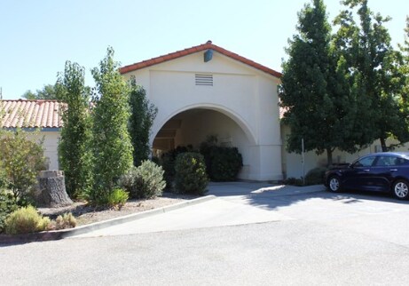
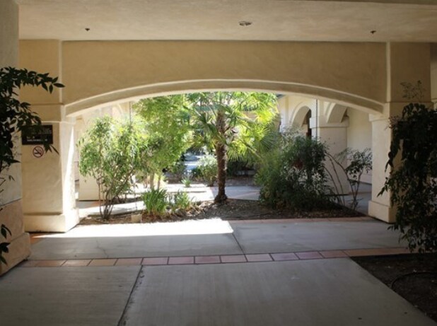

Property Detail
262 Posada Ln
040-360-039
PM 54-72 UNIT B & PTN PAR 1
Medicalbuilding
SAN LUIS OBISPO
OP
California
B and X Area of moderate flood hazard, usually the area between the limits of the 100-year and 500-year floods.
0.12 AC
2024
North 101 Corridor
2025
San Luis Obispo/Paso Robles
012707
San Luis Obispo-Paso Robles, CA
NEARBY LISTINGS FOR SALE OR LEASE
DEMOGRAPHICS near 262 Posada Ln
1 mile
3 mile
5 mile
2025 Total Population
4,900
10,309
26,616
2030 Population
4,844
10,154
26,246
Pop Growth 2025-2030
(1.14%)
(1.50%)
(1.39%)
Average Age
41
43
42
2025 Total Households
1,733
3,847
10,028
HH Growth 2025-2030
(1.44%)
(1.82%)
(1.67%)
Median Household Inc
$117,465
$109,909
$105,183
Avg Household Size
2.60
2.60
2.60
2025 Avg HH Vehicles
2.00
2.00
2.00
Median Home Value
$792,912
$790,797
$796,368
Median Year Built
1992
1992
1987
Nearby Places
Map Layers
Map Styles
 Street
 Aerial
Transit
 Traffic
 Biking
Places
Listings with unknown addresses are not visible on the map
- Restaurants
- Banks
- Shops
- Fitness
- Groceries
PUBLIC TRANSPORTATION
COMMUTER RAIL
Drive
Walk
Distance
10 min
5.8 mi
AIRPORT
San Luis County Regional
Drive
Walk
Distance
San Luis County Regional
40 min
29.2 mi
Nearby Properties
Address
Land Use
TOTAL SIZE
Lot Size
Zoning
Address
Land Use
TOTAL SIZE
Lot Size
Zoning
16 AC
PF
Address
Land Use
TOTAL SIZE
Lot Size
Zoning
138.68 AC
AG
Address
Land Use
TOTAL SIZE
Lot Size
Zoning
88,191 SF
4.01 AC
CPK
Address
Land Use
TOTAL SIZE
Lot Size
Zoning
1.78 AC
CPK
Address
Land Use
TOTAL SIZE
Lot Size
Zoning
25,298 SF
1.84 AC
RSF
Address
Land Use
TOTAL SIZE
Lot Size
Zoning
49,520 SF
1.57 AC
C2
Address
Land Use
TOTAL SIZE
Lot Size
Zoning
3.26 AC
OP
Address
Land Use
TOTAL SIZE
Lot Size
Zoning
46,269 SF
2.30 AC
C2
Address
Land Use
TOTAL SIZE
Lot Size
Zoning
26,256 SF
1.19 AC
OP
Address
Land Use
TOTAL SIZE
Lot Size
Zoning
64,748 SF
5.41 AC
RMF
Address
Land Use
TOTAL SIZE
Lot Size
Zoning
12 AC
CPK
Address
Land Use
TOTAL SIZE
Lot Size
Zoning
26,866 SF
2.01 AC
OP
Address
Land Use
TOTAL SIZE
Lot Size
Zoning
46,942 SF
2.82 AC
IND
Address
Land Use
TOTAL SIZE
Lot Size
Zoning
8.75 AC
Address
Land Use
TOTAL SIZE
Lot Size
Zoning
4.45 AC
OP
Address
Land Use
TOTAL SIZE
Lot Size
Zoning
228.80 AC
AG
Address
Land Use
TOTAL SIZE
Lot Size
Zoning
2,080 SF
2.76 AC
OP
Address
Land Use
TOTAL SIZE
Lot Size
Zoning
21,230 SF
2.36 AC
CR
Address
Land Use
TOTAL SIZE
Lot Size
Zoning
41,800 SF
3 AC
IND
Address
Land Use
TOTAL SIZE
Lot Size
Zoning
18,765 SF
1.30 AC
OP
Address
Land Use
TOTAL SIZE
Lot Size
Zoning
5.40 AC
RMF
Address
Land Use
TOTAL SIZE
Lot Size
Zoning
11,317 SF
1.62 AC
CR
Address
Land Use
TOTAL SIZE
Lot Size
Zoning
3.94 AC
CR
Address
Land Use
TOTAL SIZE
Lot Size
Zoning
151.15 AC
AG
Address
Land Use
TOTAL SIZE
Lot Size
Zoning
1,951 SF
51.57 AC
AG
Address
Land Use
TOTAL SIZE
Lot Size
Zoning
1,168 SF
4.82 AC
IND
Address
Land Use
TOTAL SIZE
Lot Size
Zoning
9,700 SF
0.87 AC
OP
Address
Land Use
TOTAL SIZE
Lot Size
Zoning
1.20 AC
CR
Address
Land Use
TOTAL SIZE
Lot Size
Zoning
10,102 SF
3.80 AC
Address
Land Use
TOTAL SIZE
Lot Size
Zoning
9,869 SF
2.11 AC
C2
The World's #1 Commercial Real Estate Marketplace
Connect with us
© 2026 CoStar Group
The information above has been obtained from sources believed reliable. While we do not doubt its accuracy we have not verified it and make no guarantee, warranty or representation about it. It is your responsibility to independently confirm its accuracy and completeness. Any projections, opinions, assumptions, or estimates used are for example only and do not represent the current or future performance of the property. The value of this transaction to you depends on tax and other factors which should be evaluated by your tax, financial, and legal advisors. You and your advisors should conduct a careful, independent investigation of the property to determine to your satisfaction the suitability of the property for your needs.