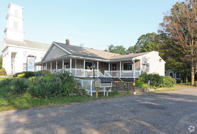
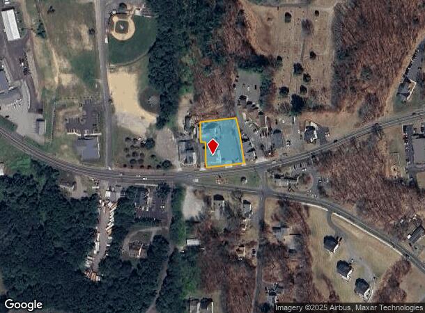
Property Record
262 Spielman Hwy, Burlington, CT 06013

NEARBY LISTINGS FOR SALE OR LEASE
-
-
View all Burlington listings for lease on LoopNet.com
Property Detail
262 Spielman Hwy
BURL-001204-000000-000005
Hartford
Commercialnec
Connecticut
X
5
09003C0315F
0.70 AC
2025
Southwest Outlying
2025
Hartford
410102
Hartford-West Hartford-East Hartford, CT
DEMOGRAPHICS near 262 Spielman Hwy
1 Mile
3 Mile
5 Mile
2024 Total Population
1,018
7,621
42,065
2029 Population
1,026
7,610
41,878
Pop Growth 2024-2029
+ 0.79%
(0.14%)
(0.44%)
Average Age
43
42
43
2024 Total Households
375
2,749
16,205
HH Growth 2024-2029
+ 0.80%
(0.11%)
(0.49%)
Median Household Inc
$148,310
$153,166
$125,873
Avg Household Size
2.70
2.70
2.60
2024 Avg HH Vehicles
2.00
2.00
2.00
Median Home Value
$357,586
$382,644
$355,569
Median Year Built
1982
1984
1977
Nearby Places
Map Layers
Map Styles
 Street
 Aerial
- Restaurants
- Banks
- Shops
- Fitness
- Groceries
PUBLIC TRANSPORTATION
AIRPORT
Bradley International
DRIVE
WALK
Distance
Bradley International
53 min
26.9 mi
Tweed/New Haven
DRIVE
WALK
Distance
Tweed/New Haven
65 min
44.9 mi
Freight Ports
Port of New Haven
DRIVE
WALK
Distance
Port of New Haven
61 min
42.5 mi
SALE & LEASE HISTORY
LISTING DATE
SALE/LEASE

May 26, 2017
For Lease
Dec 27, 2017
For Lease
Nearby Properties
Address
Land Use
TOTAL SIZE
Lot Size
Zoning
Address
Land Use
TOTAL SIZE
Lot Size
Zoning
52.40 AC
R44
Address
Land Use
TOTAL SIZE
Lot Size
Zoning
4.98 AC
R44
Address
Land Use
TOTAL SIZE
Lot Size
Zoning
1,079.49 AC
PS/UD
Address
Land Use
TOTAL SIZE
Lot Size
Zoning
452.94 AC
R44
Address
Land Use
TOTAL SIZE
Lot Size
Zoning
36.93 AC
ROS
Address
Land Use
TOTAL SIZE
Lot Size
Zoning
5.50 AC
CB
Address
Land Use
TOTAL SIZE
Lot Size
Zoning
5.39 AC
CB
Address
Land Use
TOTAL SIZE
Lot Size
Zoning
508 AC
R44
Address
Land Use
TOTAL SIZE
Lot Size
Zoning
34.98 AC
R40
Address
Land Use
TOTAL SIZE
Lot Size
Zoning
448.95 AC
R44
Address
Land Use
TOTAL SIZE
Lot Size
Zoning
446.60 AC
R44
Address
Land Use
TOTAL SIZE
Lot Size
Zoning
2.83 AC
CB
Address
Land Use
TOTAL SIZE
Lot Size
Zoning
15,558 SF
11.14 AC
R44
Address
Land Use
TOTAL SIZE
Lot Size
Zoning
12.85 AC
CB
Address
Land Use
TOTAL SIZE
Lot Size
Zoning
335 AC
R44
Address
Land Use
TOTAL SIZE
Lot Size
Zoning
13,214 SF
2.05 AC
CB
Address
Land Use
TOTAL SIZE
Lot Size
Zoning
267 AC
R44
Address
Land Use
TOTAL SIZE
Lot Size
Zoning
2,578 SF
245 AC
R44
Address
Land Use
TOTAL SIZE
Lot Size
Zoning
8,592 SF
1.16 AC
CB
Address
Land Use
TOTAL SIZE
Lot Size
Zoning
9,880 SF
1.88 AC
CB
Address
Land Use
TOTAL SIZE
Lot Size
Zoning
8.85 AC
I-2
Address
Land Use
TOTAL SIZE
Lot Size
Zoning
251 AC
R44
Address
Land Use
TOTAL SIZE
Lot Size
Zoning
311.30 AC
R44
Address
Land Use
TOTAL SIZE
Lot Size
Zoning
12 AC
R44
Address
Land Use
TOTAL SIZE
Lot Size
Zoning
19,836 SF
4.60 AC
Address
Land Use
TOTAL SIZE
Lot Size
Zoning
23,875 SF
6.24 AC
I-1
Address
Land Use
TOTAL SIZE
Lot Size
Zoning
225 AC
R44
Address
Land Use
TOTAL SIZE
Lot Size
Zoning
Address
Land Use
TOTAL SIZE
Lot Size
Zoning
6,050 SF
274 AC
R44
Address
Land Use
TOTAL SIZE
Lot Size
Zoning
190 AC
R44
The World's #1 Commercial Real Estate Marketplace
Connect with us
© 2025 CoStar Group
The information above has been obtained from sources believed reliable. While we do not doubt its accuracy we have not verified it and make no guarantee, warranty or representation about it. It is your responsibility to independently confirm its accuracy and completeness. Any projections, opinions, assumptions, or estimates used are for example only and do not represent the current or future performance of the property. The value of this transaction to you depends on tax and other factors which should be evaluated by your tax, financial, and legal advisors. You and your advisors should conduct a careful, independent investigation of the property to determine to your satisfaction the suitability of the property for your needs.