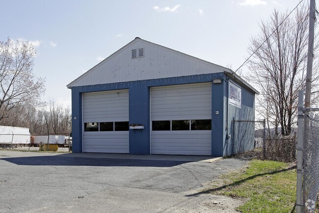
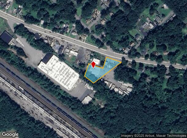
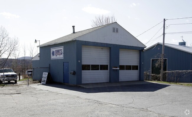
Property Record
262 Summer St, Lunenburg, MA 01462
NEARBY LISTINGS FOR SALE OR LEASE
Property Detail
262 Summer St
Commercialnec
Worcester
X
Massachusetts
25027C0259F
0.77 AC
2025
Fitchburg/Leominster
2025
Boston
712101
Worcester, MA-CT
896 SF
LUNE-001170-000026
DEMOGRAPHICS near 262 Summer St
1 Mile
3 Mile
5 Mile
2024 Total Population
8,599
58,160
96,313
2029 Population
8,641
57,935
95,946
Pop Growth 2024-2029
+ 0.49%
(0.39%)
(0.38%)
Average Age
41
40
40
2024 Total Households
3,677
23,182
38,075
HH Growth 2024-2029
+ 0.49%
(0.40%)
(0.41%)
Median Household Inc
$61,208
$66,849
$72,241
Avg Household Size
2.30
2.40
2.40
2024 Avg HH Vehicles
2.00
2.00
2.00
Median Home Value
$325,897
$316,236
$320,972
Median Year Built
1973
1956
1959
Nearby Places
Map Layers
Map Styles
 Street
 Aerial
- Restaurants
- Banks
- Shops
- Fitness
- Groceries
PUBLIC TRANSPORTATION
COMMUTER RAIL
Fitchburg (Fitchburg/South Acton Line - Massachusetts Bay Transportation Authority Commuter Rail (Purple Line))
DRIVE
WALK
Distance
Fitchburg (Fitchburg/South Acton Line - Massachusetts Bay Transportation Authority Commuter Rail (Purple Line))
7 min
2.4 mi
North Leominster (Fitchburg/South Acton Line - Massachusetts Bay Transportation Authority Commuter Rail (Purple Line))
DRIVE
WALK
Distance
North Leominster (Fitchburg/South Acton Line - Massachusetts Bay Transportation Authority Commuter Rail (Purple Line))
7 min
3.0 mi
AIRPORT
Worcester Regional
DRIVE
WALK
Distance
Worcester Regional
46 min
29.9 mi
Freight Ports
Port of Boston
DRIVE
WALK
Distance
Port of Boston
75 min
47.5 mi
Nearby Properties
Address
Land Use
TOTAL SIZE
Lot Size
Zoning
Address
Land Use
TOTAL SIZE
Lot Size
Zoning
39.94 AC
Address
Land Use
TOTAL SIZE
Lot Size
Zoning
20.19 AC
Address
Land Use
TOTAL SIZE
Lot Size
Zoning
11.88 AC
FSU
Address
Land Use
TOTAL SIZE
Lot Size
Zoning
65.15 AC
Address
Land Use
TOTAL SIZE
Lot Size
Zoning
144,800 SF
1.58 AC
RC
Address
Land Use
TOTAL SIZE
Lot Size
Zoning
20,188 SF
18.86 AC
Address
Land Use
TOTAL SIZE
Lot Size
Zoning
119,783 SF
2.80 AC
FSC
Address
Land Use
TOTAL SIZE
Lot Size
Zoning
12.11 AC
RA
Address
Land Use
TOTAL SIZE
Lot Size
Zoning
41,182 SF
339 AC
AI
Address
Land Use
TOTAL SIZE
Lot Size
Zoning
35.43 AC
RA
Address
Land Use
TOTAL SIZE
Lot Size
Zoning
91,082 SF
4.09 AC
FSC
Address
Land Use
TOTAL SIZE
Lot Size
Zoning
176,003 SF
12.46 AC
RA
Address
Land Use
TOTAL SIZE
Lot Size
Zoning
3.13 AC
DB
Address
Land Use
TOTAL SIZE
Lot Size
Zoning
114,360 SF
6.10 AC
RA
Address
Land Use
TOTAL SIZE
Lot Size
Zoning
76,396 SF
1.99 AC
DB
Address
Land Use
TOTAL SIZE
Lot Size
Zoning
19.83 AC
RB
Address
Land Use
TOTAL SIZE
Lot Size
Zoning
30,078 SF
19.66 AC
Address
Land Use
TOTAL SIZE
Lot Size
Zoning
47,173 SF
0.76 AC
Address
Land Use
TOTAL SIZE
Lot Size
Zoning
77,758 SF
7.78 AC
Address
Land Use
TOTAL SIZE
Lot Size
Zoning
16.04 AC
RA
Address
Land Use
TOTAL SIZE
Lot Size
Zoning
220,142 SF
28 AC
RA
Address
Land Use
TOTAL SIZE
Lot Size
Zoning
51,492 SF
9.34 AC
Address
Land Use
TOTAL SIZE
Lot Size
Zoning
Address
Land Use
TOTAL SIZE
Lot Size
Zoning
56.75 AC
Address
Land Use
TOTAL SIZE
Lot Size
Zoning
11.14 AC
Address
Land Use
TOTAL SIZE
Lot Size
Zoning
66.70 AC
Address
Land Use
TOTAL SIZE
Lot Size
Zoning
135,070 SF
6 AC
Address
Land Use
TOTAL SIZE
Lot Size
Zoning
74,060 SF
7.98 AC
Address
Land Use
TOTAL SIZE
Lot Size
Zoning
118,587 SF
22.30 AC
Address
Land Use
TOTAL SIZE
Lot Size
Zoning
33,000 SF
0.33 AC
DB
The World's #1 Commercial Real Estate Marketplace
Connect with us
© 2025 CoStar Group
The information above has been obtained from sources believed reliable. While we do not doubt its accuracy we have not verified it and make no guarantee, warranty or representation about it. It is your responsibility to independently confirm its accuracy and completeness. Any projections, opinions, assumptions, or estimates used are for example only and do not represent the current or future performance of the property. The value of this transaction to you depends on tax and other factors which should be evaluated by your tax, financial, and legal advisors. You and your advisors should conduct a careful, independent investigation of the property to determine to your satisfaction the suitability of the property for your needs.