Property Record
2620 Delafield St, Houston, TX 77023
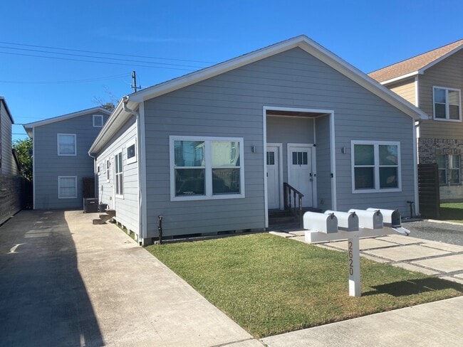
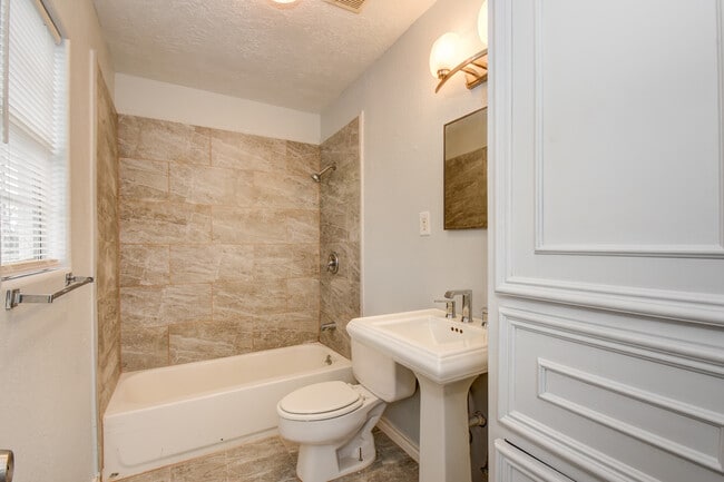
This Property Is For Sale
NEARBY LISTINGS FOR SALE OR LEASE
Property Detail
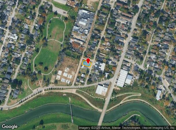
2620 Delafield St
Houston-The Woodlands-Sugar Land, TX
W L Edmundson Sec 7
0563490000120
Harris
Duplex
Texas
X
0.12 AC
48201C0880M
Gulfgate-Pine Valley
2,486 SF
Houston
DEMOGRAPHICS near 2620 Delafield St
1 Mile
3 Mile
5 Mile
2024 Total Population
11,338
159,389
401,238
2029 Population
11,478
164,605
415,236
Pop Growth 2024-2029
+ 1.23%
+ 3.27%
+ 3.49%
Average Age
37
37
37
2024 Total Households
3,908
55,729
156,003
HH Growth 2024-2029
+ 1.13%
+ 3.52%
+ 3.84%
Median Household Inc
$42,979
$39,906
$49,464
Avg Household Size
2.80
2.60
2.30
2024 Avg HH Vehicles
2.00
2.00
1.00
Median Home Value
$170,634
$181,337
$195,175
Median Year Built
1955
1958
1972
Nearby Places
Map Layers
Map Styles
 Street
 Aerial
- Restaurants
- Banks
- Shops
- Fitness
- Groceries
PUBLIC TRANSPORTATION
COMMUTER RAIL
DRIVE
WALK
Distance
10 min
5.8 mi
AIRPORT
William P Hobby
DRIVE
WALK
Distance
William P Hobby
18 min
8.2 mi
George Bush Intcntl/Houston
DRIVE
WALK
Distance
George Bush Intcntl/Houston
33 min
25.5 mi
Nearby Properties
Address
Land Use
TOTAL SIZE
Lot Size
Zoning
Address
Land Use
TOTAL SIZE
Lot Size
Zoning
453,987 SF
4.33 AC
Address
Land Use
TOTAL SIZE
Lot Size
Zoning
403,242 SF
46.18 AC
Address
Land Use
TOTAL SIZE
Lot Size
Zoning
1,171,276 SF
44.19 AC
Address
Land Use
TOTAL SIZE
Lot Size
Zoning
278,362 SF
1.70 AC
Address
Land Use
TOTAL SIZE
Lot Size
Zoning
159,235 SF
1.49 AC
Address
Land Use
TOTAL SIZE
Lot Size
Zoning
242,936 SF
Address
Land Use
TOTAL SIZE
Lot Size
Zoning
329,500 SF
1.82 AC
Address
Land Use
TOTAL SIZE
Lot Size
Zoning
310,171 SF
2.35 AC
Address
Land Use
TOTAL SIZE
Lot Size
Zoning
17.84 AC
Address
Land Use
TOTAL SIZE
Lot Size
Zoning
245,307 SF
1.67 AC
Address
Land Use
TOTAL SIZE
Lot Size
Zoning
198,023 SF
17.87 AC
Address
Land Use
TOTAL SIZE
Lot Size
Zoning
901,984 SF
59.37 AC
Address
Land Use
TOTAL SIZE
Lot Size
Zoning
504,018 SF
37.16 AC
Address
Land Use
TOTAL SIZE
Lot Size
Zoning
419,760 SF
15.27 AC
Address
Land Use
TOTAL SIZE
Lot Size
Zoning
156,349 SF
1.44 AC
Address
Land Use
TOTAL SIZE
Lot Size
Zoning
923,370 SF
13.72 AC
Address
Land Use
TOTAL SIZE
Lot Size
Zoning
785,097 SF
27.77 AC
Address
Land Use
TOTAL SIZE
Lot Size
Zoning
985,528 SF
22.64 AC
Address
Land Use
TOTAL SIZE
Lot Size
Zoning
923,370 SF
13.76 AC
Address
Land Use
TOTAL SIZE
Lot Size
Zoning
232,915 SF
7.89 AC
Address
Land Use
TOTAL SIZE
Lot Size
Zoning
228,886 SF
1.85 AC
Address
Land Use
TOTAL SIZE
Lot Size
Zoning
267,844 SF
10.98 AC
Address
Land Use
TOTAL SIZE
Lot Size
Zoning
194,296 SF
15.13 AC
Address
Land Use
TOTAL SIZE
Lot Size
Zoning
153,240 SF
5.98 AC
Address
Land Use
TOTAL SIZE
Lot Size
Zoning
210,476 SF
9.60 AC
Address
Land Use
TOTAL SIZE
Lot Size
Zoning
143,440 SF
1.06 AC
Address
Land Use
TOTAL SIZE
Lot Size
Zoning
215,960 SF
0.98 AC
Address
Land Use
TOTAL SIZE
Lot Size
Zoning
595,069 SF
17.77 AC
Address
Land Use
TOTAL SIZE
Lot Size
Zoning
78,073 SF
5.45 AC
Address
Land Use
TOTAL SIZE
Lot Size
Zoning
100,458 SF
8.54 AC
The World's #1 Commercial Real Estate Marketplace
Connect with us
© 2025 CoStar Group
The information above has been obtained from sources believed reliable. While we do not doubt its accuracy we have not verified it and make no guarantee, warranty or representation about it. It is your responsibility to independently confirm its accuracy and completeness. Any projections, opinions, assumptions, or estimates used are for example only and do not represent the current or future performance of the property. The value of this transaction to you depends on tax and other factors which should be evaluated by your tax, financial, and legal advisors. You and your advisors should conduct a careful, independent investigation of the property to determine to your satisfaction the suitability of the property for your needs.