Property Record
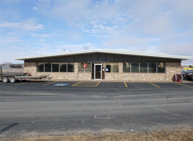
2620 Highway 30 E, Kearney, NE 68847

NEARBY LISTINGS FOR SALE OR LEASE
Property Detail
2620 Highway 30 E
Kearney, NE
Rovar Park Third
605152627
ROVAR PARK THIRD LT 8 BLK 1
Realpropertynec
Buffalo
X
Nebraska
31019C0610D
8
2024
1.59 AC
2025
I-80 Corridor
969300
Other Market Areas
6,860 SF
DEMOGRAPHICS near 2620 Highway 30 E
1 Mile
3 Mile
5 Mile
2024 Total Population
2,817
28,284
37,986
2029 Population
2,906
29,430
39,558
Pop Growth 2024-2029
+ 3.16%
+ 4.05%
+ 4.14%
Average Age
36
37
37
2024 Total Households
1,175
11,155
15,113
HH Growth 2024-2029
+ 3.23%
+ 4.15%
+ 4.24%
Median Household Inc
$47,554
$64,451
$66,203
Avg Household Size
2.40
2.30
2.30
2024 Avg HH Vehicles
2.00
2.00
2.00
Median Home Value
$109,722
$197,194
$220,588
Median Year Built
1979
1978
1982
Nearby Places
Map Layers
Map Styles
 Street
 Aerial
- Restaurants
- Banks
- Shops
- Fitness
- Groceries
SALE & LEASE HISTORY
LISTING DATE
SALE/LEASE

Feb 03, 2021
For Sale
Nearby Properties
Address
Land Use
TOTAL SIZE
Lot Size
Zoning
Address
Land Use
TOTAL SIZE
Lot Size
Zoning
105,277 SF
20.70 AC
COMMERCIAL
Address
Land Use
TOTAL SIZE
Lot Size
Zoning
95,530 SF
3.27 AC
COMMERCIAL
Address
Land Use
TOTAL SIZE
Lot Size
Zoning
412,500 SF
61.21 AC
INDUSTRIAL
Address
Land Use
TOTAL SIZE
Lot Size
Zoning
333,726 SF
22.20 AC
COMMERCIAL
Address
Land Use
TOTAL SIZE
Lot Size
Zoning
55,080 SF
44.96 AC
INDUSTRIAL
Address
Land Use
TOTAL SIZE
Lot Size
Zoning
37,515 SF
COMMERCIAL
Address
Land Use
TOTAL SIZE
Lot Size
Zoning
855 SF
19.51 AC
COMMERCIAL
Address
Land Use
TOTAL SIZE
Lot Size
Zoning
60,000 SF
19.93 AC
INDUSTRIAL
Address
Land Use
TOTAL SIZE
Lot Size
Zoning
21,600 SF
15.58 AC
COMMERCIAL
Address
Land Use
TOTAL SIZE
Lot Size
Zoning
13,476 SF
7.44 AC
COMMERCIAL
Address
Land Use
TOTAL SIZE
Lot Size
Zoning
22,204 SF
12.40 AC
COMMERCIAL
Address
Land Use
TOTAL SIZE
Lot Size
Zoning
101,588 SF
10.51 AC
COMMERCIAL
Address
Land Use
TOTAL SIZE
Lot Size
Zoning
68,992 SF
14.05 AC
COMMERCIAL
Address
Land Use
TOTAL SIZE
Lot Size
Zoning
34,280 SF
2.76 AC
COMMERCIAL
Address
Land Use
TOTAL SIZE
Lot Size
Zoning
1,752 SF
6.90 AC
MULTI-FAMI
Address
Land Use
TOTAL SIZE
Lot Size
Zoning
13,736 SF
6.88 AC
MULTI-FAMI
Address
Land Use
TOTAL SIZE
Lot Size
Zoning
4,374 SF
12.46 AC
COMMERCIAL
Address
Land Use
TOTAL SIZE
Lot Size
Zoning
4,800 SF
12.10 AC
COMMERCIAL
Address
Land Use
TOTAL SIZE
Lot Size
Zoning
5,000 SF
53.38 AC
INDUSTRIAL
Address
Land Use
TOTAL SIZE
Lot Size
Zoning
2,880 SF
8.36 AC
COMMERCIAL
Address
Land Use
TOTAL SIZE
Lot Size
Zoning
42,480 SF
1.34 AC
OTHER
Address
Land Use
TOTAL SIZE
Lot Size
Zoning
33,192 SF
3.91 AC
COMMERCIAL
Address
Land Use
TOTAL SIZE
Lot Size
Zoning
110,442 SF
7.88 AC
COMMERCIAL
Address
Land Use
TOTAL SIZE
Lot Size
Zoning
170,410 SF
19.42 AC
INDUSTRIAL
Address
Land Use
TOTAL SIZE
Lot Size
Zoning
336 SF
60.40 AC
COMMERCIAL
Address
Land Use
TOTAL SIZE
Lot Size
Zoning
5,130 SF
5.61 AC
MULTI-FAMI
Address
Land Use
TOTAL SIZE
Lot Size
Zoning
6,517 SF
1.88 AC
COMMERCIAL
Address
Land Use
TOTAL SIZE
Lot Size
Zoning
25,300 SF
7.70 AC
COMMERCIAL
Address
Land Use
TOTAL SIZE
Lot Size
Zoning
58,069 SF
5.44 AC
COMMERCIAL
Address
Land Use
TOTAL SIZE
Lot Size
Zoning
71,835 SF
37.66 AC
COMMERCIAL
The World's #1 Commercial Real Estate Marketplace
Connect with us
© 2026 CoStar Group
The information above has been obtained from sources believed reliable. While we do not doubt its accuracy we have not verified it and make no guarantee, warranty or representation about it. It is your responsibility to independently confirm its accuracy and completeness. Any projections, opinions, assumptions, or estimates used are for example only and do not represent the current or future performance of the property. The value of this transaction to you depends on tax and other factors which should be evaluated by your tax, financial, and legal advisors. You and your advisors should conduct a careful, independent investigation of the property to determine to your satisfaction the suitability of the property for your needs.