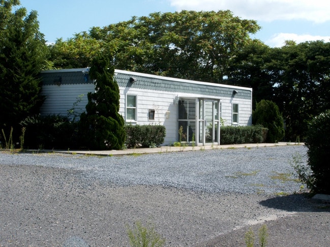
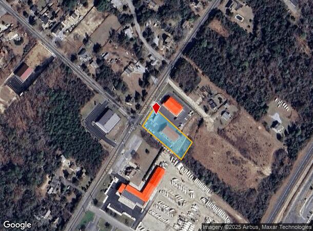
Property Record
2620 N Route 9, Ocean View, NJ 08230
NEARBY LISTINGS FOR SALE OR LEASE
-
-
View all Ocean View listings for sale on LoopNet.com
Property Detail
2620 N Route 9
04 00241-0000-00006- 01
Cape May
Vacantlandnec
New Jersey
X
6.1
34009C0161F
1 AC
2024
South Shore/Vineland
2025
Other Market Areas
020700
Ocean City, NJ
DEMOGRAPHICS near 2620 N Route 9
1 Mile
3 Mile
5 Mile
2024 Total Population
369
6,070
12,056
2029 Population
312
5,938
11,727
Pop Growth 2024-2029
(15.45%)
(2.17%)
(2.73%)
Average Age
45
48
49
2024 Total Households
126
2,516
5,054
HH Growth 2024-2029
(19.05%)
(1.47%)
(2.00%)
Median Household Inc
$106,250
$101,391
$93,825
Avg Household Size
2.40
2.30
2.20
2024 Avg HH Vehicles
2.00
2.00
2.00
Median Home Value
$274,999
$431,361
$439,949
Median Year Built
1989
1988
1988
Nearby Places
Map Layers
Map Styles
 Street
 Aerial
- Restaurants
- Banks
- Shops
- Fitness
- Groceries
PUBLIC TRANSPORTATION
AIRPORT
Atlantic City International
DRIVE
WALK
Distance
Atlantic City International
54 min
27.9 mi
Freight Ports
Broadway Terminal - Pier 5
DRIVE
WALK
Distance
Broadway Terminal - Pier 5
85 min
69.8 mi
SALE & LEASE HISTORY
LISTING DATE
SALE/LEASE

Mar 24, 2017
For Sale
Nearby Properties
Address
Land Use
TOTAL SIZE
Lot Size
Zoning
Address
Land Use
TOTAL SIZE
Lot Size
Zoning
5,692 SF
20.40 AC
OVCC
Address
Land Use
TOTAL SIZE
Lot Size
Zoning
Address
Land Use
TOTAL SIZE
Lot Size
Zoning
23.58 AC
R3
Address
Land Use
TOTAL SIZE
Lot Size
Zoning
6,743 SF
1.14 AC
Z
Address
Land Use
TOTAL SIZE
Lot Size
Zoning
104.80 AC
R3
Address
Land Use
TOTAL SIZE
Lot Size
Zoning
8.66 AC
TCC
Address
Land Use
TOTAL SIZE
Lot Size
Zoning
2.30 AC
Address
Land Use
TOTAL SIZE
Lot Size
Zoning
Address
Land Use
TOTAL SIZE
Lot Size
Zoning
1,832 SF
20.10 AC
TCR
Address
Land Use
TOTAL SIZE
Lot Size
Zoning
1.26 AC
Address
Land Use
TOTAL SIZE
Lot Size
Zoning
31.86 AC
R3
Address
Land Use
TOTAL SIZE
Lot Size
Zoning
25.22 AC
OVCR
Address
Land Use
TOTAL SIZE
Lot Size
Zoning
2,228 SF
35.44 AC
R3
Address
Land Use
TOTAL SIZE
Lot Size
Zoning
Address
Land Use
TOTAL SIZE
Lot Size
Zoning
41.66 AC
R3
Address
Land Use
TOTAL SIZE
Lot Size
Zoning
2,280 SF
42.59 AC
R2
Address
Land Use
TOTAL SIZE
Lot Size
Zoning
Address
Land Use
TOTAL SIZE
Lot Size
Zoning
20.97 AC
TCC
Address
Land Use
TOTAL SIZE
Lot Size
Zoning
2.02 AC
Address
Land Use
TOTAL SIZE
Lot Size
Zoning
27.35 AC
M
Address
Land Use
TOTAL SIZE
Lot Size
Zoning
1,792 SF
20.90 AC
TCC
Address
Land Use
TOTAL SIZE
Lot Size
Zoning
4,524 SF
0.35 AC
Address
Land Use
TOTAL SIZE
Lot Size
Zoning
19.12 AC
R3
Address
Land Use
TOTAL SIZE
Lot Size
Zoning
1,254 SF
1.91 AC
Address
Land Use
TOTAL SIZE
Lot Size
Zoning
6,743 SF
1.01 AC
Address
Land Use
TOTAL SIZE
Lot Size
Zoning
14.55 AC
Address
Land Use
TOTAL SIZE
Lot Size
Zoning
Address
Land Use
TOTAL SIZE
Lot Size
Zoning
29.80 AC
R3
Address
Land Use
TOTAL SIZE
Lot Size
Zoning
1,280 SF
0.92 AC
Address
Land Use
TOTAL SIZE
Lot Size
Zoning
The World's #1 Commercial Real Estate Marketplace
Connect with us
© 2025 CoStar Group
The information above has been obtained from sources believed reliable. While we do not doubt its accuracy we have not verified it and make no guarantee, warranty or representation about it. It is your responsibility to independently confirm its accuracy and completeness. Any projections, opinions, assumptions, or estimates used are for example only and do not represent the current or future performance of the property. The value of this transaction to you depends on tax and other factors which should be evaluated by your tax, financial, and legal advisors. You and your advisors should conduct a careful, independent investigation of the property to determine to your satisfaction the suitability of the property for your needs.