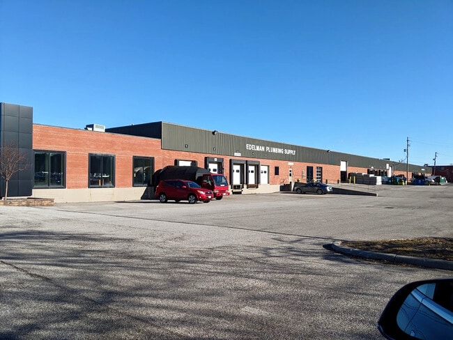
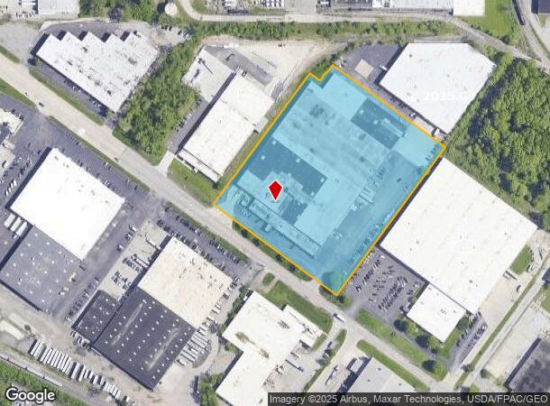
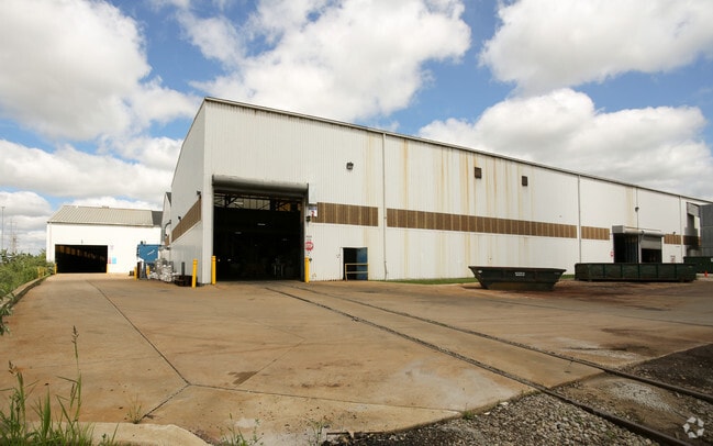
Property Record
26201 Richmond Rd, Bedford, OH 44146
Current Lease Availabilities
NEARBY LISTINGS FOR SALE OR LEASE
Property Detail
26201 Richmond Rd
791-13-030
20
Lightindustrial
Cuyahoga
X
Ohio
39035C0236E
20
2024
6.74 AC
2024
Warrensville Hts
133104
Cleveland
175,125 SF
Cleveland-Elyria, OH
DEMOGRAPHICS near 26201 Richmond Rd
1 Mile
3 Mile
5 Mile
2024 Total Population
4,594
48,500
141,224
2029 Population
4,554
47,460
138,141
Pop Growth 2024-2029
(0.87%)
(2.14%)
(2.18%)
Average Age
41
42
42
2024 Total Households
2,253
21,409
60,470
HH Growth 2024-2029
(0.98%)
(2.34%)
(2.34%)
Median Household Inc
$38,925
$52,914
$59,802
Avg Household Size
2.00
2.20
2.30
2024 Avg HH Vehicles
1.00
2.00
2.00
Median Home Value
$169,333
$157,077
$170,170
Median Year Built
1975
1963
1959
Nearby Places
Map Layers
Map Styles
 Street
 Aerial
- Restaurants
- Banks
- Shops
- Fitness
- Groceries
PUBLIC TRANSPORTATION
COMMUTER RAIL
Canal Exploration Center (National Park Scenic Railway - Cuyahoga Valley Scenic Railroad)
DRIVE
WALK
Distance
Canal Exploration Center (National Park Scenic Railway - Cuyahoga Valley Scenic Railroad)
19 min
9.2 mi
AIRPORT
Cleveland-Hopkins International
DRIVE
WALK
Distance
Cleveland-Hopkins International
32 min
20.9 mi
Freight Ports
Port of Toledo
DRIVE
WALK
Distance
Port of Toledo
146 min
121.8 mi
Nearby Properties
Address
Land Use
TOTAL SIZE
Lot Size
Zoning
Address
Land Use
TOTAL SIZE
Lot Size
Zoning
975,742 SF
42.03 AC
U-10
Address
Land Use
TOTAL SIZE
Lot Size
Zoning
418,553 SF
40.99 AC
Address
Land Use
TOTAL SIZE
Lot Size
Zoning
737,998 SF
53.07 AC
U-10
Address
Land Use
TOTAL SIZE
Lot Size
Zoning
130,621 SF
67.21 AC
I-2
Address
Land Use
TOTAL SIZE
Lot Size
Zoning
68.97 AC
C-1
Address
Land Use
TOTAL SIZE
Lot Size
Zoning
682,144 SF
99.58 AC
C-2
Address
Land Use
TOTAL SIZE
Lot Size
Zoning
90.68 AC
I-2
Address
Land Use
TOTAL SIZE
Lot Size
Zoning
323,733 SF
106.35 AC
MRC2
Address
Land Use
TOTAL SIZE
Lot Size
Zoning
233,767 SF
36.30 AC
U-1A1
Address
Land Use
TOTAL SIZE
Lot Size
Zoning
360,712 SF
55.30 AC
INS
Address
Land Use
TOTAL SIZE
Lot Size
Zoning
144,978 SF
31.14 AC
R-3
Address
Land Use
TOTAL SIZE
Lot Size
Zoning
232,078 SF
24.89 AC
U-7
Address
Land Use
TOTAL SIZE
Lot Size
Zoning
92,058 SF
31.37 AC
INS
Address
Land Use
TOTAL SIZE
Lot Size
Zoning
143,512 SF
16 AC
Address
Land Use
TOTAL SIZE
Lot Size
Zoning
11,808 SF
900.50 AC
1F-2
Address
Land Use
TOTAL SIZE
Lot Size
Zoning
204,701 SF
10.12 AC
Address
Land Use
TOTAL SIZE
Lot Size
Zoning
99,919 SF
17.91 AC
U-1A1
Address
Land Use
TOTAL SIZE
Lot Size
Zoning
18.38 AC
R2
Address
Land Use
TOTAL SIZE
Lot Size
Zoning
114,885 SF
1.21 AC
Address
Land Use
TOTAL SIZE
Lot Size
Zoning
196,429 SF
10.31 AC
U-7
Address
Land Use
TOTAL SIZE
Lot Size
Zoning
120,722 SF
20.55 AC
I/O
Address
Land Use
TOTAL SIZE
Lot Size
Zoning
838,521 SF
5.70 AC
I
Address
Land Use
TOTAL SIZE
Lot Size
Zoning
105,215 SF
5.42 AC
PF
Address
Land Use
TOTAL SIZE
Lot Size
Zoning
139,800 SF
3.62 AC
U-7A
Address
Land Use
TOTAL SIZE
Lot Size
Zoning
302,022 SF
19.04 AC
I-2
Address
Land Use
TOTAL SIZE
Lot Size
Zoning
81,564 SF
0.98 AC
Address
Land Use
TOTAL SIZE
Lot Size
Zoning
147,635 SF
15.14 AC
I-2
Address
Land Use
TOTAL SIZE
Lot Size
Zoning
324,644 SF
15.13 AC
I
Address
Land Use
TOTAL SIZE
Lot Size
Zoning
594,909 SF
39.82 AC
I-2
Address
Land Use
TOTAL SIZE
Lot Size
Zoning
115,932 SF
14.15 AC
U-10
The World's #1 Commercial Real Estate Marketplace
Connect with us
© 2026 CoStar Group
The information above has been obtained from sources believed reliable. While we do not doubt its accuracy we have not verified it and make no guarantee, warranty or representation about it. It is your responsibility to independently confirm its accuracy and completeness. Any projections, opinions, assumptions, or estimates used are for example only and do not represent the current or future performance of the property. The value of this transaction to you depends on tax and other factors which should be evaluated by your tax, financial, and legal advisors. You and your advisors should conduct a careful, independent investigation of the property to determine to your satisfaction the suitability of the property for your needs.