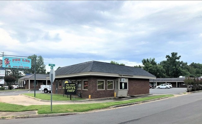
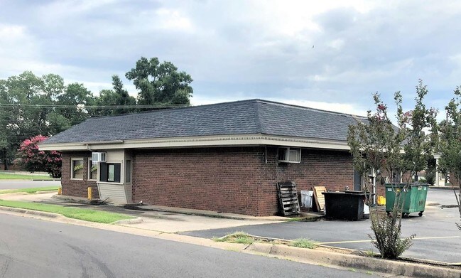
Property Record
2621 W Main St, Russellville, AR 72801
NEARBY LISTINGS FOR SALE OR LEASE
Property Detail
2621 W Main St
853-00104-000C
Rsvl By Sections
Commercialnec
PT NW SE CITY OF RUSSELLVILLE
X
Pope
05115C0370F
Arkansas
2024
0.87 AC
2025
Fort Smith/Russellville I-40
951503
Other Market Areas
12,400 SF
Russellville, AR
DEMOGRAPHICS near 2621 W Main St
1 Mile
3 Mile
5 Mile
2024 Total Population
4,208
25,523
37,458
2029 Population
4,335
26,104
38,139
Pop Growth 2024-2029
+ 3.02%
+ 2.28%
+ 1.82%
Average Age
41
37
37
2024 Total Households
1,802
9,765
14,273
HH Growth 2024-2029
+ 3.11%
+ 2.42%
+ 1.93%
Median Household Inc
$36,493
$39,369
$44,446
Avg Household Size
2.20
2.30
2.40
2024 Avg HH Vehicles
2.00
2.00
2.00
Median Home Value
$178,834
$160,537
$162,065
Median Year Built
1979
1981
1983
Nearby Places
Map Layers
Map Styles
 Street
 Aerial
- Restaurants
- Banks
- Shops
- Fitness
- Groceries
SALE & LEASE HISTORY
LISTING DATE
SALE/LEASE

Aug 09, 2019
For Sale
Nearby Properties
Address
Land Use
TOTAL SIZE
Lot Size
Zoning
Address
Land Use
TOTAL SIZE
Lot Size
Zoning
89,217 SF
5.87 AC
Address
Land Use
TOTAL SIZE
Lot Size
Zoning
68,660 SF
17.63 AC
Address
Land Use
TOTAL SIZE
Lot Size
Zoning
4,550 SF
7.26 AC
Address
Land Use
TOTAL SIZE
Lot Size
Zoning
2,001 SF
7.80 AC
Address
Land Use
TOTAL SIZE
Lot Size
Zoning
109,751 SF
15.40 AC
Address
Land Use
TOTAL SIZE
Lot Size
Zoning
18,448 SF
1.66 AC
Address
Land Use
TOTAL SIZE
Lot Size
Zoning
99,386 SF
7.30 AC
Address
Land Use
TOTAL SIZE
Lot Size
Zoning
69,646 SF
121.78 AC
Address
Land Use
TOTAL SIZE
Lot Size
Zoning
68,100 SF
1.55 AC
Address
Land Use
TOTAL SIZE
Lot Size
Zoning
65,141 SF
2.35 AC
Address
Land Use
TOTAL SIZE
Lot Size
Zoning
84,582 SF
5.47 AC
Address
Land Use
TOTAL SIZE
Lot Size
Zoning
39,992 SF
8.91 AC
Address
Land Use
TOTAL SIZE
Lot Size
Zoning
42,183 SF
6.92 AC
Address
Land Use
TOTAL SIZE
Lot Size
Zoning
47,403 SF
3.54 AC
Address
Land Use
TOTAL SIZE
Lot Size
Zoning
64,974 SF
7.33 AC
Address
Land Use
TOTAL SIZE
Lot Size
Zoning
124,946 SF
9.10 AC
Address
Land Use
TOTAL SIZE
Lot Size
Zoning
42,100 SF
4.70 AC
Address
Land Use
TOTAL SIZE
Lot Size
Zoning
58,103 SF
4.62 AC
Address
Land Use
TOTAL SIZE
Lot Size
Zoning
59,719 SF
6.25 AC
Address
Land Use
TOTAL SIZE
Lot Size
Zoning
41,245 SF
1.62 AC
Address
Land Use
TOTAL SIZE
Lot Size
Zoning
72,800 SF
3.43 AC
Address
Land Use
TOTAL SIZE
Lot Size
Zoning
40,937 SF
5.07 AC
Address
Land Use
TOTAL SIZE
Lot Size
Zoning
48,816 SF
5.01 AC
Address
Land Use
TOTAL SIZE
Lot Size
Zoning
39,050 SF
17.66 AC
Address
Land Use
TOTAL SIZE
Lot Size
Zoning
42,564 SF
0.11 AC
Address
Land Use
TOTAL SIZE
Lot Size
Zoning
22,974 SF
4.15 AC
Address
Land Use
TOTAL SIZE
Lot Size
Zoning
50,615 SF
2.04 AC
Address
Land Use
TOTAL SIZE
Lot Size
Zoning
25,610 SF
2.76 AC
Address
Land Use
TOTAL SIZE
Lot Size
Zoning
14,648 SF
0.79 AC
Address
Land Use
TOTAL SIZE
Lot Size
Zoning
38,016 SF
5.75 AC
The World's #1 Commercial Real Estate Marketplace
Connect with us
© 2025 CoStar Group
The information above has been obtained from sources believed reliable. While we do not doubt its accuracy we have not verified it and make no guarantee, warranty or representation about it. It is your responsibility to independently confirm its accuracy and completeness. Any projections, opinions, assumptions, or estimates used are for example only and do not represent the current or future performance of the property. The value of this transaction to you depends on tax and other factors which should be evaluated by your tax, financial, and legal advisors. You and your advisors should conduct a careful, independent investigation of the property to determine to your satisfaction the suitability of the property for your needs.