Property Record
26220 Mullinix Mill Rd, Mount Airy, MD 21771
NEARBY LISTINGS FOR SALE OR LEASE
-
-
View all Mount Airy listings for sale on LoopNet.com
Property Detail
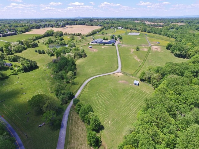
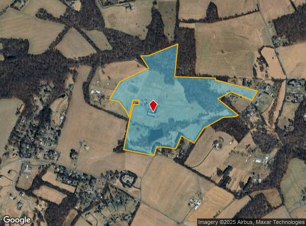
26220 Mullinix Mill Rd
12-03327737
Locust Level
Farms
PLEASANT PLAINS & ADD BROOKE GROVE
A
Montgomery
24013C0375D
Maryland
2024
100.71 AC
2025
Outlying Montgmery Cnty E
700208
Washington, DC
1,728 SF
Washington-Arlington-Alexandria, DC-VA-MD-WV
DEMOGRAPHICS near 26220 Mullinix Mill Rd
1 Mile
3 Mile
5 Mile
2024 Total Population
763
14,498
29,015
2029 Population
763
14,321
29,215
Pop Growth 2024-2029
0.00%
(1.22%)
+ 0.69%
Average Age
42
40
41
2024 Total Households
256
4,809
9,630
HH Growth 2024-2029
(0.39%)
(1.43%)
+ 0.60%
Median Household Inc
$128,226
$128,718
$138,607
Avg Household Size
3.00
2.90
2.90
2024 Avg HH Vehicles
2.00
2.00
3.00
Median Home Value
$578,629
$459,833
$513,942
Median Year Built
1976
1981
1983
Nearby Places
Map Layers
Map Styles
 Street
 Aerial
- Restaurants
- Banks
- Shops
- Fitness
- Groceries
PUBLIC TRANSPORTATION
AIRPORT
Baltimore/Washington International Thurgood Marshall
DRIVE
WALK
Distance
Baltimore/Washington International Thurgood Marshall
56 min
38.2 mi
Washington Dulles International
DRIVE
WALK
Distance
Washington Dulles International
69 min
46.7 mi
Freight Ports
Port of Baltimore
DRIVE
WALK
Distance
Port of Baltimore
57 min
38.7 mi
SALE & LEASE HISTORY
LISTING DATE
SALE/LEASE

Jun 09, 2017
For Sale
Nearby Properties
Address
Land Use
TOTAL SIZE
Lot Size
Zoning
Address
Land Use
TOTAL SIZE
Lot Size
Zoning
235,986 SF
26.49 AC
R200
Address
Land Use
TOTAL SIZE
Lot Size
Zoning
145,148 SF
15 AC
CRT17
Address
Land Use
TOTAL SIZE
Lot Size
Zoning
120,532 SF
19.68 AC
RC
Address
Land Use
TOTAL SIZE
Lot Size
Zoning
79,453 SF
10 AC
R200
Address
Land Use
TOTAL SIZE
Lot Size
Zoning
73,280 SF
3.43 AC
R200
Address
Land Use
TOTAL SIZE
Lot Size
Zoning
135.12 AC
AR
Address
Land Use
TOTAL SIZE
Lot Size
Zoning
48.66 AC
RC
Address
Land Use
TOTAL SIZE
Lot Size
Zoning
91,381 SF
9.37 AC
CRT1.
Address
Land Use
TOTAL SIZE
Lot Size
Zoning
53,121 SF
10 AC
R200
Address
Land Use
TOTAL SIZE
Lot Size
Zoning
53,239 SF
9.42 AC
CRT1.
Address
Land Use
TOTAL SIZE
Lot Size
Zoning
111,801 SF
5.98 AC
CRT1.
Address
Land Use
TOTAL SIZE
Lot Size
Zoning
36.58 AC
AR
Address
Land Use
TOTAL SIZE
Lot Size
Zoning
37,329 SF
8.88 AC
CRT1.
Address
Land Use
TOTAL SIZE
Lot Size
Zoning
45,000 SF
12.96 AC
AR
Address
Land Use
TOTAL SIZE
Lot Size
Zoning
16,938 SF
15.69 AC
AR
Address
Land Use
TOTAL SIZE
Lot Size
Zoning
31,064 SF
37.97 AC
RE2C
Address
Land Use
TOTAL SIZE
Lot Size
Zoning
18,016 SF
1.66 AC
CRT1.
Address
Land Use
TOTAL SIZE
Lot Size
Zoning
28,125 SF
1.22 AC
CRT1.
Address
Land Use
TOTAL SIZE
Lot Size
Zoning
34,755 SF
8.47 AC
CRT1.
Address
Land Use
TOTAL SIZE
Lot Size
Zoning
15,562 SF
7.04 AC
R200
Address
Land Use
TOTAL SIZE
Lot Size
Zoning
24.64 AC
AR
Address
Land Use
TOTAL SIZE
Lot Size
Zoning
10,125 SF
1.36 AC
CRT1.
Address
Land Use
TOTAL SIZE
Lot Size
Zoning
20,327 SF
0.82 AC
CRT17
Address
Land Use
TOTAL SIZE
Lot Size
Zoning
14,200 SF
2.50 AC
CRT1.
Address
Land Use
TOTAL SIZE
Lot Size
Zoning
18.52 AC
AR
Address
Land Use
TOTAL SIZE
Lot Size
Zoning
16,219 SF
5.36 AC
AR
Address
Land Use
TOTAL SIZE
Lot Size
Zoning
26,320 SF
0.70 AC
CRT17
Address
Land Use
TOTAL SIZE
Lot Size
Zoning
16,144 SF
2.15 AC
CRT17
Address
Land Use
TOTAL SIZE
Lot Size
Zoning
15,280 SF
85.57 AC
AR
Address
Land Use
TOTAL SIZE
Lot Size
Zoning
6,600 SF
6.24 AC
CRT1.
The World's #1 Commercial Real Estate Marketplace
Connect with us
© 2025 CoStar Group
The information above has been obtained from sources believed reliable. While we do not doubt its accuracy we have not verified it and make no guarantee, warranty or representation about it. It is your responsibility to independently confirm its accuracy and completeness. Any projections, opinions, assumptions, or estimates used are for example only and do not represent the current or future performance of the property. The value of this transaction to you depends on tax and other factors which should be evaluated by your tax, financial, and legal advisors. You and your advisors should conduct a careful, independent investigation of the property to determine to your satisfaction the suitability of the property for your needs.