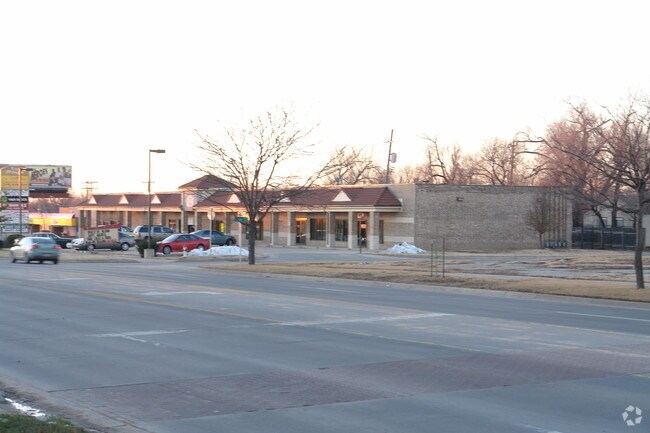
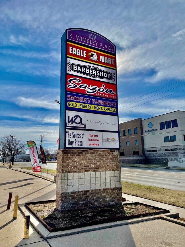
Property Record
2624 E 21St St N, Wichita, KS 67214
Current Lease Availabilities
NEARBY LISTINGS FOR SALE OR LEASE
Property Detail
2624 E 21St St N
Wichita, KS
Schrecks Add
122-03-0-43-06-014.00
LOT 14 SCHRECKS ADDITION
Storebuilding
Sedgwick
X
Kansas
20173C0356G
14
2024
0.21 AC
2025
Northeast
007800
Wichita
DEMOGRAPHICS near 2624 E 21St St N
1 Mile
3 Mile
5 Mile
2024 Total Population
12,784
81,320
206,294
2029 Population
13,357
83,551
211,633
Pop Growth 2024-2029
+ 4.48%
+ 2.74%
+ 2.59%
Average Age
34
36
38
2024 Total Households
4,393
31,950
85,030
HH Growth 2024-2029
+ 4.80%
+ 2.77%
+ 2.60%
Median Household Inc
$29,951
$45,664
$50,372
Avg Household Size
2.40
2.30
2.30
2024 Avg HH Vehicles
1.00
2.00
2.00
Median Home Value
$62,854
$119,220
$139,802
Median Year Built
1957
1957
1961
Nearby Places
- Restaurants
- Banks
- Shops
- Fitness
- Groceries
PUBLIC TRANSPORTATION
AIRPORT
Wichita Dwight D Eisenhower Ntl
DRIVE
WALK
Distance
Wichita Dwight D Eisenhower Ntl
18 min
11.5 mi
Freight Ports
Tulsa Port Of Catoosa
DRIVE
WALK
Distance
Tulsa Port Of Catoosa
209 min
195.5 mi
Nearby Properties
Address
Land Use
TOTAL SIZE
Lot Size
Zoning
Address
Land Use
TOTAL SIZE
Lot Size
Zoning
499,239 SF
18.70 AC
GO
Address
Land Use
TOTAL SIZE
Lot Size
Zoning
481,160 SF
63.37 AC
SF-5
Address
Land Use
TOTAL SIZE
Lot Size
Zoning
386,803 SF
13.33 AC
CBD
Address
Land Use
TOTAL SIZE
Lot Size
Zoning
346,728 SF
15.91 AC
SF-5
Address
Land Use
TOTAL SIZE
Lot Size
Zoning
576,707 SF
53.70 AC
B,LC
Address
Land Use
TOTAL SIZE
Lot Size
Zoning
179,764 SF
42.17 AC
SF-5,LI
Address
Land Use
TOTAL SIZE
Lot Size
Zoning
197,464 SF
4.05 AC
CBD
Address
Land Use
TOTAL SIZE
Lot Size
Zoning
227,462 SF
17.80 AC
TF-3
Address
Land Use
TOTAL SIZE
Lot Size
Zoning
84,757 SF
1.44 AC
GC
Address
Land Use
TOTAL SIZE
Lot Size
Zoning
148,617 SF
17.27 AC
SF-5
Address
Land Use
TOTAL SIZE
Lot Size
Zoning
104,331 SF
SF-5
Address
Land Use
TOTAL SIZE
Lot Size
Zoning
305,447 SF
46.77 AC
GI
Address
Land Use
TOTAL SIZE
Lot Size
Zoning
103,261 SF
5.49 AC
B
Address
Land Use
TOTAL SIZE
Lot Size
Zoning
180,527 SF
1.93 AC
LI
Address
Land Use
TOTAL SIZE
Lot Size
Zoning
143,110 SF
1.57 AC
LI
Address
Land Use
TOTAL SIZE
Lot Size
Zoning
186,902 SF
5.24 AC
SF-5
Address
Land Use
TOTAL SIZE
Lot Size
Zoning
110,839 SF
0.81 AC
CBD
Address
Land Use
TOTAL SIZE
Lot Size
Zoning
945,203 SF
9.53 AC
GO
Address
Land Use
TOTAL SIZE
Lot Size
Zoning
199,468 SF
24.45 AC
SF-5
Address
Land Use
TOTAL SIZE
Lot Size
Zoning
73,314 SF
3.18 AC
SF-5
Address
Land Use
TOTAL SIZE
Lot Size
Zoning
74,242 SF
23.99 AC
GC
Address
Land Use
TOTAL SIZE
Lot Size
Zoning
92,973 SF
5.52 AC
PUD
Address
Land Use
TOTAL SIZE
Lot Size
Zoning
111,805 SF
20.09 AC
SF-5
Address
Land Use
TOTAL SIZE
Lot Size
Zoning
84,452 SF
0.46 AC
B
Address
Land Use
TOTAL SIZE
Lot Size
Zoning
65,973 SF
5.39 AC
TF-3
Address
Land Use
TOTAL SIZE
Lot Size
Zoning
64,133 SF
5.93 AC
SF-5
Address
Land Use
TOTAL SIZE
Lot Size
Zoning
66,601 SF
3.85 AC
SF-5
Address
Land Use
TOTAL SIZE
Lot Size
Zoning
81,870 SF
3.70 AC
B,GC
Address
Land Use
TOTAL SIZE
Lot Size
Zoning
85,412 SF
1.21 AC
TF-3
The World's #1 Commercial Real Estate Marketplace
Connect with us
© 2025 CoStar Group
The information above has been obtained from sources believed reliable. While we do not doubt its accuracy we have not verified it and make no guarantee, warranty or representation about it. It is your responsibility to independently confirm its accuracy and completeness. Any projections, opinions, assumptions, or estimates used are for example only and do not represent the current or future performance of the property. The value of this transaction to you depends on tax and other factors which should be evaluated by your tax, financial, and legal advisors. You and your advisors should conduct a careful, independent investigation of the property to determine to your satisfaction the suitability of the property for your needs.