Property Record
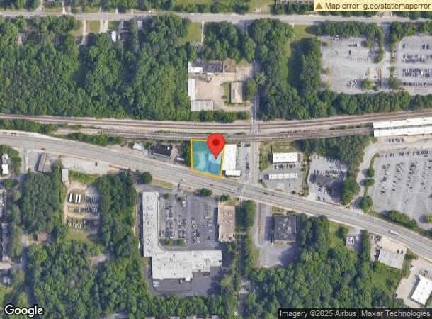
2625 Martin Luther King Jr Dr Nw, Atlanta, GA 30311
This Property Is For Sale
NEARBY LISTINGS FOR SALE OR LEASE
Property Detail
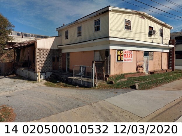
2625 Martin Luther King Jr Dr Nw
14-0205-0001-053-2
KA K S & B CABINETS PARCEL REVIEW ** SEE NOTES VACANT BLDG CB26 FC 10/23
Storebuilding
Fulton
X
Georgia
13121C0238F
0.48 AC
2024
Fulton District
2025
Atlanta
008000
Atlanta-Sandy Springs-Roswell, GA
5,402 SF
DEMOGRAPHICS near 2625 Martin Luther King Jr Dr Nw
1 Mile
3 Mile
5 Mile
2024 Total Population
11,730
78,241
229,441
2029 Population
12,482
82,537
239,842
Pop Growth 2024-2029
+ 6.41%
+ 5.49%
+ 4.53%
Average Age
38
39
37
2024 Total Households
4,699
31,399
93,405
HH Growth 2024-2029
+ 6.36%
+ 5.58%
+ 4.87%
Median Household Inc
$30,215
$42,490
$52,176
Avg Household Size
2.40
2.40
2.20
2024 Avg HH Vehicles
1.00
1.00
1.00
Median Home Value
$171,280
$237,075
$280,263
Median Year Built
1970
1965
1981
Nearby Places
- Restaurants
- Banks
- Shops
- Fitness
- Groceries
PUBLIC TRANSPORTATION
TRANSIT/SUBWAY
Hamilton E Holmes (Blue Line - Metropolitan Atlanta Rapid Transit Authority (MARTA))
DRIVE
WALK
Distance
Hamilton E Holmes (Blue Line - Metropolitan Atlanta Rapid Transit Authority (MARTA))
1 min
5 min
0.3 mi
COMMUTER RAIL
Atlanta (Crescent - Amtrak)
DRIVE
WALK
Distance
Atlanta (Crescent - Amtrak)
16 min
8.4 mi
AIRPORT
Hartsfield - Jackson Atlanta International
DRIVE
WALK
Distance
Hartsfield - Jackson Atlanta International
22 min
13.6 mi
Freight Ports
Georgia Ports - Savannah
DRIVE
WALK
Distance
Georgia Ports - Savannah
285 min
252.9 mi
Nearby Properties
Address
Land Use
TOTAL SIZE
Lot Size
Zoning
Address
Land Use
TOTAL SIZE
Lot Size
Zoning
Address
Land Use
TOTAL SIZE
Lot Size
Zoning
354,710 SF
25.27 AC
R5
Address
Land Use
TOTAL SIZE
Lot Size
Zoning
499,198 SF
9.49 AC
RG3
Address
Land Use
TOTAL SIZE
Lot Size
Zoning
1,057,380 SF
17.43 AC
C1
Address
Land Use
TOTAL SIZE
Lot Size
Zoning
6,603,740 SF
24.69 AC
RG3
Address
Land Use
TOTAL SIZE
Lot Size
Zoning
19.31 AC
R4
Address
Land Use
TOTAL SIZE
Lot Size
Zoning
814,536 SF
37 AC
R3
Address
Land Use
TOTAL SIZE
Lot Size
Zoning
1,825,146 SF
16.16 AC
RG3
Address
Land Use
TOTAL SIZE
Lot Size
Zoning
237,515 SF
16.68 AC
C2
Address
Land Use
TOTAL SIZE
Lot Size
Zoning
34.86 AC
R4
Address
Land Use
TOTAL SIZE
Lot Size
Zoning
70.35 AC
R3
Address
Land Use
TOTAL SIZE
Lot Size
Zoning
520,556 SF
5.47 AC
RG2
Address
Land Use
TOTAL SIZE
Lot Size
Zoning
77.56 AC
RG3
Address
Land Use
TOTAL SIZE
Lot Size
Zoning
1,477,770 SF
13.60 AC
C1
Address
Land Use
TOTAL SIZE
Lot Size
Zoning
756 SF
52.20 AC
R4
Address
Land Use
TOTAL SIZE
Lot Size
Zoning
229,860 SF
4.27 AC
RG2
Address
Land Use
TOTAL SIZE
Lot Size
Zoning
903,588 SF
6.94 AC
RG3
Address
Land Use
TOTAL SIZE
Lot Size
Zoning
874,924 SF
10 AC
C1
Address
Land Use
TOTAL SIZE
Lot Size
Zoning
55,788 SF
44.07 AC
I1
Address
Land Use
TOTAL SIZE
Lot Size
Zoning
130,000 SF
4.28 AC
R4
Address
Land Use
TOTAL SIZE
Lot Size
Zoning
191,540 SF
7.74 AC
RG3
Address
Land Use
TOTAL SIZE
Lot Size
Zoning
1,454,400 SF
14.81 AC
RG3
Address
Land Use
TOTAL SIZE
Lot Size
Zoning
60.64 AC
R5
Address
Land Use
TOTAL SIZE
Lot Size
Zoning
Address
Land Use
TOTAL SIZE
Lot Size
Zoning
191.75 AC
R4
Address
Land Use
TOTAL SIZE
Lot Size
Zoning
6,245,680 SF
13.07 AC
RG3
Address
Land Use
TOTAL SIZE
Lot Size
Zoning
442,740 SF
5.46 AC
RG3
Address
Land Use
TOTAL SIZE
Lot Size
Zoning
156,148 SF
27.07 AC
C1
Address
Land Use
TOTAL SIZE
Lot Size
Zoning
122.60 AC
R3
Address
Land Use
TOTAL SIZE
Lot Size
Zoning
18.21 AC
R4
The World's #1 Commercial Real Estate Marketplace
Connect with us
© 2025 CoStar Group
The information above has been obtained from sources believed reliable. While we do not doubt its accuracy we have not verified it and make no guarantee, warranty or representation about it. It is your responsibility to independently confirm its accuracy and completeness. Any projections, opinions, assumptions, or estimates used are for example only and do not represent the current or future performance of the property. The value of this transaction to you depends on tax and other factors which should be evaluated by your tax, financial, and legal advisors. You and your advisors should conduct a careful, independent investigation of the property to determine to your satisfaction the suitability of the property for your needs.