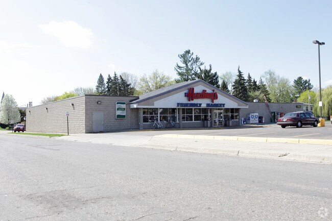
Property Record
2626 E Main St, Kalamazoo, MI 49048

Property Detail
2626 E Main St
06-13-120-042
4204380 3906 13 120 042 VOSLERS ADDITION LOTS 2 THRU 9 AND LOTS 27 & 28 BLK 8 . ALSO UNPLATTED LAND DESC AS BEG AT THE NE COR
Commercialnec
Kalamazoo
C-1
Michigan
B and X Area of moderate flood hazard, usually the area between the limits of the 100-year and 500-year floods.
2-28
2025
1.39 AC
2025
NE Kalamazoo County
005502
West Michigan
16,630 SF
Kalamazoo-Portage, MI
NEARBY LISTINGS FOR SALE OR LEASE
DEMOGRAPHICS near 2626 E Main St
1 mile
3 mile
5 mile
2025 Total Population
8,443
60,626
120,454
2030 Population
8,381
62,124
123,260
Pop Growth 2025-2030
(0.73%)
+ 2.47%
+ 2.33%
Average Age
37
37
36
2025 Total Households
3,359
25,689
49,288
HH Growth 2025-2030
(0.98%)
+ 2.79%
+ 2.54%
Median Household Inc
$51,491
$52,918
$55,573
Avg Household Size
2.40
2.20
2.20
2025 Avg HH Vehicles
2.00
2.00
2.00
Median Home Value
$132,750
$156,107
$182,402
Median Year Built
1953
1957
1965
Nearby Places
Map Layers
Map Styles
 Street
 Aerial
Layers
 Traffic
 Biking
Places
Listings with unknown addresses are not visible on the map
- Restaurants
- Banks
- Shops
- Fitness
- Groceries
PUBLIC TRANSPORTATION
COMMUTER RAIL
Drive
Walk
Distance
5 min
2.4 mi
AIRPORT
Kalamazoo/Battle Creek International
Drive
Walk
Distance
Kalamazoo/Battle Creek International
18 min
6.7 mi
Nearby Properties
Address
Land Use
TOTAL SIZE
Lot Size
Zoning
Address
Land Use
TOTAL SIZE
Lot Size
Zoning
632,218 SF
10.84 AC
M-1
Address
Land Use
TOTAL SIZE
Lot Size
Zoning
429,500 SF
2 AC
CCBD
Address
Land Use
TOTAL SIZE
Lot Size
Zoning
877,422 SF
38.18 AC
M-2
Address
Land Use
TOTAL SIZE
Lot Size
Zoning
20.94 AC
Address
Land Use
TOTAL SIZE
Lot Size
Zoning
110,686 SF
9.45 AC
CCBD
Address
Land Use
TOTAL SIZE
Lot Size
Zoning
390,900 SF
14 AC
I-M IND
Address
Land Use
TOTAL SIZE
Lot Size
Zoning
275,595 SF
0.65 AC
CCBD
Address
Land Use
TOTAL SIZE
Lot Size
Zoning
Address
Land Use
TOTAL SIZE
Lot Size
Zoning
50,826 SF
0.79 AC
CCBD
Address
Land Use
TOTAL SIZE
Lot Size
Zoning
185,107 SF
25.12 AC
RM
Address
Land Use
TOTAL SIZE
Lot Size
Zoning
196,221 SF
26.26 AC
RM
Address
Land Use
TOTAL SIZE
Lot Size
Zoning
185,092 SF
26.86 AC
RM
Address
Land Use
TOTAL SIZE
Lot Size
Zoning
12.58 AC
Address
Land Use
TOTAL SIZE
Lot Size
Zoning
274,412 SF
12.10 AC
RM-1
Address
Land Use
TOTAL SIZE
Lot Size
Zoning
226,051 SF
44.98 AC
B-2
Address
Land Use
TOTAL SIZE
Lot Size
Zoning
99,092 SF
1.45 AC
CCBD
Address
Land Use
TOTAL SIZE
Lot Size
Zoning
98,401 SF
2.94 AC
RM-15
Address
Land Use
TOTAL SIZE
Lot Size
Zoning
217,600 SF
21.30 AC
N/A
Address
Land Use
TOTAL SIZE
Lot Size
Zoning
171,772 SF
0.68 AC
CCBD
Address
Land Use
TOTAL SIZE
Lot Size
Zoning
133,600 SF
15.08 AC
B-1
Address
Land Use
TOTAL SIZE
Lot Size
Zoning
193,194 SF
23.96 AC
B-3
Address
Land Use
TOTAL SIZE
Lot Size
Zoning
99,017 SF
9.42 AC
RM
Address
Land Use
TOTAL SIZE
Lot Size
Zoning
185,528 SF
17.20 AC
R5
Address
Land Use
TOTAL SIZE
Lot Size
Zoning
49,894 SF
7.09 AC
RM-15
Address
Land Use
TOTAL SIZE
Lot Size
Zoning
183,820 SF
5.24 AC
CC
Address
Land Use
TOTAL SIZE
Lot Size
Zoning
129,780 SF
0.78 AC
CCBD
Address
Land Use
TOTAL SIZE
Lot Size
Zoning
98,360 SF
13.58 AC
R4
Address
Land Use
TOTAL SIZE
Lot Size
Zoning
42,386 SF
1.55 AC
RM-15
Address
Land Use
TOTAL SIZE
Lot Size
Zoning
143,760 SF
10.25 AC
M-2
Address
Land Use
TOTAL SIZE
Lot Size
Zoning
118,104 SF
10.40 AC
R4
The World's #1 Commercial Real Estate Marketplace
Connect with us
© 2026 CoStar Group
The information above has been obtained from sources believed reliable. While we do not doubt its accuracy we have not verified it and make no guarantee, warranty or representation about it. It is your responsibility to independently confirm its accuracy and completeness. Any projections, opinions, assumptions, or estimates used are for example only and do not represent the current or future performance of the property. The value of this transaction to you depends on tax and other factors which should be evaluated by your tax, financial, and legal advisors. You and your advisors should conduct a careful, independent investigation of the property to determine to your satisfaction the suitability of the property for your needs.