Property Record
2626 Ne 39Th Ave, Gainesville, FL 32609
NEARBY LISTINGS FOR SALE OR LEASE
-
-
View all Gainesville listings for sale on LoopNet.com
Property Detail
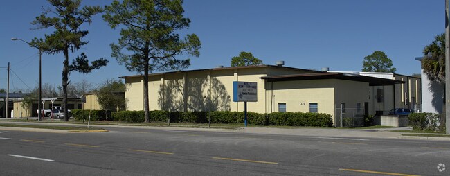
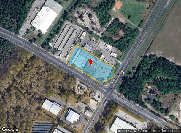
2626 Ne 39Th Ave
08198-007-002
Haile Lt 65 A Condo
Warehouse
COM NE COR SEC S 657.02 FT N 58 DEG W 376.15 FT S 31 DEG W 208.71 FT POB S 31 DEG W 229.46 FT TO NLY R/W 39TH AVE ELY ALG R/W 473.26 FT TO E RR/W N 60 DEG E ALG RR/W 262.27 FT N 58 DEG W 608.71 FT POB LESS ADDN R/W SR-24 OR 523/107 & OR 1681/1322 LES
A
Alachua
12001C0316D
Florida
2025
2.75 AC
2025
Northwest Gainesville
001902
Other Market Areas
33,200 SF
Gainesville, FL
DEMOGRAPHICS near 2626 Ne 39Th Ave
1 Mile
3 Mile
5 Mile
2024 Total Population
1,406
27,304
84,010
2029 Population
1,496
29,068
88,168
Pop Growth 2024-2029
+ 6.40%
+ 6.46%
+ 4.95%
Average Age
34
38
35
2024 Total Households
551
10,887
32,458
HH Growth 2024-2029
+ 6.53%
+ 6.31%
+ 5.23%
Median Household Inc
$40,075
$36,945
$40,900
Avg Household Size
2.60
2.20
2.20
2024 Avg HH Vehicles
1.00
1.00
2.00
Median Home Value
$156,451
$145,273
$173,847
Median Year Built
1974
1972
1976
Nearby Places
Map Layers
Map Styles
 Street
 Aerial
- Restaurants
- Banks
- Shops
- Fitness
- Groceries
PUBLIC TRANSPORTATION
AIRPORT
Gainesville Regional
DRIVE
WALK
Distance
Gainesville Regional
6 min
1.7 mi
Freight Ports
Jacksonville Port
DRIVE
WALK
Distance
Jacksonville Port
92 min
71.5 mi
Nearby Properties
Address
Land Use
TOTAL SIZE
Lot Size
Zoning
Address
Land Use
TOTAL SIZE
Lot Size
Zoning
25.64 AC
PS
Address
Land Use
TOTAL SIZE
Lot Size
Zoning
60,480 SF
117.68 AC
PS
Address
Land Use
TOTAL SIZE
Lot Size
Zoning
346,154 SF
22.02 AC
U6
Address
Land Use
TOTAL SIZE
Lot Size
Zoning
308,599 SF
639 AC
A
Address
Land Use
TOTAL SIZE
Lot Size
Zoning
341,625 SF
1,093.63 AC
AF
Address
Land Use
TOTAL SIZE
Lot Size
Zoning
125,495 SF
19.11 AC
ED
Address
Land Use
TOTAL SIZE
Lot Size
Zoning
3 SF
14.81 AC
ED
Address
Land Use
TOTAL SIZE
Lot Size
Zoning
93,004 SF
37.39 AC
ED
Address
Land Use
TOTAL SIZE
Lot Size
Zoning
85,476 SF
17.92 AC
MP
Address
Land Use
TOTAL SIZE
Lot Size
Zoning
41,000 SF
155.49 AC
PS
Address
Land Use
TOTAL SIZE
Lot Size
Zoning
90,488 SF
14.67 AC
ED
Address
Land Use
TOTAL SIZE
Lot Size
Zoning
174,781 SF
16.83 AC
U8
Address
Land Use
TOTAL SIZE
Lot Size
Zoning
76,925 SF
19.55 AC
A
Address
Land Use
TOTAL SIZE
Lot Size
Zoning
84,469 SF
13.37 AC
ED
Address
Land Use
TOTAL SIZE
Lot Size
Zoning
118,896 SF
7.16 AC
PS
Address
Land Use
TOTAL SIZE
Lot Size
Zoning
169,796 SF
15.61 AC
U8
Address
Land Use
TOTAL SIZE
Lot Size
Zoning
351,294 SF
94.41 AC
ED
Address
Land Use
TOTAL SIZE
Lot Size
Zoning
34.32 AC
PS
Address
Land Use
TOTAL SIZE
Lot Size
Zoning
177,604 SF
41.41 AC
I2
Address
Land Use
TOTAL SIZE
Lot Size
Zoning
136,094 SF
16.11 AC
ED
Address
Land Use
TOTAL SIZE
Lot Size
Zoning
64,138 SF
8.43 AC
I2
Address
Land Use
TOTAL SIZE
Lot Size
Zoning
64,507 SF
15.91 AC
ED
Address
Land Use
TOTAL SIZE
Lot Size
Zoning
211,600 SF
31.73 AC
MU2
Address
Land Use
TOTAL SIZE
Lot Size
Zoning
118,740 SF
11.16 AC
I1
Address
Land Use
TOTAL SIZE
Lot Size
Zoning
419,552 SF
10.28 AC
PS
Address
Land Use
TOTAL SIZE
Lot Size
Zoning
113,378 SF
13.75 AC
RMF6
Address
Land Use
TOTAL SIZE
Lot Size
Zoning
138,032 SF
32 AC
MH
Address
Land Use
TOTAL SIZE
Lot Size
Zoning
154,130 SF
24.65 AC
I2
Address
Land Use
TOTAL SIZE
Lot Size
Zoning
54,938 SF
6.02 AC
PS
Address
Land Use
TOTAL SIZE
Lot Size
Zoning
93,651 SF
6.50 AC
RMF6
The World's #1 Commercial Real Estate Marketplace
Connect with us
© 2025 CoStar Group
The information above has been obtained from sources believed reliable. While we do not doubt its accuracy we have not verified it and make no guarantee, warranty or representation about it. It is your responsibility to independently confirm its accuracy and completeness. Any projections, opinions, assumptions, or estimates used are for example only and do not represent the current or future performance of the property. The value of this transaction to you depends on tax and other factors which should be evaluated by your tax, financial, and legal advisors. You and your advisors should conduct a careful, independent investigation of the property to determine to your satisfaction the suitability of the property for your needs.