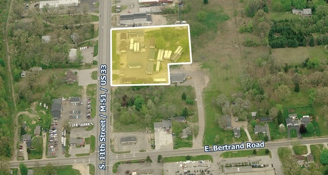
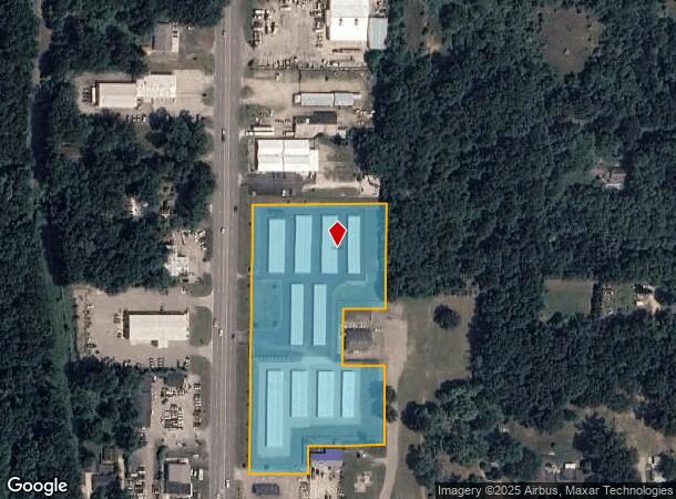
Property Record
2627 S 11Th St, Niles, MI 49120
NEARBY LISTINGS FOR SALE OR LEASE
-
-
View all Niles listings for sale on LoopNet.com
Property Detail
2627 S 11Th St
11-14-0860-0034-07-0
COMBINED ON 05/15/2019 FROM 14-0860-0034-06-3, 14-0860-0037-01-1; PT OF BLK 34 VILLAGE OF BERTRAND PLAT OF 1836 COM 100' N00DEG14'E OF NE COR OF US 31 & CHICAGO RD (NOW BERTRAND RD) TH N0DEG08'40E (REC AS N00DEG14'E) 715.3' TH S89DEG53'20"E 355.71' T
Publicstorage
Berrien
X
Michigan
18141C0088D
5.10 AC
2024
Michigan Southwest Area
2025
Other Market Areas
021100
Niles-Benton Harbor, MI
48,100 SF
DEMOGRAPHICS near 2627 S 11Th St
1 Mile
3 Mile
5 Mile
2024 Total Population
2,950
19,736
63,678
2029 Population
2,872
19,381
62,674
Pop Growth 2024-2029
(2.64%)
(1.80%)
(1.58%)
Average Age
43
43
42
2024 Total Households
1,143
7,896
25,940
HH Growth 2024-2029
(2.97%)
(1.93%)
(1.66%)
Median Household Inc
$58,299
$77,200
$70,234
Avg Household Size
2.30
2.40
2.30
2024 Avg HH Vehicles
2.00
2.00
2.00
Median Home Value
$141,550
$178,007
$178,346
Median Year Built
1960
1973
1973
Nearby Places
Map Layers
Map Styles
 Street
 Aerial
- Restaurants
- Banks
- Shops
- Fitness
- Groceries
PUBLIC TRANSPORTATION
COMMUTER RAIL
Niles Amtrak Station (Blue Water - Amtrak, Wolverine - Amtrak)
DRIVE
WALK
Distance
Niles Amtrak Station (Blue Water - Amtrak, Wolverine - Amtrak)
8 min
4.6 mi
South Bend Airport Station (South Shore Line - Northern Indiana Commuter Transportation District (South Shore Line))
DRIVE
WALK
Distance
South Bend Airport Station (South Shore Line - Northern Indiana Commuter Transportation District (South Shore Line))
18 min
8.7 mi
AIRPORT
South Bend International
DRIVE
WALK
Distance
South Bend International
28 min
11.7 mi
Freight Ports
Port Milwaukee
DRIVE
WALK
Distance
Port Milwaukee
222 min
182.7 mi
Nearby Properties
Address
Land Use
TOTAL SIZE
Lot Size
Zoning
Address
Land Use
TOTAL SIZE
Lot Size
Zoning
Address
Land Use
TOTAL SIZE
Lot Size
Zoning
33,936 SF
1.84 AC
GB
Address
Land Use
TOTAL SIZE
Lot Size
Zoning
164,768 SF
24.57 AC
GB
Address
Land Use
TOTAL SIZE
Lot Size
Zoning
215,252 SF
18.33 AC
Address
Land Use
TOTAL SIZE
Lot Size
Zoning
124,568 SF
11.40 AC
R-2
Address
Land Use
TOTAL SIZE
Lot Size
Zoning
135,152 SF
8.76 AC
GB
Address
Land Use
TOTAL SIZE
Lot Size
Zoning
58,646 SF
1 AC
Address
Land Use
TOTAL SIZE
Lot Size
Zoning
93,452 SF
44 SF
Address
Land Use
TOTAL SIZE
Lot Size
Zoning
300,000 SF
65.30 AC
I
Address
Land Use
TOTAL SIZE
Lot Size
Zoning
26,140 SF
131 SF
Address
Land Use
TOTAL SIZE
Lot Size
Zoning
65,358 SF
6.02 AC
R-2
Address
Land Use
TOTAL SIZE
Lot Size
Zoning
49,914 SF
6.18 AC
GB
Address
Land Use
TOTAL SIZE
Lot Size
Zoning
52,528 SF
2.41 AC
Address
Land Use
TOTAL SIZE
Lot Size
Zoning
23,208 SF
44 SF
Address
Land Use
TOTAL SIZE
Lot Size
Zoning
114,835 SF
27.11 AC
LDR
Address
Land Use
TOTAL SIZE
Lot Size
Zoning
61,402 SF
2.49 AC
MDR
Address
Land Use
TOTAL SIZE
Lot Size
Zoning
35,016 SF
3.50 AC
Address
Land Use
TOTAL SIZE
Lot Size
Zoning
5,075 SF
36.90 AC
R-3
Address
Land Use
TOTAL SIZE
Lot Size
Zoning
19,626 SF
3.10 AC
GB
Address
Land Use
TOTAL SIZE
Lot Size
Zoning
22,657 SF
44 SF
Address
Land Use
TOTAL SIZE
Lot Size
Zoning
42,840 SF
1.65 AC
GB
Address
Land Use
TOTAL SIZE
Lot Size
Zoning
24,984 SF
5 AC
R-2
Address
Land Use
TOTAL SIZE
Lot Size
Zoning
31,932 SF
0.90 AC
RC
Address
Land Use
TOTAL SIZE
Lot Size
Zoning
14,487 SF
2.43 AC
GB
Address
Land Use
TOTAL SIZE
Lot Size
Zoning
113,964 SF
9.85 AC
GB
Address
Land Use
TOTAL SIZE
Lot Size
Zoning
61,128 SF
7.63 AC
GB
Address
Land Use
TOTAL SIZE
Lot Size
Zoning
2,580 SF
70.66 AC
Address
Land Use
TOTAL SIZE
Lot Size
Zoning
77,338 SF
7.98 AC
Address
Land Use
TOTAL SIZE
Lot Size
Zoning
58,381 SF
5.92 AC
GB
The World's #1 Commercial Real Estate Marketplace
Connect with us
© 2026 CoStar Group
The information above has been obtained from sources believed reliable. While we do not doubt its accuracy we have not verified it and make no guarantee, warranty or representation about it. It is your responsibility to independently confirm its accuracy and completeness. Any projections, opinions, assumptions, or estimates used are for example only and do not represent the current or future performance of the property. The value of this transaction to you depends on tax and other factors which should be evaluated by your tax, financial, and legal advisors. You and your advisors should conduct a careful, independent investigation of the property to determine to your satisfaction the suitability of the property for your needs.