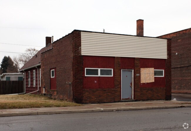
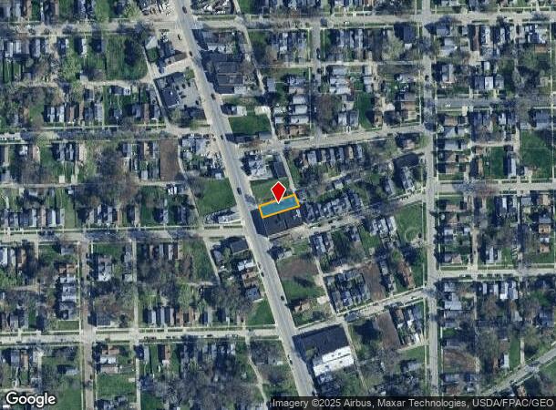
Property Record
2628-2704 Lagrange St, Toledo, OH 43608

NEARBY LISTINGS FOR SALE OR LEASE
Property Detail
2628-2704 Lagrange St
Toledo, OH
Moderwells Addition
10-19341
MODERWELLS ADDITION LOT 13
Storebuilding
Lucas
X
Ohio
39095C0091E
13
0
0.11 AC
2025
CBD
001900
Toledo
DEMOGRAPHICS near 2628-2704 Lagrange St
1 Mile
3 Mile
5 Mile
2024 Total Population
16,558
101,617
218,021
2029 Population
16,832
102,378
217,217
Pop Growth 2024-2029
+ 1.65%
+ 0.75%
(0.37%)
Average Age
37
37
38
2024 Total Households
6,753
42,008
91,180
HH Growth 2024-2029
+ 1.42%
+ 0.71%
(0.44%)
Median Household Inc
$26,519
$33,407
$41,548
Avg Household Size
2.20
2.20
2.20
2024 Avg HH Vehicles
1.00
1.00
2.00
Median Home Value
$61,439
$65,627
$88,472
Median Year Built
1947
1947
1951
Nearby Places
Map Layers
Map Styles
 Street
 Aerial
- Restaurants
- Banks
- Shops
- Fitness
- Groceries
PUBLIC TRANSPORTATION
COMMUTER RAIL
DRIVE
WALK
Distance
7 min
3.1 mi
AIRPORT
Eugene F Kranz Toledo Express
DRIVE
WALK
Distance
Eugene F Kranz Toledo Express
39 min
21.7 mi
Nearby Properties
Address
Land Use
TOTAL SIZE
Lot Size
Zoning
Address
Land Use
TOTAL SIZE
Lot Size
Zoning
3,101,694 SF
35.64 AC
10-IC
Address
Land Use
TOTAL SIZE
Lot Size
Zoning
1,046,727 SF
0.41 AC
10-IC
Address
Land Use
TOTAL SIZE
Lot Size
Zoning
569,999 SF
45.25 AC
10-MX
Address
Land Use
TOTAL SIZE
Lot Size
Zoning
277,862 SF
3 AC
10-CD
Address
Land Use
TOTAL SIZE
Lot Size
Zoning
169.42 AC
10-IG
Address
Land Use
TOTAL SIZE
Lot Size
Zoning
314,826 SF
10.28 AC
10-CM
Address
Land Use
TOTAL SIZE
Lot Size
Zoning
625,485 SF
2 AC
10-MX
Address
Land Use
TOTAL SIZE
Lot Size
Zoning
111,471 SF
6.17 AC
10-CD
Address
Land Use
TOTAL SIZE
Lot Size
Zoning
171,946 SF
0.17 AC
10-IC
Address
Land Use
TOTAL SIZE
Lot Size
Zoning
Address
Land Use
TOTAL SIZE
Lot Size
Zoning
328,568 SF
16.37 AC
10-CO
Address
Land Use
TOTAL SIZE
Lot Size
Zoning
243,165 SF
3.63 AC
10-CD
Address
Land Use
TOTAL SIZE
Lot Size
Zoning
1.74 AC
10-CD
Address
Land Use
TOTAL SIZE
Lot Size
Zoning
296,348 SF
1 AC
10-CO
Address
Land Use
TOTAL SIZE
Lot Size
Zoning
169.42 AC
10-IG
Address
Land Use
TOTAL SIZE
Lot Size
Zoning
375,323 SF
10-IC
Address
Land Use
TOTAL SIZE
Lot Size
Zoning
182,983 SF
2 AC
10-CD
Address
Land Use
TOTAL SIZE
Lot Size
Zoning
14,824 SF
54.18 AC
10-MX
Address
Land Use
TOTAL SIZE
Lot Size
Zoning
317,139 SF
25.80 AC
10-IC
Address
Land Use
TOTAL SIZE
Lot Size
Zoning
68,517 SF
1.56 AC
10-RM36
Address
Land Use
TOTAL SIZE
Lot Size
Zoning
172,044 SF
12.78 AC
10-MX
Address
Land Use
TOTAL SIZE
Lot Size
Zoning
390,272 SF
5 AC
10-CD
Address
Land Use
TOTAL SIZE
Lot Size
Zoning
228,692 SF
10.45 AC
10-RM36
Address
Land Use
TOTAL SIZE
Lot Size
Zoning
202,118 SF
1.50 AC
10-CD
Address
Land Use
TOTAL SIZE
Lot Size
Zoning
232,758 SF
2 AC
10-CO
Address
Land Use
TOTAL SIZE
Lot Size
Zoning
297,666 SF
4 AC
10-CO
Address
Land Use
TOTAL SIZE
Lot Size
Zoning
132,690 SF
5 AC
10-CO
Address
Land Use
TOTAL SIZE
Lot Size
Zoning
77,274 SF
4 AC
10-CO
Address
Land Use
TOTAL SIZE
Lot Size
Zoning
158,288 SF
1.22 AC
10-CO
Address
Land Use
TOTAL SIZE
Lot Size
Zoning
370,650 SF
13.65 AC
10-MX
The World's #1 Commercial Real Estate Marketplace
Connect with us
© 2026 CoStar Group
The information above has been obtained from sources believed reliable. While we do not doubt its accuracy we have not verified it and make no guarantee, warranty or representation about it. It is your responsibility to independently confirm its accuracy and completeness. Any projections, opinions, assumptions, or estimates used are for example only and do not represent the current or future performance of the property. The value of this transaction to you depends on tax and other factors which should be evaluated by your tax, financial, and legal advisors. You and your advisors should conduct a careful, independent investigation of the property to determine to your satisfaction the suitability of the property for your needs.