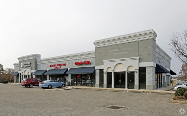
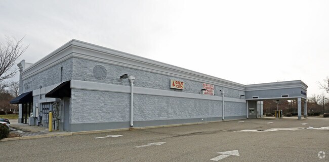
Property Record
2628 Taylor Rd, Chesapeake, VA 23321

Property Detail
2628 Taylor Rd
0100000001730
PAR 1B RESUB PLT OF PAR 1 & 2 CHESAPEAKE WEST 1.02
Storebuilding
Chesapeake City
O-I: OFFIC
Virginia
B and X Area of moderate flood hazard, usually the area between the limits of the 100-year and 500-year floods.
1.02 AC
2024
Chesapeake Square
2025
Hampton Roads
021505
Virginia Beach-Chesapeake-Norfolk, VA-NC
7,468 SF
NEARBY LISTINGS FOR SALE OR LEASE
DEMOGRAPHICS near 2628 Taylor Rd
1 mile
3 mile
5 mile
2024 Total Population
7,432
67,071
140,360
2029 Population
7,580
67,809
142,391
Pop Growth 2024-2029
+ 1.99%
+ 1.10%
+ 1.45%
Average Age
40
39
39
2024 Total Households
2,880
26,292
54,307
HH Growth 2024-2029
+ 2.12%
+ 1.10%
+ 1.42%
Median Household Inc
$93,590
$86,116
$78,445
Avg Household Size
2.60
2.50
2.50
2024 Avg HH Vehicles
2.00
2.00
2.00
Median Home Value
$358,528
$323,150
$307,320
Median Year Built
1988
1980
1979
Nearby Places
Map Layers
Map Styles
 Street
 Aerial
Transit
 Traffic
 Biking
Places
Listings with unknown addresses are not visible on the map
- Restaurants
- Banks
- Shops
- Fitness
- Groceries
PUBLIC TRANSPORTATION
COMMUTER RAIL
Drive
Walk
Distance
20 min
9.4 mi
AIRPORT
Norfolk International
Drive
Walk
Distance
Norfolk International
32 min
15.8 mi
Newport News/Williamsburg International
Drive
Walk
Distance
Newport News/Williamsburg International
40 min
27.5 mi
Freight Ports
Virginia Port Authority - Portsmouth
Drive
Walk
Distance
Virginia Port Authority - Portsmouth
20 min
7.6 mi
Nearby Properties
Address
Land Use
TOTAL SIZE
Lot Size
Zoning
Address
Land Use
TOTAL SIZE
Lot Size
Zoning
637,266 SF
73.24 AC
PUD: PLANN
Address
Land Use
TOTAL SIZE
Lot Size
Zoning
285,162 SF
101.91 AC
R10S: RESI
Address
Land Use
TOTAL SIZE
Lot Size
Zoning
359,146 SF
16.95 AC
RMF1: MULT
Address
Land Use
TOTAL SIZE
Lot Size
Zoning
30.85 AC
PLANNED DE
Address
Land Use
TOTAL SIZE
Lot Size
Zoning
71,039 SF
22.69 AC
R10S: RESI
Address
Land Use
TOTAL SIZE
Lot Size
Zoning
6,446 SF
8.76 AC
MIXED USE
Address
Land Use
TOTAL SIZE
Lot Size
Zoning
1,684 SF
23.36 AC
RMF1: MULT
Address
Land Use
TOTAL SIZE
Lot Size
Zoning
206,652 SF
64.32 AC
A1: AGRICU
Address
Land Use
TOTAL SIZE
Lot Size
Zoning
22,723 SF
10.97 AC
GENERAL CO
Address
Land Use
TOTAL SIZE
Lot Size
Zoning
43,917 SF
5.72 AC
MIXED USE
Address
Land Use
TOTAL SIZE
Lot Size
Zoning
73,039 SF
11.68 AC
RMF1: MULT
Address
Land Use
TOTAL SIZE
Lot Size
Zoning
121,200 SF
9.81 AC
PUD: PLANN
Address
Land Use
TOTAL SIZE
Lot Size
Zoning
235,968 SF
13.25 AC
RMF1: MULT
Address
Land Use
TOTAL SIZE
Lot Size
Zoning
222,810 SF
42.16 AC
MULTI: MUL
Address
Land Use
TOTAL SIZE
Lot Size
Zoning
274,700 SF
24.69 AC
UR
Address
Land Use
TOTAL SIZE
Lot Size
Zoning
165,034 SF
13.12 AC
URM
Address
Land Use
TOTAL SIZE
Lot Size
Zoning
224,077 SF
27.30 AC
B2: GENERA
Address
Land Use
TOTAL SIZE
Lot Size
Zoning
178,266 SF
24.84 AC
B2: GENERA
Address
Land Use
TOTAL SIZE
Lot Size
Zoning
120,780 SF
10.20 AC
MIXED USE
Address
Land Use
TOTAL SIZE
Lot Size
Zoning
81,165 SF
23.07 AC
UR
Address
Land Use
TOTAL SIZE
Lot Size
Zoning
165,924 SF
13.70 AC
URM
Address
Land Use
TOTAL SIZE
Lot Size
Zoning
205,470 SF
12.39 AC
URM
Address
Land Use
TOTAL SIZE
Lot Size
Zoning
114,956 SF
12.28 AC
B2: GENERA
Address
Land Use
TOTAL SIZE
Lot Size
Zoning
42,666 SF
7.72 AC
RMF1: MULT
Address
Land Use
TOTAL SIZE
Lot Size
Zoning
282,816 SF
10.54 AC
URM
Address
Land Use
TOTAL SIZE
Lot Size
Zoning
154,389 SF
15.79 AC
GMU
Address
Land Use
TOTAL SIZE
Lot Size
Zoning
185,704 SF
12.59 AC
URM
The World's #1 Commercial Real Estate Marketplace
Connect with us
© 2026 CoStar Group
The information above has been obtained from sources believed reliable. While we do not doubt its accuracy we have not verified it and make no guarantee, warranty or representation about it. It is your responsibility to independently confirm its accuracy and completeness. Any projections, opinions, assumptions, or estimates used are for example only and do not represent the current or future performance of the property. The value of this transaction to you depends on tax and other factors which should be evaluated by your tax, financial, and legal advisors. You and your advisors should conduct a careful, independent investigation of the property to determine to your satisfaction the suitability of the property for your needs.