Property Record
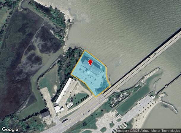
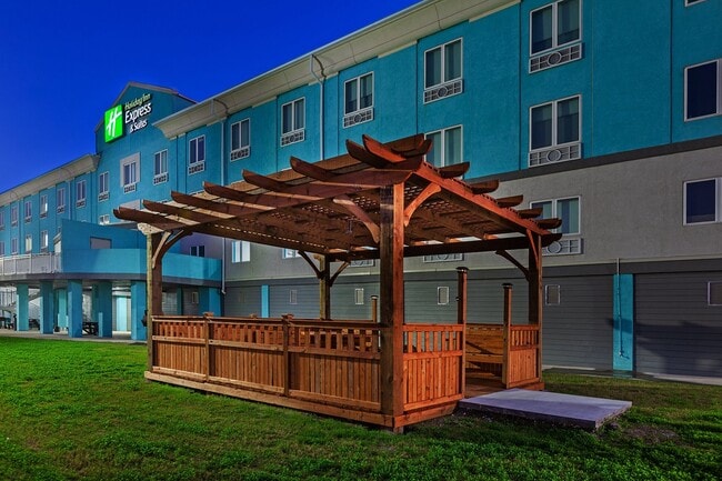
2629 State Highway 35 N, Port Lavaca, TX 77979

NEARBY LISTINGS FOR SALE OR LEASE
-
-
View all Port Lavaca listings for sale on LoopNet.com
Property Detail
2629 State Highway 35 N
77842
The Alejandro Esparza Survey Abstract No
Commercialnec
A0012 ALEJANDRO ESPARZA, TRACT PT 32,34, ACRES 2.68
VE
Calhoun
48057C0065E
Texas
2025
2.68 AC
2025
Texas South Area
000100
Other Market Areas
45,060 SF
Port Lavaca, TX
DEMOGRAPHICS near 2629 State Highway 35 N
1 Mile
3 Mile
5 Mile
2024 Total Population
1,030
10,474
14,148
2029 Population
1,015
10,309
13,884
Pop Growth 2024-2029
(1.46%)
(1.58%)
(1.87%)
Average Age
45
39
39
2024 Total Households
329
3,743
5,120
HH Growth 2024-2029
(2.13%)
(1.63%)
(1.88%)
Median Household Inc
$116,239
$54,189
$61,730
Avg Household Size
2.70
2.70
2.70
2024 Avg HH Vehicles
2.00
2.00
2.00
Median Home Value
$228,488
$132,492
$132,786
Median Year Built
1988
1973
1973
Nearby Places
Map Layers
Map Styles
 Street
 Aerial
- Restaurants
- Banks
- Shops
- Fitness
- Groceries
SALE & LEASE HISTORY
LISTING DATE
SALE/LEASE

Dec 05, 2024
For Sale
Nearby Properties
Address
Land Use
TOTAL SIZE
Lot Size
Zoning
Address
Land Use
TOTAL SIZE
Lot Size
Zoning
13 SF
998.63 AC
Address
Land Use
TOTAL SIZE
Lot Size
Zoning
Address
Land Use
TOTAL SIZE
Lot Size
Zoning
253,184 SF
50 AC
Address
Land Use
TOTAL SIZE
Lot Size
Zoning
93,017 SF
2.56 AC
Address
Land Use
TOTAL SIZE
Lot Size
Zoning
68,115 SF
12.89 AC
Address
Land Use
TOTAL SIZE
Lot Size
Zoning
53,860 SF
2.28 AC
Address
Land Use
TOTAL SIZE
Lot Size
Zoning
155,202 SF
19.21 AC
Address
Land Use
TOTAL SIZE
Lot Size
Zoning
52,320 SF
1.72 AC
Address
Land Use
TOTAL SIZE
Lot Size
Zoning
35,055 SF
1.29 AC
Address
Land Use
TOTAL SIZE
Lot Size
Zoning
29,502 SF
3.30 AC
Address
Land Use
TOTAL SIZE
Lot Size
Zoning
42,848 SF
10.79 AC
Address
Land Use
TOTAL SIZE
Lot Size
Zoning
31,564 SF
8.17 AC
Address
Land Use
TOTAL SIZE
Lot Size
Zoning
47,675 SF
12.04 AC
Address
Land Use
TOTAL SIZE
Lot Size
Zoning
44,571 SF
4.49 AC
Address
Land Use
TOTAL SIZE
Lot Size
Zoning
59,364 SF
5.70 AC
Address
Land Use
TOTAL SIZE
Lot Size
Zoning
55,070 SF
12.79 AC
Address
Land Use
TOTAL SIZE
Lot Size
Zoning
103,451 SF
10 AC
Address
Land Use
TOTAL SIZE
Lot Size
Zoning
46,204 SF
6.82 AC
Address
Land Use
TOTAL SIZE
Lot Size
Zoning
105,600 SF
18.21 AC
Address
Land Use
TOTAL SIZE
Lot Size
Zoning
22,416 SF
8.05 AC
Address
Land Use
TOTAL SIZE
Lot Size
Zoning
114,420 SF
6 AC
Address
Land Use
TOTAL SIZE
Lot Size
Zoning
31.63 AC
Address
Land Use
TOTAL SIZE
Lot Size
Zoning
21,880 SF
12.01 AC
Address
Land Use
TOTAL SIZE
Lot Size
Zoning
36,372 SF
7.21 AC
Address
Land Use
TOTAL SIZE
Lot Size
Zoning
123,240 SF
12.81 AC
Address
Land Use
TOTAL SIZE
Lot Size
Zoning
12,000 SF
1.07 AC
Address
Land Use
TOTAL SIZE
Lot Size
Zoning
254 AC
Address
Land Use
TOTAL SIZE
Lot Size
Zoning
30,007 SF
1.72 AC
Address
Land Use
TOTAL SIZE
Lot Size
Zoning
22,500 SF
5 AC
The World's #1 Commercial Real Estate Marketplace
Connect with us
© 2025 CoStar Group
The information above has been obtained from sources believed reliable. While we do not doubt its accuracy we have not verified it and make no guarantee, warranty or representation about it. It is your responsibility to independently confirm its accuracy and completeness. Any projections, opinions, assumptions, or estimates used are for example only and do not represent the current or future performance of the property. The value of this transaction to you depends on tax and other factors which should be evaluated by your tax, financial, and legal advisors. You and your advisors should conduct a careful, independent investigation of the property to determine to your satisfaction the suitability of the property for your needs.