Property Record
26295 Hilltop Dr, Evergreen, CO 80439
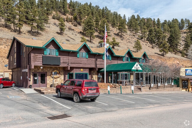

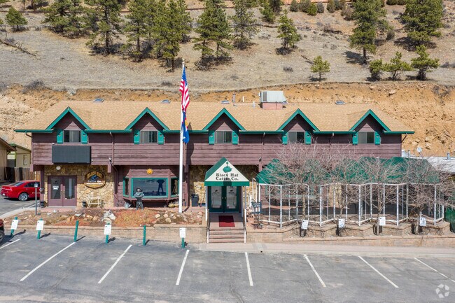

Property Detail
26295 Hilltop Dr
41-354-01-029
SECTION 35 TOWNSHIP 04 RANGE 71 QTR SE SUBDIVISIONCD 425200 SUBDIVISIONNAME KITTREDGE RESUB BLOCK 004 LOT 0018 SIZE: 3250 TRACT VALUE: .075 SECTION 35 TOWNSHIP 04 RANGE 71 QTR SE SUBDIVISIONCD 425200 SUBDIVISIONNAME KITTREDGE RESUB BLOCK 004 LOT 0019
Commercialnec
JEFFERSON
C1
Colorado
B and X Area of moderate flood hazard, usually the area between the limits of the 100-year and 500-year floods.
18-21
2025
0.30 AC
2025
West
009848
Denver
7,514 SF
Denver-Aurora-Centennial, CO
NEARBY LISTINGS FOR SALE OR LEASE
DEMOGRAPHICS near 26295 Hilltop Dr
1 mile
3 mile
5 mile
2025 Total Population
1,224
11,725
23,999
2030 Population
1,183
11,612
23,813
Pop Growth 2025-2030
(3.35%)
(0.96%)
(0.78%)
Average Age
43
46
47
2025 Total Households
478
4,827
9,687
HH Growth 2025-2030
(3.77%)
(1.04%)
(0.89%)
Median Household Inc
$189,141
$159,711
$158,300
Avg Household Size
2.50
2.40
2.40
2025 Avg HH Vehicles
3.00
2.00
2.00
Median Home Value
$825,630
$893,343
$951,505
Median Year Built
1984
1980
1982
Nearby Places
Map Layers
Map Styles
 Street
 Aerial
Layers
 Traffic
 Biking
Places
Listings with unknown addresses are not visible on the map
- Restaurants
- Banks
- Shops
- Fitness
- Groceries
Nearby Properties
Address
Land Use
TOTAL SIZE
Lot Size
Zoning
Address
Land Use
TOTAL SIZE
Lot Size
Zoning
59,012 SF
2.40 AC
PD
Address
Land Use
TOTAL SIZE
Lot Size
Zoning
57,775 SF
4.47 AC
Address
Land Use
TOTAL SIZE
Lot Size
Zoning
35,890 SF
1.84 AC
PD
Address
Land Use
TOTAL SIZE
Lot Size
Zoning
360 AC
CO
Address
Land Use
TOTAL SIZE
Lot Size
Zoning
769.90 AC
CO
Address
Land Use
TOTAL SIZE
Lot Size
Zoning
480 AC
CO
Address
Land Use
TOTAL SIZE
Lot Size
Zoning
9,973 SF
15.50 AC
A2
Address
Land Use
TOTAL SIZE
Lot Size
Zoning
116.70 AC
CO
Address
Land Use
TOTAL SIZE
Lot Size
Zoning
31,437 SF
12.36 AC
PD
Address
Land Use
TOTAL SIZE
Lot Size
Zoning
54,443 SF
4.16 AC
PD
Address
Land Use
TOTAL SIZE
Lot Size
Zoning
17,262 SF
0.91 AC
PD
Address
Land Use
TOTAL SIZE
Lot Size
Zoning
17,554 SF
25.57 AC
A2
Address
Land Use
TOTAL SIZE
Lot Size
Zoning
320 AC
CO
Address
Land Use
TOTAL SIZE
Lot Size
Zoning
35,631 SF
169.48 AC
PD
Address
Land Use
TOTAL SIZE
Lot Size
Zoning
53,371 SF
3.69 AC
C1
Address
Land Use
TOTAL SIZE
Lot Size
Zoning
51,104 SF
5.57 AC
PD
Address
Land Use
TOTAL SIZE
Lot Size
Zoning
34,581 SF
1.98 AC
PD
Address
Land Use
TOTAL SIZE
Lot Size
Zoning
53,106 SF
3.19 AC
C1
Address
Land Use
TOTAL SIZE
Lot Size
Zoning
37,332 SF
5.06 AC
PD
Address
Land Use
TOTAL SIZE
Lot Size
Zoning
23,124 SF
5 AC
A2
Address
Land Use
TOTAL SIZE
Lot Size
Zoning
25,104 SF
1.47 AC
PD
Address
Land Use
TOTAL SIZE
Lot Size
Zoning
5,298 SF
147.29 AC
CO
Address
Land Use
TOTAL SIZE
Lot Size
Zoning
256.19 AC
CO
Address
Land Use
TOTAL SIZE
Lot Size
Zoning
17,510 SF
5.24 AC
MR1
Address
Land Use
TOTAL SIZE
Lot Size
Zoning
14,563 SF
2.21 AC
Address
Land Use
TOTAL SIZE
Lot Size
Zoning
17,230 SF
1.85 AC
C1
Address
Land Use
TOTAL SIZE
Lot Size
Zoning
311.44 AC
PD
Address
Land Use
TOTAL SIZE
Lot Size
Zoning
27,699 SF
2.59 AC
PD
Address
Land Use
TOTAL SIZE
Lot Size
Zoning
11,317 SF
1.45 AC
C1
Address
Land Use
TOTAL SIZE
Lot Size
Zoning
5,753 SF
1.37 AC
PD
The World's #1 Commercial Real Estate Marketplace
Connect with us
© 2026 CoStar Group
The information above has been obtained from sources believed reliable. While we do not doubt its accuracy we have not verified it and make no guarantee, warranty or representation about it. It is your responsibility to independently confirm its accuracy and completeness. Any projections, opinions, assumptions, or estimates used are for example only and do not represent the current or future performance of the property. The value of this transaction to you depends on tax and other factors which should be evaluated by your tax, financial, and legal advisors. You and your advisors should conduct a careful, independent investigation of the property to determine to your satisfaction the suitability of the property for your needs.