Property Record
263 Pearson Dr, Porterville, CA 93257
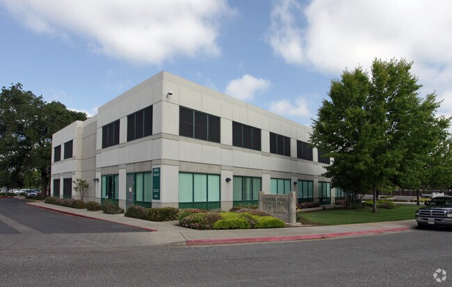

Property Detail
263 Pearson Dr
Visalia, CA
POR LOT 12 WILLIAMS & PREMO VILLA TR RM 7-64 ETC
252-260-083-000
TULARE
Hospitalpublic
California
A Areas with a 1% annual chance of flooding and a 26% chance of flooding over the life of a 30-year mortgage.
12
0
4.96 AC
2025
Porterville
003801
Visalia/Porterville
32,968 SF
NEARBY LISTINGS FOR SALE OR LEASE
DEMOGRAPHICS near 263 Pearson Dr
1 mile
3 mile
5 mile
2025 Total Population
19,089
70,930
77,269
2030 Population
19,354
72,027
78,409
Pop Growth 2025-2030
+ 1.39%
+ 1.55%
+ 1.48%
Average Age
34
35
35
2025 Total Households
5,548
20,418
22,206
HH Growth 2025-2030
+ 1.42%
+ 1.52%
+ 1.44%
Median Household Inc
$51,153
$62,967
$62,797
Avg Household Size
3.30
3.40
3.40
2025 Avg HH Vehicles
2.00
2.00
2.00
Median Home Value
$266,027
$296,991
$298,037
Median Year Built
1969
1981
1981
Nearby Places
Map Layers
Map Styles
 Street
 Aerial
Layers
 Traffic
 Biking
Places
Listings with unknown addresses are not visible on the map
- Restaurants
- Banks
- Shops
- Fitness
- Groceries
Nearby Properties
Address
Land Use
TOTAL SIZE
Lot Size
Zoning
Address
Land Use
TOTAL SIZE
Lot Size
Zoning
Address
Land Use
TOTAL SIZE
Lot Size
Zoning
727,643 SF
43.05 AC
M-1
Address
Land Use
TOTAL SIZE
Lot Size
Zoning
Address
Land Use
TOTAL SIZE
Lot Size
Zoning
Address
Land Use
TOTAL SIZE
Lot Size
Zoning
379,008 SF
36.46 AC
M-1
Address
Land Use
TOTAL SIZE
Lot Size
Zoning
139,487 SF
11.54 AC
CR
Address
Land Use
TOTAL SIZE
Lot Size
Zoning
132,942 SF
10.11 AC
C-2 D
Address
Land Use
TOTAL SIZE
Lot Size
Zoning
103,441 SF
7.83 AC
Address
Land Use
TOTAL SIZE
Lot Size
Zoning
73.61 AC
Address
Land Use
TOTAL SIZE
Lot Size
Zoning
Address
Land Use
TOTAL SIZE
Lot Size
Zoning
Address
Land Use
TOTAL SIZE
Lot Size
Zoning
Address
Land Use
TOTAL SIZE
Lot Size
Zoning
2.52 AC
C-2
Address
Land Use
TOTAL SIZE
Lot Size
Zoning
71,583 SF
6.41 AC
Address
Land Use
TOTAL SIZE
Lot Size
Zoning
82,280 SF
6.41 AC
Address
Land Use
TOTAL SIZE
Lot Size
Zoning
52,620 SF
3.82 AC
Address
Land Use
TOTAL SIZE
Lot Size
Zoning
79,504 SF
4.50 AC
Address
Land Use
TOTAL SIZE
Lot Size
Zoning
Address
Land Use
TOTAL SIZE
Lot Size
Zoning
95,450 SF
11.61 AC
CR
Address
Land Use
TOTAL SIZE
Lot Size
Zoning
125,074 SF
5.96 AC
Address
Land Use
TOTAL SIZE
Lot Size
Zoning
48,032 SF
5 AC
P-D(C)
Address
Land Use
TOTAL SIZE
Lot Size
Zoning
79,970 SF
15.54 AC
Address
Land Use
TOTAL SIZE
Lot Size
Zoning
54,129 SF
3.44 AC
C-3
Address
Land Use
TOTAL SIZE
Lot Size
Zoning
2.07 AC
Address
Land Use
TOTAL SIZE
Lot Size
Zoning
30,036 SF
2.51 AC
PO
Address
Land Use
TOTAL SIZE
Lot Size
Zoning
51,360 SF
3.96 AC
R3-D
Address
Land Use
TOTAL SIZE
Lot Size
Zoning
64,271 SF
1.90 AC
R4D
Address
Land Use
TOTAL SIZE
Lot Size
Zoning
32,167 SF
3.26 AC
The World's #1 Commercial Real Estate Marketplace
Connect with us
© 2026 CoStar Group
The information above has been obtained from sources believed reliable. While we do not doubt its accuracy we have not verified it and make no guarantee, warranty or representation about it. It is your responsibility to independently confirm its accuracy and completeness. Any projections, opinions, assumptions, or estimates used are for example only and do not represent the current or future performance of the property. The value of this transaction to you depends on tax and other factors which should be evaluated by your tax, financial, and legal advisors. You and your advisors should conduct a careful, independent investigation of the property to determine to your satisfaction the suitability of the property for your needs.