Property Record
2634 Gravel Springs Rd, Buford, GA 30519

Save to a Folder
{{folder.Name}}
{{folder.ListingIds.length}} Properties
{{folder.ListingIds.length}} Property
Create a New Folder
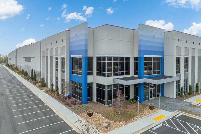
Property Detail
2634 Gravel Springs Rd
7-137-002
GRAVEL SPRINGS RD
Warehouse
GWINNETT
M1
Georgia
B and X Area of moderate flood hazard, usually the area between the limits of the 100-year and 500-year floods.
137
2025
57.50 AC
2025
Duluth/Suwanee/Buford
050634
Atlanta
1,113,809 SF
Atlanta-Sandy Springs-Roswell, GA
NEARBY LISTINGS FOR SALE OR LEASE
-
-
View all Buford listings for lease on LoopNet.com
DEMOGRAPHICS near 2634 Gravel Springs Rd
1 mile
3 mile
5 mile
2025 Total Population
4,392
64,942
155,584
2030 Population
4,643
68,680
163,998
Pop Growth 2025-2030
+ 5.71%
+ 5.76%
+ 5.41%
Average Age
39
38
38
2025 Total Households
1,434
21,168
49,960
HH Growth 2025-2030
+ 5.79%
+ 6.02%
+ 5.59%
Median Household Inc
$83,750
$95,033
$102,359
Avg Household Size
3.00
3.00
3.10
2025 Avg HH Vehicles
2.00
2.00
2.00
Median Home Value
$455,487
$439,948
$436,250
Median Year Built
2007
2004
2002
Nearby Places
Map Layers
Map Styles
 Street
 Aerial
Layers
 Traffic
 Biking
Places
Listings with unknown addresses are not visible on the map
- Restaurants
- Banks
- Shops
- Fitness
- Groceries
SALE & LEASE HISTORY
LISTING DATE
SALE/LEASE

Nov 04, 2022
For Lease
Nearby Properties
Address
Land Use
TOTAL SIZE
Lot Size
Zoning
Address
Land Use
TOTAL SIZE
Lot Size
Zoning
1,435,842 SF
83.47 AC
C2
Address
Land Use
TOTAL SIZE
Lot Size
Zoning
473,883 SF
85.71 AC
RA200
Address
Land Use
TOTAL SIZE
Lot Size
Zoning
563,718 SF
41.75 AC
RM13
Address
Land Use
TOTAL SIZE
Lot Size
Zoning
455,605 SF
33.93 AC
RM13
Address
Land Use
TOTAL SIZE
Lot Size
Zoning
461,593 SF
14.11 AC
MUR
Address
Land Use
TOTAL SIZE
Lot Size
Zoning
403,129 SF
126.91 AC
RA200
Address
Land Use
TOTAL SIZE
Lot Size
Zoning
394,831 SF
16.37 AC
RM24
Address
Land Use
TOTAL SIZE
Lot Size
Zoning
684,003 SF
60.84 AC
M1
Address
Land Use
TOTAL SIZE
Lot Size
Zoning
415,609 SF
16.50 AC
RM24
Address
Land Use
TOTAL SIZE
Lot Size
Zoning
379,178 SF
39.27 AC
RM10
Address
Land Use
TOTAL SIZE
Lot Size
Zoning
619,498 SF
51.81 AC
M1
Address
Land Use
TOTAL SIZE
Lot Size
Zoning
335,641 SF
28.90 AC
RM10
Address
Land Use
TOTAL SIZE
Lot Size
Zoning
282,431 SF
23.20 AC
RM13
Address
Land Use
TOTAL SIZE
Lot Size
Zoning
282,630 SF
11.83 AC
MUO
Address
Land Use
TOTAL SIZE
Lot Size
Zoning
348,358 SF
7.80 AC
H7
Address
Land Use
TOTAL SIZE
Lot Size
Zoning
335,438 SF
10.94 AC
MUR
Address
Land Use
TOTAL SIZE
Lot Size
Zoning
121,100 SF
3.74 AC
RM24
Address
Land Use
TOTAL SIZE
Lot Size
Zoning
192,805 SF
12.40 AC
RM24
Address
Land Use
TOTAL SIZE
Lot Size
Zoning
323,877 SF
29.14 AC
C2
Address
Land Use
TOTAL SIZE
Lot Size
Zoning
102,152 SF
20.95 AC
C2
Address
Land Use
TOTAL SIZE
Lot Size
Zoning
218,583 SF
2.21 AC
MUO
Address
Land Use
TOTAL SIZE
Lot Size
Zoning
223,096 SF
6.06 AC
MUR
Address
Land Use
TOTAL SIZE
Lot Size
Zoning
353,241 SF
33.16 AC
C2
Address
Land Use
TOTAL SIZE
Lot Size
Zoning
280,168 SF
29.08 AC
M1
Address
Land Use
TOTAL SIZE
Lot Size
Zoning
212,293 SF
2.89 AC
MUR
Address
Land Use
TOTAL SIZE
Lot Size
Zoning
72,304 SF
83.10 AC
R100
Address
Land Use
TOTAL SIZE
Lot Size
Zoning
233,266 SF
17.39 AC
RA200
Address
Land Use
TOTAL SIZE
Lot Size
Zoning
352,952 SF
16.97 AC
RM10
Address
Land Use
TOTAL SIZE
Lot Size
Zoning
196,188 SF
19.79 AC
C2
The World's #1 Commercial Real Estate Marketplace
Connect with us
© 2026 CoStar Group
The information above has been obtained from sources believed reliable. While we do not doubt its accuracy we have not verified it and make no guarantee, warranty or representation about it. It is your responsibility to independently confirm its accuracy and completeness. Any projections, opinions, assumptions, or estimates used are for example only and do not represent the current or future performance of the property. The value of this transaction to you depends on tax and other factors which should be evaluated by your tax, financial, and legal advisors. You and your advisors should conduct a careful, independent investigation of the property to determine to your satisfaction the suitability of the property for your needs.