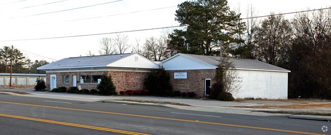
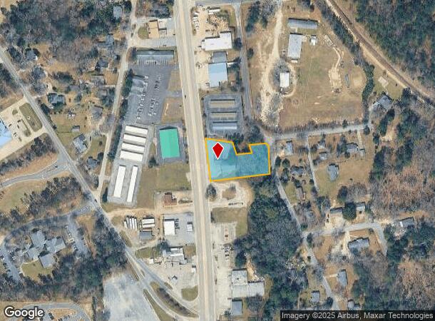
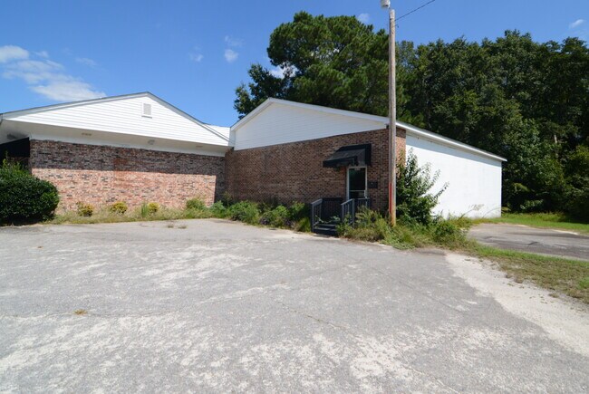
Property Record
2632 Broad St, Camden, SC 29020
NEARBY LISTINGS FOR SALE OR LEASE
Property Detail
2632 Broad St
Columbia, SC
Beard Enterprises Limited Partnership
C257-16-00-059
LOT 11
Medicalbuilding
Kershaw
X
South Carolina
45055C0338F
11
2025
0.90 AC
2025
Kershaw County
970500
Columbia
3,870 SF
DEMOGRAPHICS near 2632 Broad St
1 Mile
3 Mile
5 Mile
2024 Total Population
1,911
14,834
20,955
2029 Population
2,086
16,280
22,945
Pop Growth 2024-2029
+ 9.16%
+ 9.75%
+ 9.50%
Average Age
45
43
42
2024 Total Households
803
6,250
8,768
HH Growth 2024-2029
+ 9.09%
+ 9.60%
+ 9.36%
Median Household Inc
$56,841
$41,207
$42,172
Avg Household Size
2.20
2.30
2.30
2024 Avg HH Vehicles
2.00
2.00
2.00
Median Home Value
$227,037
$179,206
$164,843
Median Year Built
1968
1974
1978
Nearby Places
Map Layers
Map Styles
 Street
 Aerial
- Restaurants
- Banks
- Shops
- Fitness
- Groceries
PUBLIC TRANSPORTATION
COMMUTER RAIL
DRIVE
WALK
Distance
7 min
3.0 mi
AIRPORT
Columbia Metro
DRIVE
WALK
Distance
Columbia Metro
68 min
46.6 mi
SALE & LEASE HISTORY
LISTING DATE
SALE/LEASE

Dec 06, 2022
For Sale
Nearby Properties
Address
Land Use
TOTAL SIZE
Lot Size
Zoning
Address
Land Use
TOTAL SIZE
Lot Size
Zoning
15.09 AC
MUNICIPAL
Address
Land Use
TOTAL SIZE
Lot Size
Zoning
183,825 SF
20.09 AC
MUNICIPAL
Address
Land Use
TOTAL SIZE
Lot Size
Zoning
117,844 SF
12.21 AC
MUNICIPAL
Address
Land Use
TOTAL SIZE
Lot Size
Zoning
3,456 SF
32.16 AC
GD
Address
Land Use
TOTAL SIZE
Lot Size
Zoning
116,508 SF
14.91 AC
MUNICIPAL
Address
Land Use
TOTAL SIZE
Lot Size
Zoning
101,650 SF
8.48 AC
Address
Land Use
TOTAL SIZE
Lot Size
Zoning
85,915 SF
3.57 AC
MUNICIPAL
Address
Land Use
TOTAL SIZE
Lot Size
Zoning
37,794 SF
28.77 AC
GD
Address
Land Use
TOTAL SIZE
Lot Size
Zoning
60,023 SF
5.70 AC
B2
Address
Land Use
TOTAL SIZE
Lot Size
Zoning
75,873 SF
308.84 AC
GD
Address
Land Use
TOTAL SIZE
Lot Size
Zoning
75,636 SF
6.28 AC
MUNICIPAL
Address
Land Use
TOTAL SIZE
Lot Size
Zoning
15,214 SF
1.28 AC
MUNICIPAL
Address
Land Use
TOTAL SIZE
Lot Size
Zoning
71,157 SF
7.19 AC
MUNICIPAL
Address
Land Use
TOTAL SIZE
Lot Size
Zoning
66,678 SF
5.28 AC
R6
Address
Land Use
TOTAL SIZE
Lot Size
Zoning
20.23 AC
MUNICIPAL
Address
Land Use
TOTAL SIZE
Lot Size
Zoning
82,125 SF
8.42 AC
GD
Address
Land Use
TOTAL SIZE
Lot Size
Zoning
22,076 SF
3.53 AC
MUNICIPAL
Address
Land Use
TOTAL SIZE
Lot Size
Zoning
8,804 SF
0.73 AC
Address
Land Use
TOTAL SIZE
Lot Size
Zoning
80,614 SF
7.70 AC
MUNICIPAL
Address
Land Use
TOTAL SIZE
Lot Size
Zoning
91,301 SF
7.32 AC
MUNICIPAL
Address
Land Use
TOTAL SIZE
Lot Size
Zoning
29.23 AC
MUNICIPAL
Address
Land Use
TOTAL SIZE
Lot Size
Zoning
31,296 SF
4.07 AC
MUNICIPAL
Address
Land Use
TOTAL SIZE
Lot Size
Zoning
40,804 SF
3 AC
MUNICIPAL
Address
Land Use
TOTAL SIZE
Lot Size
Zoning
10,726 SF
1.50 AC
MUNICIPAL
Address
Land Use
TOTAL SIZE
Lot Size
Zoning
5,726 SF
1.61 AC
Address
Land Use
TOTAL SIZE
Lot Size
Zoning
10,125 SF
1.09 AC
MUNICIPAL
Address
Land Use
TOTAL SIZE
Lot Size
Zoning
11,502 SF
1.44 AC
MUNICIPAL
Address
Land Use
TOTAL SIZE
Lot Size
Zoning
9.11 AC
R6
Address
Land Use
TOTAL SIZE
Lot Size
Zoning
11,795 SF
97.07 AC
R15
Address
Land Use
TOTAL SIZE
Lot Size
Zoning
4,863 SF
0.99 AC
MUNICIPAL
The World's #1 Commercial Real Estate Marketplace
Connect with us
© 2025 CoStar Group
The information above has been obtained from sources believed reliable. While we do not doubt its accuracy we have not verified it and make no guarantee, warranty or representation about it. It is your responsibility to independently confirm its accuracy and completeness. Any projections, opinions, assumptions, or estimates used are for example only and do not represent the current or future performance of the property. The value of this transaction to you depends on tax and other factors which should be evaluated by your tax, financial, and legal advisors. You and your advisors should conduct a careful, independent investigation of the property to determine to your satisfaction the suitability of the property for your needs.