Property Record
2632 Pemberton Dr, Apopka, FL 32703
NEARBY LISTINGS FOR SALE OR LEASE
Property Detail
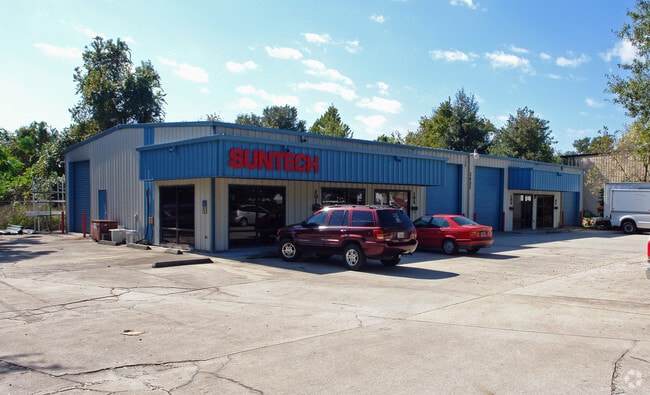
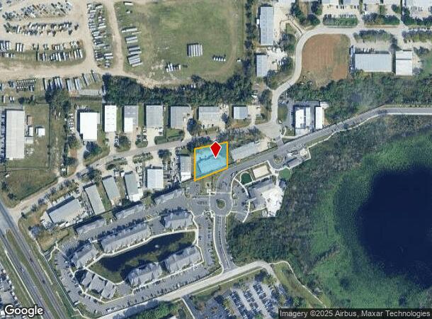
2632 Pemberton Dr
Orlando-Kissimmee-Sanford, FL
Orange Blossom Indus Pk
30-2129-6201-00-130
ORANGE BLOSSOM INDUSTRIAL PARK 15/19 LOT 13
Warehouse
Orange
X
Florida
12095C0140F
13
2024
0.50 AC
2025
NW Orange County
015103
Orlando
5,300 SF
DEMOGRAPHICS near 2632 Pemberton Dr
1 Mile
3 Mile
5 Mile
2024 Total Population
5,581
94,389
247,755
2029 Population
5,817
97,130
255,978
Pop Growth 2024-2029
+ 4.23%
+ 2.90%
+ 3.32%
Average Age
41
39
39
2024 Total Households
1,975
35,411
93,421
HH Growth 2024-2029
+ 4.41%
+ 3.01%
+ 3.48%
Median Household Inc
$78,605
$55,583
$57,034
Avg Household Size
2.70
2.60
2.60
2024 Avg HH Vehicles
2.00
2.00
2.00
Median Home Value
$292,620
$253,712
$270,375
Median Year Built
1992
1986
1984
Nearby Places
Map Layers
Map Styles
 Street
 Aerial
- Restaurants
- Banks
- Shops
- Fitness
- Groceries
PUBLIC TRANSPORTATION
COMMUTER RAIL
DRIVE
WALK
Distance
12 min
7.1 mi
DRIVE
WALK
Distance
16 min
8.1 mi
AIRPORT
Orlando International
DRIVE
WALK
Distance
Orlando International
36 min
22.0 mi
Orlando Sanford International
DRIVE
WALK
Distance
Orlando Sanford International
36 min
22.7 mi
SALE & LEASE HISTORY
LISTING DATE
SALE/LEASE

Apr 09, 2024
For Lease
Apr 02, 2025
For Lease
Nearby Properties
Address
Land Use
TOTAL SIZE
Lot Size
Zoning
Address
Land Use
TOTAL SIZE
Lot Size
Zoning
1,009,074 SF
37.77 AC
PD
Address
Land Use
TOTAL SIZE
Lot Size
Zoning
630,861 SF
31.67 AC
PUDMO
Address
Land Use
TOTAL SIZE
Lot Size
Zoning
745,187 SF
18 AC
PUD
Address
Land Use
TOTAL SIZE
Lot Size
Zoning
34,430 SF
19.99 AC
Address
Land Use
TOTAL SIZE
Lot Size
Zoning
1,674 SF
10.53 AC
R3
Address
Land Use
TOTAL SIZE
Lot Size
Zoning
357 SF
17.05 AC
Address
Land Use
TOTAL SIZE
Lot Size
Zoning
384,447 SF
10.70 AC
P-D
Address
Land Use
TOTAL SIZE
Lot Size
Zoning
468,719 SF
45.46 AC
PD
Address
Land Use
TOTAL SIZE
Lot Size
Zoning
373,462 SF
53.53 AC
IND-4
Address
Land Use
TOTAL SIZE
Lot Size
Zoning
381,557 SF
10.09 AC
PD
Address
Land Use
TOTAL SIZE
Lot Size
Zoning
11,392 SF
8.44 AC
Address
Land Use
TOTAL SIZE
Lot Size
Zoning
631,978 SF
7 AC
PD
Address
Land Use
TOTAL SIZE
Lot Size
Zoning
385,111 SF
12.39 AC
PD
Address
Land Use
TOTAL SIZE
Lot Size
Zoning
269,919 SF
24.44 AC
R-3
Address
Land Use
TOTAL SIZE
Lot Size
Zoning
5,913 SF
14.46 AC
Address
Land Use
TOTAL SIZE
Lot Size
Zoning
257,471 SF
38.42 AC
C-C
Address
Land Use
TOTAL SIZE
Lot Size
Zoning
268,195 SF
50.24 AC
O
Address
Land Use
TOTAL SIZE
Lot Size
Zoning
5,924 SF
17.38 AC
R1A
Address
Land Use
TOTAL SIZE
Lot Size
Zoning
249,311 SF
21.11 AC
R3A
Address
Land Use
TOTAL SIZE
Lot Size
Zoning
228,362 SF
214.60 AC
PUD
Address
Land Use
TOTAL SIZE
Lot Size
Zoning
226,171 SF
9.97 AC
PD
Address
Land Use
TOTAL SIZE
Lot Size
Zoning
497,045 SF
22.03 AC
RMF
Address
Land Use
TOTAL SIZE
Lot Size
Zoning
220,883 SF
53.87 AC
IND-4
Address
Land Use
TOTAL SIZE
Lot Size
Zoning
259,990 SF
14.92 AC
R-3B/W/RP
Address
Land Use
TOTAL SIZE
Lot Size
Zoning
271,076 SF
19.31 AC
PUD
Address
Land Use
TOTAL SIZE
Lot Size
Zoning
313,692 SF
16.37 AC
R-3A/W/RP
Address
Land Use
TOTAL SIZE
Lot Size
Zoning
375,987 SF
15.56 AC
I-L
Address
Land Use
TOTAL SIZE
Lot Size
Zoning
243,354 SF
10.45 AC
R-MF
Address
Land Use
TOTAL SIZE
Lot Size
Zoning
342,011 SF
21.15 AC
I-L
Address
Land Use
TOTAL SIZE
Lot Size
Zoning
1,768 SF
20.77 AC
PUDMO
The World's #1 Commercial Real Estate Marketplace
Connect with us
© 2025 CoStar Group
The information above has been obtained from sources believed reliable. While we do not doubt its accuracy we have not verified it and make no guarantee, warranty or representation about it. It is your responsibility to independently confirm its accuracy and completeness. Any projections, opinions, assumptions, or estimates used are for example only and do not represent the current or future performance of the property. The value of this transaction to you depends on tax and other factors which should be evaluated by your tax, financial, and legal advisors. You and your advisors should conduct a careful, independent investigation of the property to determine to your satisfaction the suitability of the property for your needs.