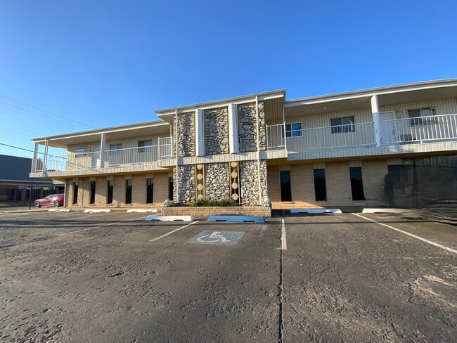
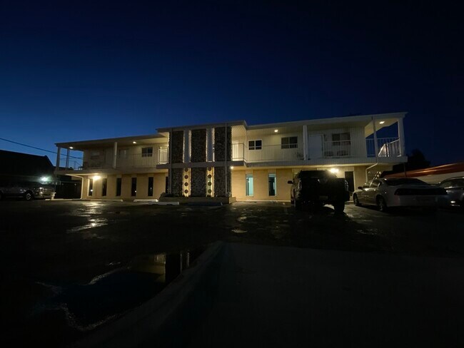
Property Record
2633 Sw 59Th St, Oklahoma City, OK 73119

NEARBY LISTINGS FOR SALE OR LEASE
Property Detail
2633 Sw 59Th St
Oklahoma City, OK
L L Lyon Hillcrest # 1
113421415
L L LYON HILLCREST # 1 002 024
Commercialnec
Oklahoma
X
Oklahoma
40109C0291J
24
2023
0.20 AC
2024
West/Central
107215
Oklahoma City
5,954 SF
DEMOGRAPHICS near 2633 Sw 59Th St
1 Mile
3 Mile
5 Mile
2024 Total Population
18,897
106,081
178,685
2029 Population
19,252
108,887
184,217
Pop Growth 2024-2029
+ 1.88%
+ 2.65%
+ 3.10%
Average Age
34
35
36
2024 Total Households
6,466
37,866
65,576
HH Growth 2024-2029
+ 2.03%
+ 2.71%
+ 3.25%
Median Household Inc
$44,067
$43,386
$46,996
Avg Household Size
2.80
2.70
2.60
2024 Avg HH Vehicles
2.00
2.00
2.00
Median Home Value
$84,819
$97,468
$124,252
Median Year Built
1963
1966
1972
Nearby Places
Map Layers
Map Styles
 Street
 Aerial
- Restaurants
- Banks
- Shops
- Fitness
- Groceries
PUBLIC TRANSPORTATION
COMMUTER RAIL
DRIVE
WALK
Distance
13 min
6.4 mi
AIRPORT
Will Rogers World
DRIVE
WALK
Distance
Will Rogers World
11 min
3.7 mi
SALE & LEASE HISTORY
LISTING DATE
SALE/LEASE

Oct 10, 2019
For Sale
May 15, 2019
For Lease
May 01, 2019
For Sale
Mar 24, 2021
For Sale
Feb 14, 2019
For Lease
Nearby Properties
Address
Land Use
TOTAL SIZE
Lot Size
Zoning
Address
Land Use
TOTAL SIZE
Lot Size
Zoning
192.48 AC
Address
Land Use
TOTAL SIZE
Lot Size
Zoning
64,658 SF
1.86 AC
SPUD
Address
Land Use
TOTAL SIZE
Lot Size
Zoning
Address
Land Use
TOTAL SIZE
Lot Size
Zoning
Address
Land Use
TOTAL SIZE
Lot Size
Zoning
384,708 SF
17.05 AC
R-4
Address
Land Use
TOTAL SIZE
Lot Size
Zoning
27,056 SF
40.77 AC
Address
Land Use
TOTAL SIZE
Lot Size
Zoning
232,037 SF
18.80 AC
C-3
Address
Land Use
TOTAL SIZE
Lot Size
Zoning
239,760 SF
18.52 AC
PUD
Address
Land Use
TOTAL SIZE
Lot Size
Zoning
93,886 SF
8.57 AC
CO
Address
Land Use
TOTAL SIZE
Lot Size
Zoning
192,405 SF
24.38 AC
Address
Land Use
TOTAL SIZE
Lot Size
Zoning
Address
Land Use
TOTAL SIZE
Lot Size
Zoning
39,734 SF
5.16 AC
C-3
Address
Land Use
TOTAL SIZE
Lot Size
Zoning
10,110 SF
10 AC
Address
Land Use
TOTAL SIZE
Lot Size
Zoning
81,929 SF
8.65 AC
PUD
Address
Land Use
TOTAL SIZE
Lot Size
Zoning
203,880 SF
9.93 AC
R-4
Address
Land Use
TOTAL SIZE
Lot Size
Zoning
11,850 SF
1.49 AC
R-2
Address
Land Use
TOTAL SIZE
Lot Size
Zoning
158,150 SF
15.18 AC
I-2
Address
Land Use
TOTAL SIZE
Lot Size
Zoning
233,288 SF
24.24 AC
C-3
Address
Land Use
TOTAL SIZE
Lot Size
Zoning
18,999 SF
2.92 AC
Address
Land Use
TOTAL SIZE
Lot Size
Zoning
204,885 SF
24.62 AC
C-3
Address
Land Use
TOTAL SIZE
Lot Size
Zoning
172,136 SF
8.46 AC
R-4
Address
Land Use
TOTAL SIZE
Lot Size
Zoning
7,496 SF
4.20 AC
Address
Land Use
TOTAL SIZE
Lot Size
Zoning
198,631 SF
13.26 AC
C-3
Address
Land Use
TOTAL SIZE
Lot Size
Zoning
37,192 SF
15.97 AC
C-3
Address
Land Use
TOTAL SIZE
Lot Size
Zoning
66,705 SF
7.64 AC
RM
Address
Land Use
TOTAL SIZE
Lot Size
Zoning
204,532 SF
12.46 AC
R-4
Address
Land Use
TOTAL SIZE
Lot Size
Zoning
33,466 SF
3.24 AC
I-1
Address
Land Use
TOTAL SIZE
Lot Size
Zoning
Address
Land Use
TOTAL SIZE
Lot Size
Zoning
235,670 SF
10.38 AC
R-4
Address
Land Use
TOTAL SIZE
Lot Size
Zoning
271,312 SF
13.06 AC
R-4
The World's #1 Commercial Real Estate Marketplace
Connect with us
© 2026 CoStar Group
The information above has been obtained from sources believed reliable. While we do not doubt its accuracy we have not verified it and make no guarantee, warranty or representation about it. It is your responsibility to independently confirm its accuracy and completeness. Any projections, opinions, assumptions, or estimates used are for example only and do not represent the current or future performance of the property. The value of this transaction to you depends on tax and other factors which should be evaluated by your tax, financial, and legal advisors. You and your advisors should conduct a careful, independent investigation of the property to determine to your satisfaction the suitability of the property for your needs.