Property Record
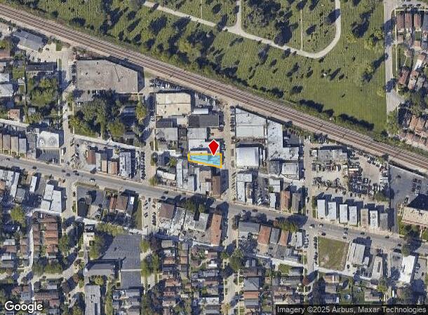
2634 Davisson St, River Grove, IL 60171

NEARBY LISTINGS FOR SALE OR LEASE
Property Detail
2634 Davisson St
Chicago-Naperville-Elgin, IL-IN-WI
Westcotts Turner Park
12-26-406-011-0000
Cook
Industrialgeneral
Illinois
X
5
17031C0387J
0.12 AC
2023
West Cook North
2024
Chicago
811100
DEMOGRAPHICS near 2634 Davisson St
1 Mile
3 Mile
5 Mile
2024 Total Population
26,209
210,654
604,153
2029 Population
25,369
201,662
575,690
Pop Growth 2024-2029
(3.21%)
(4.27%)
(4.71%)
Average Age
42
41
40
2024 Total Households
10,024
74,773
220,817
HH Growth 2024-2029
(3.57%)
(4.52%)
(4.93%)
Median Household Inc
$70,785
$74,033
$70,730
Avg Household Size
2.60
2.70
2.60
2024 Avg HH Vehicles
2.00
2.00
2.00
Median Home Value
$279,725
$291,164
$296,309
Median Year Built
1956
1954
1950
Nearby Places
Map Layers
Map Styles
 Street
 Aerial
- Restaurants
- Banks
- Shops
- Fitness
- Groceries
PUBLIC TRANSPORTATION
TRANSIT/SUBWAY
River Grove Station (Milwaukee District West Line - Northeast Illinois Regional Commuter Railroad (Metra), North Central Service - Northeast Illinois Regional Commuter Railroad (Metra))
DRIVE
WALK
Distance
River Grove Station (Milwaukee District West Line - Northeast Illinois Regional Commuter Railroad (Metra), North Central Service - Northeast Illinois Regional Commuter Railroad (Metra))
2 min
10 min
0.5 mi
Elmwood Park Station (Milwaukee District West Line - Northeast Illinois Regional Commuter Railroad (Metra), North Central Service - Northeast Illinois Regional Commuter Railroad (Metra))
DRIVE
WALK
Distance
Elmwood Park Station (Milwaukee District West Line - Northeast Illinois Regional Commuter Railroad (Metra), North Central Service - Northeast Illinois Regional Commuter Railroad (Metra))
2 min
15 min
0.8 mi
COMMUTER RAIL
River Grove Station (Milwaukee District West Line - Northeast Illinois Regional Commuter Railroad (Metra), North Central Service - Northeast Illinois Regional Commuter Railroad (Metra))
DRIVE
WALK
Distance
River Grove Station (Milwaukee District West Line - Northeast Illinois Regional Commuter Railroad (Metra), North Central Service - Northeast Illinois Regional Commuter Railroad (Metra))
2 min
10 min
0.5 mi
Elmwood Park Station (Milwaukee District West Line - Northeast Illinois Regional Commuter Railroad (Metra), North Central Service - Northeast Illinois Regional Commuter Railroad (Metra))
DRIVE
WALK
Distance
Elmwood Park Station (Milwaukee District West Line - Northeast Illinois Regional Commuter Railroad (Metra), North Central Service - Northeast Illinois Regional Commuter Railroad (Metra))
2 min
15 min
0.8 mi
AIRPORT
Chicago O'Hare International
DRIVE
WALK
Distance
Chicago O'Hare International
14 min
7.5 mi
Chicago Midway International
DRIVE
WALK
Distance
Chicago Midway International
25 min
13.5 mi
Nearby Properties
Address
Land Use
TOTAL SIZE
Lot Size
Zoning
Address
Land Use
TOTAL SIZE
Lot Size
Zoning
86.63 AC
Address
Land Use
TOTAL SIZE
Lot Size
Zoning
422,063 SF
18.88 AC
Address
Land Use
TOTAL SIZE
Lot Size
Zoning
192,365 SF
21.34 AC
PD 127
Address
Land Use
TOTAL SIZE
Lot Size
Zoning
396,650 SF
19.12 AC
Address
Land Use
TOTAL SIZE
Lot Size
Zoning
595,800 SF
9.40 AC
Address
Land Use
TOTAL SIZE
Lot Size
Zoning
9.90 AC
Address
Land Use
TOTAL SIZE
Lot Size
Zoning
Address
Land Use
TOTAL SIZE
Lot Size
Zoning
194,219 SF
17.26 AC
Address
Land Use
TOTAL SIZE
Lot Size
Zoning
548,206 SF
21.13 AC
Address
Land Use
TOTAL SIZE
Lot Size
Zoning
276,458 SF
16.14 AC
Address
Land Use
TOTAL SIZE
Lot Size
Zoning
Address
Land Use
TOTAL SIZE
Lot Size
Zoning
479,130 SF
15.80 AC
Address
Land Use
TOTAL SIZE
Lot Size
Zoning
13.33 AC
PD 127
Address
Land Use
TOTAL SIZE
Lot Size
Zoning
531,227 SF
18.32 AC
Address
Land Use
TOTAL SIZE
Lot Size
Zoning
348,133 SF
2.69 AC
Address
Land Use
TOTAL SIZE
Lot Size
Zoning
141,800 SF
3.77 AC
Address
Land Use
TOTAL SIZE
Lot Size
Zoning
325,045 SF
13.79 AC
Address
Land Use
TOTAL SIZE
Lot Size
Zoning
277,819 SF
10.58 AC
PD 127
Address
Land Use
TOTAL SIZE
Lot Size
Zoning
897,723 SF
23.04 AC
PMD 15
Address
Land Use
TOTAL SIZE
Lot Size
Zoning
141,095 SF
9.15 AC
PD 127
Address
Land Use
TOTAL SIZE
Lot Size
Zoning
Address
Land Use
TOTAL SIZE
Lot Size
Zoning
152,533 SF
12.64 AC
Address
Land Use
TOTAL SIZE
Lot Size
Zoning
790,000 SF
31.71 AC
Address
Land Use
TOTAL SIZE
Lot Size
Zoning
62,844 SF
3.24 AC
Address
Land Use
TOTAL SIZE
Lot Size
Zoning
Address
Land Use
TOTAL SIZE
Lot Size
Zoning
5.38 AC
Address
Land Use
TOTAL SIZE
Lot Size
Zoning
432,777 SF
22.29 AC
Address
Land Use
TOTAL SIZE
Lot Size
Zoning
15.48 AC
Address
Land Use
TOTAL SIZE
Lot Size
Zoning
126,955 SF
13.70 AC
PD 541
Address
Land Use
TOTAL SIZE
Lot Size
Zoning
318,305 SF
12.71 AC
The World's #1 Commercial Real Estate Marketplace
Connect with us
© 2025 CoStar Group
The information above has been obtained from sources believed reliable. While we do not doubt its accuracy we have not verified it and make no guarantee, warranty or representation about it. It is your responsibility to independently confirm its accuracy and completeness. Any projections, opinions, assumptions, or estimates used are for example only and do not represent the current or future performance of the property. The value of this transaction to you depends on tax and other factors which should be evaluated by your tax, financial, and legal advisors. You and your advisors should conduct a careful, independent investigation of the property to determine to your satisfaction the suitability of the property for your needs.