Property Record
26374 Pollard Rd, Daphne, AL 36526


Property Detail
26374 Pollard Rd
43-05-16-0-000-028.014
170'(S) X 625'(S) COM AT THE INT OF E LINE OF POLLARD RD & S LN OF WILSON AVE RUN S ALG POLLARD 511.25' CONT S 132.6' TO THE
Officebuilding
Baldwin
B and X Area of moderate flood hazard, usually the area between the limits of the 100-year and 500-year floods.
Alabama
2025
3.31 AC
2025
Baldwin County
010710
Mobile
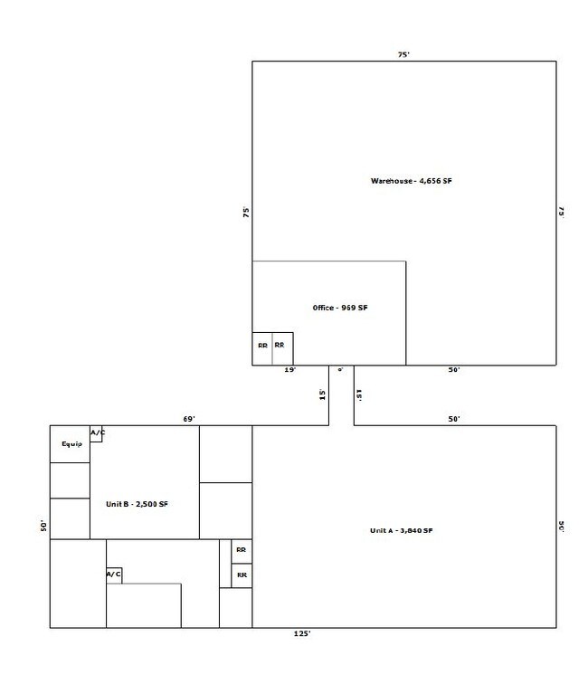
12,038 SF
Daphne-Fairhope-Foley, AL
NEARBY LISTINGS FOR SALE OR LEASE
DEMOGRAPHICS near 26374 Pollard Rd
1 mile
3 mile
5 mile
2025 Total Population
4,253
27,427
46,660
2030 Population
4,636
29,560
50,434
Pop Growth 2025-2030
+ 9.01%
+ 7.78%
+ 8.09%
Average Age
40
40
41
2025 Total Households
1,701
10,780
17,931
HH Growth 2025-2030
+ 8.76%
+ 7.63%
+ 8.00%
Median Household Inc
$76,918
$85,731
$88,922
Avg Household Size
2.40
2.50
2.50
2025 Avg HH Vehicles
2.00
2.00
2.00
Median Home Value
$375,661
$327,802
$331,154
Median Year Built
2000
1994
1996
Nearby Places
Map Layers
Map Styles
 Street
 Aerial
Transit
 Traffic
 Biking
Places
Listings with unknown addresses are not visible on the map
- Restaurants
- Banks
- Shops
- Fitness
- Groceries
PUBLIC TRANSPORTATION
AIRPORT
Mobile International
Drive
Walk
Distance
Mobile International
28 min
17.7 mi
Mobile Regional
Drive
Walk
Distance
Mobile Regional
50 min
31.4 mi
SALE & LEASE HISTORY
LISTING DATE
SALE/LEASE

Sep 15, 2023
For Lease
Jul 17, 2017
For Lease
Apr 10, 2019
For Sale
Nearby Properties
Address
Land Use
TOTAL SIZE
Lot Size
Zoning
Address
Land Use
TOTAL SIZE
Lot Size
Zoning
23,907 SF
21 AC
Address
Land Use
TOTAL SIZE
Lot Size
Zoning
4,160 SF
19 AC
Address
Land Use
TOTAL SIZE
Lot Size
Zoning
17,428 SF
17 AC
Address
Land Use
TOTAL SIZE
Lot Size
Zoning
2,342 SF
13 AC
Address
Land Use
TOTAL SIZE
Lot Size
Zoning
3,310 SF
10 AC
Address
Land Use
TOTAL SIZE
Lot Size
Zoning
20,561 SF
13 AC
Address
Land Use
TOTAL SIZE
Lot Size
Zoning
2,744 SF
15 AC
Address
Land Use
TOTAL SIZE
Lot Size
Zoning
2,935 SF
12 AC
Address
Land Use
TOTAL SIZE
Lot Size
Zoning
7,020 SF
21 AC
Address
Land Use
TOTAL SIZE
Lot Size
Zoning
3,830 SF
9.60 AC
Address
Land Use
TOTAL SIZE
Lot Size
Zoning
203,028 SF
29 AC
Address
Land Use
TOTAL SIZE
Lot Size
Zoning
9,917 SF
9.60 AC
Address
Land Use
TOTAL SIZE
Lot Size
Zoning
92,647 SF
37 AC
Address
Land Use
TOTAL SIZE
Lot Size
Zoning
20,664 SF
7.10 AC
Address
Land Use
TOTAL SIZE
Lot Size
Zoning
57,311 SF
15 AC
Address
Land Use
TOTAL SIZE
Lot Size
Zoning
126,247 SF
13 AC
Address
Land Use
TOTAL SIZE
Lot Size
Zoning
22,158 SF
15 AC
Address
Land Use
TOTAL SIZE
Lot Size
Zoning
Address
Land Use
TOTAL SIZE
Lot Size
Zoning
8.80 AC
Address
Land Use
TOTAL SIZE
Lot Size
Zoning
8,548 SF
9.70 AC
Address
Land Use
TOTAL SIZE
Lot Size
Zoning
29,153 SF
23 AC
Address
Land Use
TOTAL SIZE
Lot Size
Zoning
47,923 SF
12 AC
Address
Land Use
TOTAL SIZE
Lot Size
Zoning
33,372 SF
9.70 AC
Address
Land Use
TOTAL SIZE
Lot Size
Zoning
Address
Land Use
TOTAL SIZE
Lot Size
Zoning
85,018 SF
8.60 AC
Address
Land Use
TOTAL SIZE
Lot Size
Zoning
20,073 SF
5.60 AC
Address
Land Use
TOTAL SIZE
Lot Size
Zoning
42,351 SF
22 AC
Address
Land Use
TOTAL SIZE
Lot Size
Zoning
37,066 SF
3.60 AC
Address
Land Use
TOTAL SIZE
Lot Size
Zoning
3,526 SF
5.70 AC
Address
Land Use
TOTAL SIZE
Lot Size
Zoning
6,025 SF
6 AC
The World's #1 Commercial Real Estate Marketplace
Connect with us
© 2026 CoStar Group
The information above has been obtained from sources believed reliable. While we do not doubt its accuracy we have not verified it and make no guarantee, warranty or representation about it. It is your responsibility to independently confirm its accuracy and completeness. Any projections, opinions, assumptions, or estimates used are for example only and do not represent the current or future performance of the property. The value of this transaction to you depends on tax and other factors which should be evaluated by your tax, financial, and legal advisors. You and your advisors should conduct a careful, independent investigation of the property to determine to your satisfaction the suitability of the property for your needs.