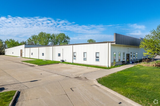
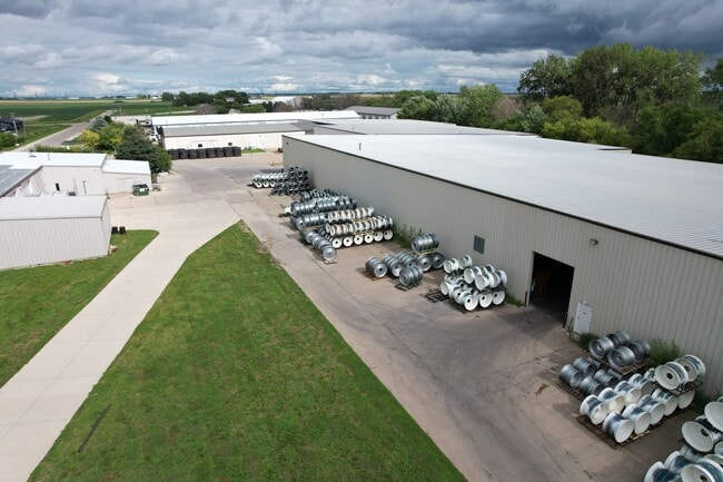
Property Record
26378 289Th Pl, Adel, IA 50003
Save to a Folder
{{folder.Name}}
{{folder.ListingIds.length}} Properties
{{folder.ListingIds.length}} Property
Create a New Folder
This Property Is For Sale
Current Lease Availabilities
Property Detail
26378 289Th Pl
Des Moines-West Des Moines, IA
R & N INDUSTRIAL PARK LOT 4
11-26-300-013
Dallas
Lightindustrial
Iowa
B and X Area of moderate flood hazard, usually the area between the limits of the 100-year and 500-year floods.
4
2024
2.36 AC
2025
Outlying Dallas County
050200
Des Moines
54,500 SF
NEARBY LISTINGS FOR SALE OR LEASE
DEMOGRAPHICS near 26378 289Th Pl
1 mile
3 mile
5 mile
2025 Total Population
152
4,405
23,607
2030 Population
172
4,975
27,115
Pop Growth 2025-2030
+ 13.16%
+ 12.94%
+ 14.86%
Average Age
39
38
38
2025 Total Households
53
1,624
8,797
HH Growth 2025-2030
+ 13.21%
+ 13.24%
+ 15.16%
Median Household Inc
$126,562
$99,135
$107,123
Avg Household Size
2.90
2.70
2.70
2025 Avg HH Vehicles
3.00
2.00
2.00
Median Home Value
$462,499
$350,464
$346,102
Median Year Built
2000
1998
2008
Nearby Places
Map Layers
Map Styles
 Street
 Aerial
Layers
 Traffic
 Biking
Places
Listings with unknown addresses are not visible on the map
- Restaurants
- Banks
- Shops
- Fitness
- Groceries
PUBLIC TRANSPORTATION
AIRPORT
Des Moines International
Drive
Walk
Distance
Des Moines International
36 min
21.3 mi
Freight Ports
Port Milwaukee
Drive
Walk
Distance
Port Milwaukee
437 min
390.3 mi
Nearby Properties
Address
Land Use
TOTAL SIZE
Lot Size
Zoning
Address
Land Use
TOTAL SIZE
Lot Size
Zoning
218.93 AC
Address
Land Use
TOTAL SIZE
Lot Size
Zoning
0.92 AC
Address
Land Use
TOTAL SIZE
Lot Size
Zoning
159,594 SF
38.62 AC
Address
Land Use
TOTAL SIZE
Lot Size
Zoning
28.05 AC
Address
Land Use
TOTAL SIZE
Lot Size
Zoning
Address
Land Use
TOTAL SIZE
Lot Size
Zoning
28,572 SF
1.70 AC
Address
Land Use
TOTAL SIZE
Lot Size
Zoning
8,262 SF
12.61 AC
Address
Land Use
TOTAL SIZE
Lot Size
Zoning
3.79 AC
Address
Land Use
TOTAL SIZE
Lot Size
Zoning
3,029 SF
5.57 AC
Address
Land Use
TOTAL SIZE
Lot Size
Zoning
11,880 SF
5 AC
Address
Land Use
TOTAL SIZE
Lot Size
Zoning
4,775 SF
2.11 AC
Address
Land Use
TOTAL SIZE
Lot Size
Zoning
8,435 SF
0.42 AC
Address
Land Use
TOTAL SIZE
Lot Size
Zoning
19,078 SF
2.57 AC
Address
Land Use
TOTAL SIZE
Lot Size
Zoning
1.46 AC
Address
Land Use
TOTAL SIZE
Lot Size
Zoning
9,348 SF
3.66 AC
Address
Land Use
TOTAL SIZE
Lot Size
Zoning
21,875 SF
3.11 AC
Address
Land Use
TOTAL SIZE
Lot Size
Zoning
5,400 SF
9 AC
Address
Land Use
TOTAL SIZE
Lot Size
Zoning
4,930 SF
0.80 AC
Address
Land Use
TOTAL SIZE
Lot Size
Zoning
6,700 SF
0.68 AC
Address
Land Use
TOTAL SIZE
Lot Size
Zoning
6,306 SF
2.50 AC
Address
Land Use
TOTAL SIZE
Lot Size
Zoning
4,026 SF
1 AC
Address
Land Use
TOTAL SIZE
Lot Size
Zoning
8,534 SF
1.87 AC
Address
Land Use
TOTAL SIZE
Lot Size
Zoning
16,680 SF
0.80 AC
Address
Land Use
TOTAL SIZE
Lot Size
Zoning
4,284 SF
0.39 AC
Address
Land Use
TOTAL SIZE
Lot Size
Zoning
3,358 SF
0.59 AC
Address
Land Use
TOTAL SIZE
Lot Size
Zoning
9,120 SF
1.63 AC
Address
Land Use
TOTAL SIZE
Lot Size
Zoning
2,700 SF
0.33 AC
Address
Land Use
TOTAL SIZE
Lot Size
Zoning
3,379 SF
1.41 AC
The World's #1 Commercial Real Estate Marketplace
Connect with us
© 2026 CoStar Group
The information above has been obtained from sources believed reliable. While we do not doubt its accuracy we have not verified it and make no guarantee, warranty or representation about it. It is your responsibility to independently confirm its accuracy and completeness. Any projections, opinions, assumptions, or estimates used are for example only and do not represent the current or future performance of the property. The value of this transaction to you depends on tax and other factors which should be evaluated by your tax, financial, and legal advisors. You and your advisors should conduct a careful, independent investigation of the property to determine to your satisfaction the suitability of the property for your needs.