Property Record
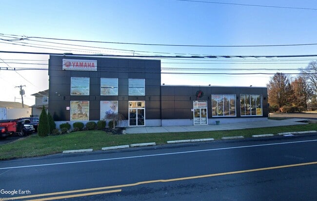
2639 Bristol Pike, Bensalem, PA 19020

Property Detail
2639 Bristol Pike
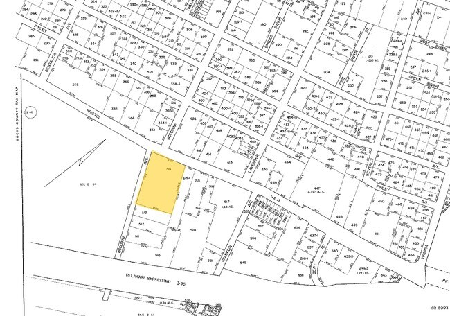
02-062-514
SE COR WOODBINE AV & US13
Storebuilding
BUCKS
HC1
Pennsylvania
B and X Area of moderate flood hazard, usually the area between the limits of the 100-year and 500-year floods.
1.85 AC
2025
Lower Bucks County
2026
Philadelphia
100105
Philadelphia-Camden-Wilmington, PA-NJ-DE-MD
19,814 SF
NEARBY LISTINGS FOR SALE OR LEASE
DEMOGRAPHICS near 2639 Bristol Pike
1 mile
3 mile
5 mile
2025 Total Population
7,621
103,780
276,739
2030 Population
7,668
103,907
277,279
Pop Growth 2025-2030
+ 0.62%
+ 0.12%
+ 0.20%
Average Age
43
42
42
2025 Total Households
2,812
40,286
107,495
HH Growth 2025-2030
+ 0.64%
+ 0.11%
+ 0.05%
Median Household Inc
$95,457
$80,227
$79,271
Avg Household Size
2.60
2.50
2.50
2025 Avg HH Vehicles
2.00
2.00
2.00
Median Home Value
$403,846
$291,233
$298,520
Median Year Built
1967
1967
1967
Nearby Places
Map Layers
Map Styles
 Street
 Aerial
Layers
 Traffic
 Biking
Places
Listings with unknown addresses are not visible on the map
- Restaurants
- Banks
- Shops
- Fitness
- Groceries
PUBLIC TRANSPORTATION
COMMUTER RAIL
Eddington (R7 - Southeastern Pennsylvania Transportation Authority Regional Rail (SEPTA Regional Rail))
Drive
Walk
Distance
Eddington (R7 - Southeastern Pennsylvania Transportation Authority Regional Rail (SEPTA Regional Rail))
2 min
15 min
0.8 mi
Cornwells Heights (R7 - Southeastern Pennsylvania Transportation Authority Regional Rail (SEPTA Regional Rail))
Drive
Walk
Distance
Cornwells Heights (R7 - Southeastern Pennsylvania Transportation Authority Regional Rail (SEPTA Regional Rail))
4 min
1.3 mi
AIRPORT
Trenton Mercer
Drive
Walk
Distance
Trenton Mercer
28 min
18.4 mi
Philadelphia International
Drive
Walk
Distance
Philadelphia International
40 min
26.6 mi
SALE & LEASE HISTORY
LISTING DATE
SALE/LEASE

Apr 16, 2020
For Sale
Nearby Properties
Address
Land Use
TOTAL SIZE
Lot Size
Zoning
Address
Land Use
TOTAL SIZE
Lot Size
Zoning
34,350 SF
336 AC
SPPOA
Address
Land Use
TOTAL SIZE
Lot Size
Zoning
6,290 SF
177.73 AC
RSA4
Address
Land Use
TOTAL SIZE
Lot Size
Zoning
1,615,457 SF
119.41 AC
CA2
Address
Land Use
TOTAL SIZE
Lot Size
Zoning
96 AC
SPPOA
Address
Land Use
TOTAL SIZE
Lot Size
Zoning
2,183 SF
61.10 AC
Address
Land Use
TOTAL SIZE
Lot Size
Zoning
410.98 AC
R2
Address
Land Use
TOTAL SIZE
Lot Size
Zoning
2,550 SF
63.76 AC
SPPOA
Address
Land Use
TOTAL SIZE
Lot Size
Zoning
438,910 SF
24.42 AC
RSA4
Address
Land Use
TOTAL SIZE
Lot Size
Zoning
39.18 AC
Address
Land Use
TOTAL SIZE
Lot Size
Zoning
404,000 SF
1.08 AC
RM2
Address
Land Use
TOTAL SIZE
Lot Size
Zoning
459,320 SF
18 AC
RM2
Address
Land Use
TOTAL SIZE
Lot Size
Zoning
453,038 SF
34.79 AC
I1
Address
Land Use
TOTAL SIZE
Lot Size
Zoning
300,700 SF
30.41 AC
I1
Address
Land Use
TOTAL SIZE
Lot Size
Zoning
207,500 SF
16.18 AC
I1
Address
Land Use
TOTAL SIZE
Lot Size
Zoning
241,392 SF
24.15 AC
I1
Address
Land Use
TOTAL SIZE
Lot Size
Zoning
179,868 SF
11.70 AC
CA2
Address
Land Use
TOTAL SIZE
Lot Size
Zoning
444,322 SF
27.43 AC
SPINS
Address
Land Use
TOTAL SIZE
Lot Size
Zoning
123,411 SF
12.80 AC
RSD3
Address
Land Use
TOTAL SIZE
Lot Size
Zoning
32.72 AC
Address
Land Use
TOTAL SIZE
Lot Size
Zoning
143,342 SF
9.74 AC
CA1
Address
Land Use
TOTAL SIZE
Lot Size
Zoning
Address
Land Use
TOTAL SIZE
Lot Size
Zoning
136,315 SF
11.38 AC
CA1
Address
Land Use
TOTAL SIZE
Lot Size
Zoning
234,965 SF
18.36 AC
CA1
Address
Land Use
TOTAL SIZE
Lot Size
Zoning
112,440 SF
10.58 AC
CA1
Address
Land Use
TOTAL SIZE
Lot Size
Zoning
229,183 SF
19.61 AC
I1
Address
Land Use
TOTAL SIZE
Lot Size
Zoning
88,320 SF
21.03 AC
SPINS
Address
Land Use
TOTAL SIZE
Lot Size
Zoning
74,878 SF
8.45 AC
CA1
Address
Land Use
TOTAL SIZE
Lot Size
Zoning
2,660 SF
23 AC
SPPOA
Address
Land Use
TOTAL SIZE
Lot Size
Zoning
154,048 SF
15.74 AC
I1
Address
Land Use
TOTAL SIZE
Lot Size
Zoning
160,862 SF
5.93 AC
RM2
The World's #1 Commercial Real Estate Marketplace
Connect with us
© 2026 CoStar Group
The information above has been obtained from sources believed reliable. While we do not doubt its accuracy we have not verified it and make no guarantee, warranty or representation about it. It is your responsibility to independently confirm its accuracy and completeness. Any projections, opinions, assumptions, or estimates used are for example only and do not represent the current or future performance of the property. The value of this transaction to you depends on tax and other factors which should be evaluated by your tax, financial, and legal advisors. You and your advisors should conduct a careful, independent investigation of the property to determine to your satisfaction the suitability of the property for your needs.