Property Record
2639 Carpenter Canyon Rd, San Luis Obispo, CA 93401


NEARBY LISTINGS FOR SALE OR LEASE
-
-
View all San Luis Obispo listings for sale on LoopNet.com
Property Detail
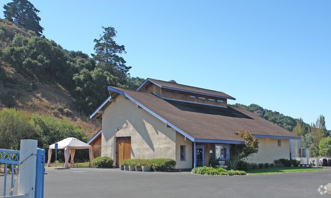
2639 Carpenter Canyon Rd
044-151-015
Ranchos Corral De P
Storebuilding
RHO COR DE P PTN LT 56
X
San Luis Obispo
06079C1355G
California
2021
5.50 AC
2021
South 101 Corridor
012302
San Luis Obispo/Paso Robles
3,522 SF
San Luis Obispo-Paso Robles-Arroyo Grande, CA
DEMOGRAPHICS near 2639 Carpenter Canyon Rd
1 Mile
3 Mile
5 Mile
2024 Total Population
240
2,764
27,306
2029 Population
235
2,695
27,447
Pop Growth 2024-2029
(2.08%)
(2.50%)
+ 0.52%
Average Age
46
46
46
2024 Total Households
94
1,031
11,657
HH Growth 2024-2029
(2.13%)
(2.81%)
+ 0.54%
Median Household Inc
$147,221
$141,442
$104,229
Avg Household Size
2.50
2.50
2.30
2024 Avg HH Vehicles
3.00
3.00
2.00
Median Home Value
$1,107,895
$1,092,916
$934,665
Median Year Built
1985
1982
1985
Nearby Places
Map Layers
Map Styles
 Street
 Aerial
- Restaurants
- Banks
- Shops
- Fitness
- Groceries
PUBLIC TRANSPORTATION
COMMUTER RAIL
San Luis Obispo (Coast Starlight - Amtrak, Pacific Surfliner - Amtrak)
DRIVE
WALK
Distance
San Luis Obispo (Coast Starlight - Amtrak, Pacific Surfliner - Amtrak)
11 min
6.5 mi
Grover Beach Amtrak (Pacific Surfliner - Amtrak)
DRIVE
WALK
Distance
Grover Beach Amtrak (Pacific Surfliner - Amtrak)
11 min
6.8 mi
AIRPORT
San Luis County Regional
DRIVE
WALK
Distance
San Luis County Regional
7 min
3.6 mi
Freight Ports
The Port of Hueneme
DRIVE
WALK
Distance
The Port of Hueneme
162 min
123.8 mi
Nearby Properties
Address
Land Use
TOTAL SIZE
Lot Size
Zoning
Address
Land Use
TOTAL SIZE
Lot Size
Zoning
114,262 SF
5.70 AC
IND
Address
Land Use
TOTAL SIZE
Lot Size
Zoning
66,008 SF
10.75 AC
IND
Address
Land Use
TOTAL SIZE
Lot Size
Zoning
Address
Land Use
TOTAL SIZE
Lot Size
Zoning
36,668 SF
129.30 AC
REC
Address
Land Use
TOTAL SIZE
Lot Size
Zoning
41,976 SF
48.60 AC
AG
Address
Land Use
TOTAL SIZE
Lot Size
Zoning
2,160 SF
63.10 AC
AG
Address
Land Use
TOTAL SIZE
Lot Size
Zoning
36,620 SF
62.61 AC
AG
Address
Land Use
TOTAL SIZE
Lot Size
Zoning
115 AC
AG
Address
Land Use
TOTAL SIZE
Lot Size
Zoning
1,241 SF
218 AC
RL
Address
Land Use
TOTAL SIZE
Lot Size
Zoning
1,254.33 AC
AG
Address
Land Use
TOTAL SIZE
Lot Size
Zoning
Address
Land Use
TOTAL SIZE
Lot Size
Zoning
461 AC
RL
Address
Land Use
TOTAL SIZE
Lot Size
Zoning
26,732 SF
2.26 AC
CS
Address
Land Use
TOTAL SIZE
Lot Size
Zoning
61.69 AC
Address
Land Use
TOTAL SIZE
Lot Size
Zoning
315.92 AC
AG
Address
Land Use
TOTAL SIZE
Lot Size
Zoning
63.22 AC
Address
Land Use
TOTAL SIZE
Lot Size
Zoning
15,756 SF
2.97 AC
CS
Address
Land Use
TOTAL SIZE
Lot Size
Zoning
253.61 AC
RL
Address
Land Use
TOTAL SIZE
Lot Size
Zoning
1,275 SF
355 AC
AG
Address
Land Use
TOTAL SIZE
Lot Size
Zoning
217.50 AC
AG
Address
Land Use
TOTAL SIZE
Lot Size
Zoning
3,217 SF
21.63 AC
AG
Address
Land Use
TOTAL SIZE
Lot Size
Zoning
27,050 SF
2.33 AC
CS
Address
Land Use
TOTAL SIZE
Lot Size
Zoning
970 SF
3.46 AC
IND
Address
Land Use
TOTAL SIZE
Lot Size
Zoning
5,006 SF
40.30 AC
AG
Address
Land Use
TOTAL SIZE
Lot Size
Zoning
24.50 AC
AG
Address
Land Use
TOTAL SIZE
Lot Size
Zoning
Address
Land Use
TOTAL SIZE
Lot Size
Zoning
21.24 AC
RL
Address
Land Use
TOTAL SIZE
Lot Size
Zoning
2,018 SF
1.56 AC
Address
Land Use
TOTAL SIZE
Lot Size
Zoning
Address
Land Use
TOTAL SIZE
Lot Size
Zoning
9,975 SF
1.41 AC
CS
The World's #1 Commercial Real Estate Marketplace
Connect with us
© 2026 CoStar Group
The information above has been obtained from sources believed reliable. While we do not doubt its accuracy we have not verified it and make no guarantee, warranty or representation about it. It is your responsibility to independently confirm its accuracy and completeness. Any projections, opinions, assumptions, or estimates used are for example only and do not represent the current or future performance of the property. The value of this transaction to you depends on tax and other factors which should be evaluated by your tax, financial, and legal advisors. You and your advisors should conduct a careful, independent investigation of the property to determine to your satisfaction the suitability of the property for your needs.