Property Record
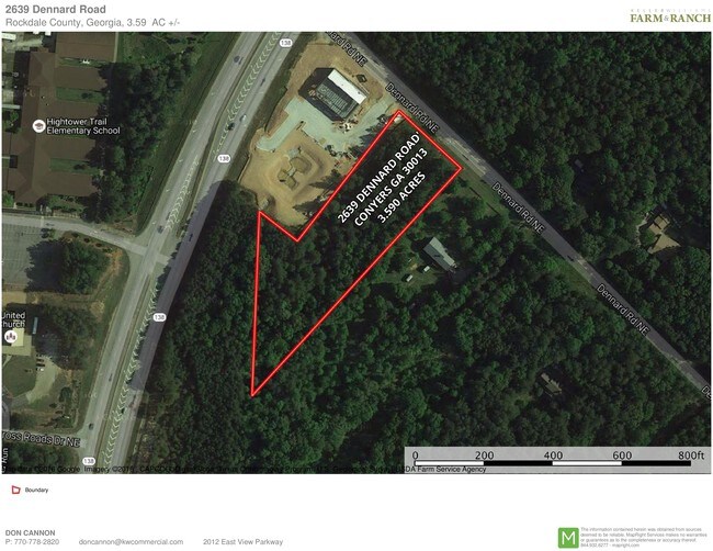
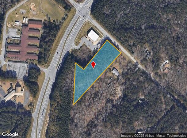
2639 Dennard Rd Ne, Conyers, GA 30013
NEARBY LISTINGS FOR SALE OR LEASE
Property Detail
2639 Dennard Rd Ne
Atlanta-Sandy Springs-Roswell, GA
Commercial
087-0-01-0058
LL362 LD16 S/W SIDE DENNARD RD
Commercialacreage
Rockdale
X
Georgia
13247C0104D
1
2024
2.87 AC
2024
I-20 East/Conyers
060104
Atlanta
DEMOGRAPHICS near 2639 Dennard Rd Ne
1 Mile
3 Mile
5 Mile
2024 Total Population
2,962
16,918
47,073
2029 Population
3,044
17,558
49,309
Pop Growth 2024-2029
+ 2.77%
+ 3.78%
+ 4.75%
Average Age
38
39
38
2024 Total Households
996
6,026
16,664
HH Growth 2024-2029
+ 2.61%
+ 3.73%
+ 4.82%
Median Household Inc
$71,646
$63,503
$63,934
Avg Household Size
2.90
2.70
2.70
2024 Avg HH Vehicles
2.00
2.00
2.00
Median Home Value
$214,572
$205,931
$206,103
Median Year Built
1997
1992
1989
Nearby Places
Map Layers
Map Styles
 Street
 Aerial
- Restaurants
- Banks
- Shops
- Fitness
- Groceries
PUBLIC TRANSPORTATION
AIRPORT
Hartsfield - Jackson Atlanta International
DRIVE
WALK
Distance
Hartsfield - Jackson Atlanta International
45 min
32.9 mi
Freight Ports
Georgia Ports - Savannah
DRIVE
WALK
Distance
Georgia Ports - Savannah
281 min
241.8 mi
SALE & LEASE HISTORY
LISTING DATE
SALE/LEASE

Sep 24, 2016
For Sale
Nearby Properties
Address
Land Use
TOTAL SIZE
Lot Size
Zoning
Address
Land Use
TOTAL SIZE
Lot Size
Zoning
7,806 SF
32.76 AC
RM
Address
Land Use
TOTAL SIZE
Lot Size
Zoning
458,448 SF
12.98 AC
OI
Address
Land Use
TOTAL SIZE
Lot Size
Zoning
454,480 SF
52.17 AC
ID
Address
Land Use
TOTAL SIZE
Lot Size
Zoning
3,256 SF
22.05 AC
RM
Address
Land Use
TOTAL SIZE
Lot Size
Zoning
3,066 SF
22.44 AC
R3/R1
Address
Land Use
TOTAL SIZE
Lot Size
Zoning
3,648 SF
1.02 AC
R3/R1
Address
Land Use
TOTAL SIZE
Lot Size
Zoning
210,380 SF
15.86 AC
ID
Address
Land Use
TOTAL SIZE
Lot Size
Zoning
201,089 SF
13.40 AC
ID
Address
Land Use
TOTAL SIZE
Lot Size
Zoning
5,902 SF
903.52 AC
RES AG
Address
Land Use
TOTAL SIZE
Lot Size
Zoning
17,800 SF
11.36 AC
RM/C
Address
Land Use
TOTAL SIZE
Lot Size
Zoning
180,890 SF
45.15 AC
R1
Address
Land Use
TOTAL SIZE
Lot Size
Zoning
205,716 SF
22.88 AC
ID
Address
Land Use
TOTAL SIZE
Lot Size
Zoning
233,600 SF
69.15 AC
ID
Address
Land Use
TOTAL SIZE
Lot Size
Zoning
140,850 SF
19.09 AC
ID
Address
Land Use
TOTAL SIZE
Lot Size
Zoning
159,014 SF
3.88 AC
RM
Address
Land Use
TOTAL SIZE
Lot Size
Zoning
180,000 SF
12.37 AC
ID
Address
Land Use
TOTAL SIZE
Lot Size
Zoning
28,012 SF
4.04 AC
OI
Address
Land Use
TOTAL SIZE
Lot Size
Zoning
14,575 SF
14.55 AC
OI
Address
Land Use
TOTAL SIZE
Lot Size
Zoning
286.57 AC
RES AG
Address
Land Use
TOTAL SIZE
Lot Size
Zoning
100,800 SF
9 AC
ID
Address
Land Use
TOTAL SIZE
Lot Size
Zoning
89,384 SF
19.92 AC
ID
Address
Land Use
TOTAL SIZE
Lot Size
Zoning
15,419 SF
20.15 AC
PUD
Address
Land Use
TOTAL SIZE
Lot Size
Zoning
225,000 SF
23.50 AC
ID
Address
Land Use
TOTAL SIZE
Lot Size
Zoning
55,928 SF
14.63 AC
BN
Address
Land Use
TOTAL SIZE
Lot Size
Zoning
145,159 SF
1.13 AC
BN
Address
Land Use
TOTAL SIZE
Lot Size
Zoning
122,500 SF
11.30 AC
ID
Address
Land Use
TOTAL SIZE
Lot Size
Zoning
71.95 AC
R1
Address
Land Use
TOTAL SIZE
Lot Size
Zoning
502,000 SF
24.69 AC
M1
Address
Land Use
TOTAL SIZE
Lot Size
Zoning
148,000 SF
10.42 AC
ID
Address
Land Use
TOTAL SIZE
Lot Size
Zoning
174,720 SF
13.54 AC
ID
The World's #1 Commercial Real Estate Marketplace
Connect with us
© 2025 CoStar Group
The information above has been obtained from sources believed reliable. While we do not doubt its accuracy we have not verified it and make no guarantee, warranty or representation about it. It is your responsibility to independently confirm its accuracy and completeness. Any projections, opinions, assumptions, or estimates used are for example only and do not represent the current or future performance of the property. The value of this transaction to you depends on tax and other factors which should be evaluated by your tax, financial, and legal advisors. You and your advisors should conduct a careful, independent investigation of the property to determine to your satisfaction the suitability of the property for your needs.